Property Record
221 Bravo Ter, Port Orchard, WA 98367


NEARBY LISTINGS FOR SALE OR LEASE
Property Detail
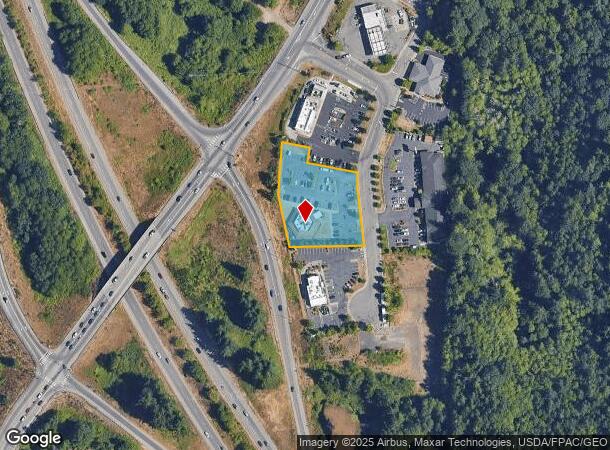
221 Bravo Ter
Bremerton-Silverdale, WA
Southeast Quadrant Of Sedgwick/Sr 16 Int
5458-000-004-00-02
LOT 004, SE QUADRANT OF SEDGWICK/SR16 INTERCHANGE, ACCORDING TO THE PLAT RECORDED IN VOLUME 31 OF PLATS, PAGE(S) 78 - 80, INCLUSIVE, RECORDS OF KITSAP COUNTY, WASHINGTON; SITUATE IN KITSAP COUNTY, WASHINGTON. ALSO TOGETHER WITH A 1/8TH INTEREST IN TR
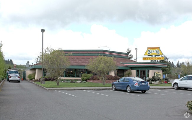
Restaurantbuilding
Kitsap
X
Washington
53035C0369E
004
2025
1.09 AC
2026
South Kitsap County
092801
Bremerton/Silverdale
3,896 SF
DEMOGRAPHICS near 221 Bravo Ter
1 Mile
3 Mile
5 Mile
2024 Total Population
5,083
37,411
80,679
2029 Population
5,277
38,025
81,790
Pop Growth 2024-2029
+ 3.82%
+ 1.64%
+ 1.38%
Average Age
40
40
39
2024 Total Households
1,972
13,939
29,629
HH Growth 2024-2029
+ 3.90%
+ 1.63%
+ 1.58%
Median Household Inc
$64,068
$78,234
$76,711
Avg Household Size
2.50
2.60
2.50
2024 Avg HH Vehicles
2.00
2.00
2.00
Median Home Value
$444,534
$417,901
$409,623
Median Year Built
1993
1988
1984
Nearby Places
Map Layers
Map Styles
 Street
 Aerial
- Restaurants
- Banks
- Shops
- Fitness
- Groceries
PUBLIC TRANSPORTATION
AIRPORT
Seattle-Tacoma International
DRIVE
WALK
Distance
Seattle-Tacoma International
64 min
45.6 mi
Freight Ports
Port of Seattle
DRIVE
WALK
Distance
Port of Seattle
74 min
55.9 mi
SALE & LEASE HISTORY
LISTING DATE
SALE/LEASE

May 22, 2020
For Sale
Apr 04, 2024
For Sale
Nearby Properties
Address
Land Use
TOTAL SIZE
Lot Size
Zoning
Address
Land Use
TOTAL SIZE
Lot Size
Zoning
552 SF
17.39 AC
CITY
Address
Land Use
TOTAL SIZE
Lot Size
Zoning
143,022 SF
11.24 AC
R4
Address
Land Use
TOTAL SIZE
Lot Size
Zoning
127,853 SF
7.41 AC
R4
Address
Land Use
TOTAL SIZE
Lot Size
Zoning
135,371 SF
6.04 AC
R4
Address
Land Use
TOTAL SIZE
Lot Size
Zoning
17,592 SF
11.61 AC
UM
Address
Land Use
TOTAL SIZE
Lot Size
Zoning
25,973 SF
8.20 AC
CC
Address
Land Use
TOTAL SIZE
Lot Size
Zoning
110,994 SF
5.35 AC
R4
Address
Land Use
TOTAL SIZE
Lot Size
Zoning
1,092 SF
5.70 AC
CC
Address
Land Use
TOTAL SIZE
Lot Size
Zoning
125,582 SF
4.02 AC
NC
Address
Land Use
TOTAL SIZE
Lot Size
Zoning
110,778 SF
9.24 AC
CC
Address
Land Use
TOTAL SIZE
Lot Size
Zoning
158,870 SF
14.62 AC
CC
Address
Land Use
TOTAL SIZE
Lot Size
Zoning
185,893 SF
17.89 AC
CC
Address
Land Use
TOTAL SIZE
Lot Size
Zoning
77,580 SF
8.62 AC
UM
Address
Land Use
TOTAL SIZE
Lot Size
Zoning
14,660 SF
6.14 AC
UM
Address
Land Use
TOTAL SIZE
Lot Size
Zoning
14,660 SF
6.07 AC
UM
Address
Land Use
TOTAL SIZE
Lot Size
Zoning
62,642 SF
4.91 AC
UM
Address
Land Use
TOTAL SIZE
Lot Size
Zoning
56,006 SF
4.72 AC
UM
Address
Land Use
TOTAL SIZE
Lot Size
Zoning
73,200 SF
10.25 AC
RI
Address
Land Use
TOTAL SIZE
Lot Size
Zoning
45,379 SF
6.74 AC
UM
Address
Land Use
TOTAL SIZE
Lot Size
Zoning
69,192 SF
3.36 AC
UM
Address
Land Use
TOTAL SIZE
Lot Size
Zoning
2.33 AC
CITY
Address
Land Use
TOTAL SIZE
Lot Size
Zoning
138,087 SF
14.24 AC
CC
Address
Land Use
TOTAL SIZE
Lot Size
Zoning
68,708 SF
7.89 AC
PF
Address
Land Use
TOTAL SIZE
Lot Size
Zoning
520 SF
7.79 AC
C
Address
Land Use
TOTAL SIZE
Lot Size
Zoning
39,800 SF
4.69 AC
CC
Address
Land Use
TOTAL SIZE
Lot Size
Zoning
43,318 SF
2.54 AC
R4
Address
Land Use
TOTAL SIZE
Lot Size
Zoning
85,187 SF
4.30 AC
CC
Address
Land Use
TOTAL SIZE
Lot Size
Zoning
75,000 SF
3.61 AC
LI
Address
Land Use
TOTAL SIZE
Lot Size
Zoning
45,288 SF
1.88 AC
CITY
Address
Land Use
TOTAL SIZE
Lot Size
Zoning
65,956 SF
5.32 AC
CC
The World's #1 Commercial Real Estate Marketplace
Connect with us
© 2025 CoStar Group
The information above has been obtained from sources believed reliable. While we do not doubt its accuracy we have not verified it and make no guarantee, warranty or representation about it. It is your responsibility to independently confirm its accuracy and completeness. Any projections, opinions, assumptions, or estimates used are for example only and do not represent the current or future performance of the property. The value of this transaction to you depends on tax and other factors which should be evaluated by your tax, financial, and legal advisors. You and your advisors should conduct a careful, independent investigation of the property to determine to your satisfaction the suitability of the property for your needs.