Property Record
221 Cpl Roger Snedden Dr, Boone, IA 50036

NEARBY LISTINGS FOR SALE OR LEASE
-
-
View all Boone listings for sale on LoopNet.com
Property Detail
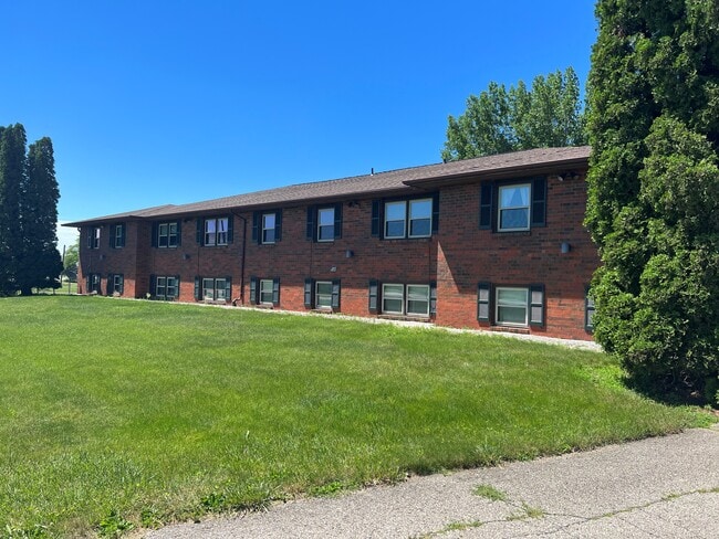
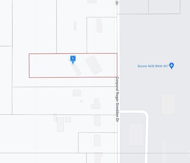
221 Cpl Roger Snedden Dr
088426274182026
NE SE: E 569.6' OF E 1/2 NE SE (EX S 46 9.5' & EX N 688.6' & EX PARCEL E) AND PARCELS C, D & F
Apartment
Boone
X
Iowa
19015C0215D
1.77 AC
2025
Fort Dodge/Ames
2025
Other Market Areas
020300
Ames, IA
11,332 SF
DEMOGRAPHICS near 221 Cpl Roger Snedden Dr
1 Mile
3 Mile
5 Mile
2024 Total Population
2,196
13,422
14,919
2029 Population
2,212
13,460
14,937
Pop Growth 2024-2029
+ 0.73%
+ 0.28%
+ 0.12%
Average Age
41
42
42
2024 Total Households
991
5,803
6,386
HH Growth 2024-2029
+ 0.71%
+ 0.26%
+ 0.11%
Median Household Inc
$62,775
$67,408
$68,790
Avg Household Size
2.20
2.20
2.30
2024 Avg HH Vehicles
2.00
2.00
2.00
Median Home Value
$153,284
$151,547
$157,621
Median Year Built
1957
1956
1958
Nearby Places
Map Layers
Map Styles
 Street
 Aerial
- Restaurants
- Banks
- Shops
- Fitness
- Groceries
SALE & LEASE HISTORY
LISTING DATE
SALE/LEASE

Aug 01, 2022
For Sale
Nearby Properties
Address
Land Use
TOTAL SIZE
Lot Size
Zoning
Address
Land Use
TOTAL SIZE
Lot Size
Zoning
78,878 SF
62.92 AC
Address
Land Use
TOTAL SIZE
Lot Size
Zoning
58,800 SF
56.79 AC
A-2
Address
Land Use
TOTAL SIZE
Lot Size
Zoning
2,792 SF
17.61 AC
Address
Land Use
TOTAL SIZE
Lot Size
Zoning
21,649 SF
35.27 AC
Address
Land Use
TOTAL SIZE
Lot Size
Zoning
640 SF
21.13 AC
I-1
Address
Land Use
TOTAL SIZE
Lot Size
Zoning
84,289 SF
35.01 AC
Address
Land Use
TOTAL SIZE
Lot Size
Zoning
3,356 SF
3.81 AC
Address
Land Use
TOTAL SIZE
Lot Size
Zoning
76,538 SF
32.44 AC
Address
Land Use
TOTAL SIZE
Lot Size
Zoning
120,855 SF
17.19 AC
INC
Address
Land Use
TOTAL SIZE
Lot Size
Zoning
17,028 SF
15 AC
INC
Address
Land Use
TOTAL SIZE
Lot Size
Zoning
29,676 SF
12.55 AC
I-1
Address
Land Use
TOTAL SIZE
Lot Size
Zoning
30,192 SF
5.28 AC
Address
Land Use
TOTAL SIZE
Lot Size
Zoning
77,958 SF
13.04 AC
INC
Address
Land Use
TOTAL SIZE
Lot Size
Zoning
10,742 SF
8.29 AC
Address
Land Use
TOTAL SIZE
Lot Size
Zoning
48,467 SF
7.63 AC
INC
Address
Land Use
TOTAL SIZE
Lot Size
Zoning
68,612 SF
7.79 AC
Address
Land Use
TOTAL SIZE
Lot Size
Zoning
61,442 SF
19.49 AC
INC
Address
Land Use
TOTAL SIZE
Lot Size
Zoning
37,688 SF
8.22 AC
INC
Address
Land Use
TOTAL SIZE
Lot Size
Zoning
16,152 SF
5.87 AC
INC
Address
Land Use
TOTAL SIZE
Lot Size
Zoning
36,958 SF
7.20 AC
Address
Land Use
TOTAL SIZE
Lot Size
Zoning
39,407 SF
6.25 AC
INC
Address
Land Use
TOTAL SIZE
Lot Size
Zoning
15,943 SF
1.78 AC
Address
Land Use
TOTAL SIZE
Lot Size
Zoning
13,476 SF
1.63 AC
Address
Land Use
TOTAL SIZE
Lot Size
Zoning
50,000 SF
7.36 AC
INC
Address
Land Use
TOTAL SIZE
Lot Size
Zoning
22,406 SF
1.82 AC
INC
Address
Land Use
TOTAL SIZE
Lot Size
Zoning
31,658 SF
4.07 AC
INC
Address
Land Use
TOTAL SIZE
Lot Size
Zoning
2,400 SF
9.02 AC
INC
Address
Land Use
TOTAL SIZE
Lot Size
Zoning
7,039 SF
1.34 AC
INC
Address
Land Use
TOTAL SIZE
Lot Size
Zoning
37,680 SF
2.10 AC
INC
Address
Land Use
TOTAL SIZE
Lot Size
Zoning
3.17 AC
The World's #1 Commercial Real Estate Marketplace
Connect with us
© 2026 CoStar Group
The information above has been obtained from sources believed reliable. While we do not doubt its accuracy we have not verified it and make no guarantee, warranty or representation about it. It is your responsibility to independently confirm its accuracy and completeness. Any projections, opinions, assumptions, or estimates used are for example only and do not represent the current or future performance of the property. The value of this transaction to you depends on tax and other factors which should be evaluated by your tax, financial, and legal advisors. You and your advisors should conduct a careful, independent investigation of the property to determine to your satisfaction the suitability of the property for your needs.