Property Record
221 Laurel Lake Dr, North Augusta, SC 29860


NEARBY LISTINGS FOR SALE OR LEASE
-
-
View all North Augusta listings for sale on LoopNet.com
Property Detail
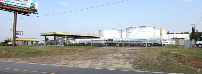
221 Laurel Lake Dr
Augusta-Richmond County, GA-SC
Comm N Augusta Interchange Park
010-19-03-001
LTS 14,15 N OF I-20 E HWY #25
Shipyard
Aiken
X
South Carolina
45003C0310E
14,15
0
9.77 AC
2025
Outlying Aiken County
020500
Augusta/Richmond County
1,864 SF
DEMOGRAPHICS near 221 Laurel Lake Dr
1 Mile
3 Mile
5 Mile
2024 Total Population
2,536
18,619
45,929
2029 Population
2,683
19,997
49,395
Pop Growth 2024-2029
+ 5.80%
+ 7.40%
+ 7.55%
Average Age
44
41
41
2024 Total Households
1,019
7,230
18,074
HH Growth 2024-2029
+ 5.69%
+ 7.34%
+ 7.44%
Median Household Inc
$73,529
$74,307
$65,300
Avg Household Size
2.40
2.50
2.50
2024 Avg HH Vehicles
2.00
2.00
2.00
Median Home Value
$208,996
$189,929
$181,981
Median Year Built
1993
1992
1986
Nearby Places
Map Layers
Map Styles
 Street
 Aerial
- Restaurants
- Banks
- Shops
- Fitness
- Groceries
PUBLIC TRANSPORTATION
AIRPORT
Augusta Regional at Bush Field
DRIVE
WALK
Distance
Augusta Regional at Bush Field
28 min
16.6 mi
Freight Ports
Georgia Ports - Savannah
DRIVE
WALK
Distance
Georgia Ports - Savannah
167 min
126.4 mi
Nearby Properties
Address
Land Use
TOTAL SIZE
Lot Size
Zoning
Address
Land Use
TOTAL SIZE
Lot Size
Zoning
109,272 SF
16.16 AC
Address
Land Use
TOTAL SIZE
Lot Size
Zoning
Address
Land Use
TOTAL SIZE
Lot Size
Zoning
14,750 SF
1.94 AC
Address
Land Use
TOTAL SIZE
Lot Size
Zoning
12,522 SF
13.96 AC
Address
Land Use
TOTAL SIZE
Lot Size
Zoning
8,936 SF
34.56 AC
Address
Land Use
TOTAL SIZE
Lot Size
Zoning
1 SF
8.13 AC
Address
Land Use
TOTAL SIZE
Lot Size
Zoning
10,020 SF
4.20 AC
Address
Land Use
TOTAL SIZE
Lot Size
Zoning
9,488 SF
37.35 AC
Address
Land Use
TOTAL SIZE
Lot Size
Zoning
15,224 SF
2.97 AC
Address
Land Use
TOTAL SIZE
Lot Size
Zoning
3,640 SF
1.61 AC
Address
Land Use
TOTAL SIZE
Lot Size
Zoning
5.35 AC
Address
Land Use
TOTAL SIZE
Lot Size
Zoning
161,778 SF
16.87 AC
Address
Land Use
TOTAL SIZE
Lot Size
Zoning
4.92 AC
Address
Land Use
TOTAL SIZE
Lot Size
Zoning
90,076 SF
10.56 AC
Address
Land Use
TOTAL SIZE
Lot Size
Zoning
Address
Land Use
TOTAL SIZE
Lot Size
Zoning
25,832 SF
2.06 AC
Address
Land Use
TOTAL SIZE
Lot Size
Zoning
6,800 SF
2.48 AC
Address
Land Use
TOTAL SIZE
Lot Size
Zoning
13,036 SF
1.03 AC
Address
Land Use
TOTAL SIZE
Lot Size
Zoning
5,151 SF
1.14 AC
Address
Land Use
TOTAL SIZE
Lot Size
Zoning
Address
Land Use
TOTAL SIZE
Lot Size
Zoning
92,126 SF
15.85 AC
Address
Land Use
TOTAL SIZE
Lot Size
Zoning
9,444 SF
1.93 AC
Address
Land Use
TOTAL SIZE
Lot Size
Zoning
Address
Land Use
TOTAL SIZE
Lot Size
Zoning
108,955 SF
4.61 AC
Address
Land Use
TOTAL SIZE
Lot Size
Zoning
Address
Land Use
TOTAL SIZE
Lot Size
Zoning
Address
Land Use
TOTAL SIZE
Lot Size
Zoning
200 SF
2.87 AC
Address
Land Use
TOTAL SIZE
Lot Size
Zoning
7,536 SF
0.82 AC
Address
Land Use
TOTAL SIZE
Lot Size
Zoning
144.30 AC
The World's #1 Commercial Real Estate Marketplace
Connect with us
© 2026 CoStar Group
The information above has been obtained from sources believed reliable. While we do not doubt its accuracy we have not verified it and make no guarantee, warranty or representation about it. It is your responsibility to independently confirm its accuracy and completeness. Any projections, opinions, assumptions, or estimates used are for example only and do not represent the current or future performance of the property. The value of this transaction to you depends on tax and other factors which should be evaluated by your tax, financial, and legal advisors. You and your advisors should conduct a careful, independent investigation of the property to determine to your satisfaction the suitability of the property for your needs.