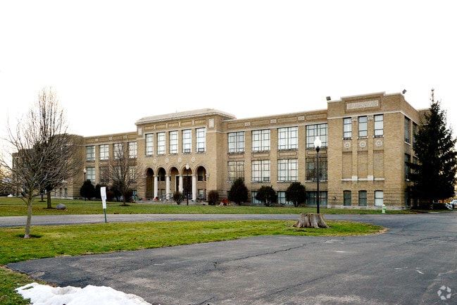
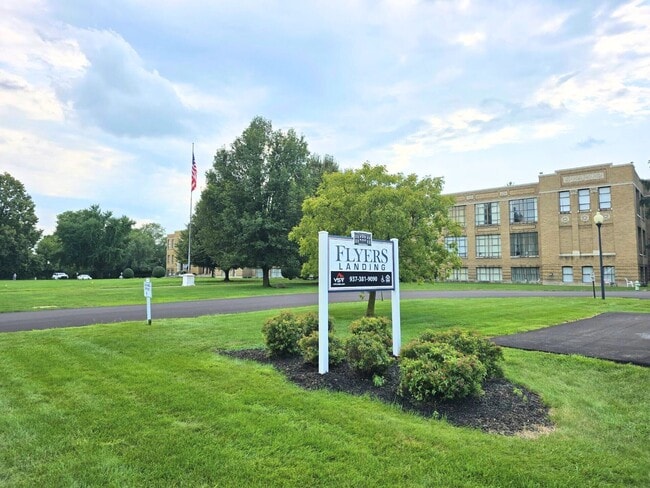
Property Record
221 N Central Ave, Fairborn, OH 45324
NEARBY LISTINGS FOR SALE OR LEASE
-
-
View all Fairborn listings for sale on LoopNet.com
Property Detail
221 N Central Ave
Dayton, OH
Hebble School Plat Section 2
A02-0001-0009-0-0200-00
HEBBLE SCHOOL PLAT SEC 3 LOT 9471 4.1198AC N CENTRAL AVE
Apartment
Greene
AE
Ohio
39057C0010D
9471
2024
4.12 AC
2024
Fairborn/AFB
200400
Cincinnati/Dayton
94,317 SF
DEMOGRAPHICS near 221 N Central Ave
1 Mile
3 Mile
5 Mile
2024 Total Population
7,297
29,944
75,613
2029 Population
7,477
30,730
77,106
Pop Growth 2024-2029
+ 2.47%
+ 2.62%
+ 1.97%
Average Age
39
40
39
2024 Total Households
3,252
13,184
32,007
HH Growth 2024-2029
+ 2.43%
+ 2.62%
+ 2.19%
Median Household Inc
$53,387
$58,882
$68,225
Avg Household Size
2.20
2.20
2.30
2024 Avg HH Vehicles
2.00
2.00
2.00
Median Home Value
$103,536
$139,564
$171,923
Median Year Built
1952
1963
1977
Nearby Places
Map Layers
Map Styles
 Street
 Aerial
- Restaurants
- Banks
- Shops
- Fitness
- Groceries
PUBLIC TRANSPORTATION
AIRPORT
James M Cox Dayton International
DRIVE
WALK
Distance
James M Cox Dayton International
25 min
17.1 mi
Freight Ports
Port of Toledo
DRIVE
WALK
Distance
Port of Toledo
184 min
157.3 mi
Nearby Properties
Address
Land Use
TOTAL SIZE
Lot Size
Zoning
Address
Land Use
TOTAL SIZE
Lot Size
Zoning
101,768 SF
22.02 AC
B1
Address
Land Use
TOTAL SIZE
Lot Size
Zoning
21,740 SF
16.48 AC
Address
Land Use
TOTAL SIZE
Lot Size
Zoning
57,816 SF
9.15 AC
PD1
Address
Land Use
TOTAL SIZE
Lot Size
Zoning
45,204 SF
14.92 AC
PD1
Address
Land Use
TOTAL SIZE
Lot Size
Zoning
46,802 SF
25.30 AC
R3
Address
Land Use
TOTAL SIZE
Lot Size
Zoning
4,494 SF
23.15 AC
R1
Address
Land Use
TOTAL SIZE
Lot Size
Zoning
163,780 SF
36.93 AC
PARK
Address
Land Use
TOTAL SIZE
Lot Size
Zoning
7,040 SF
55.41 AC
R2
Address
Land Use
TOTAL SIZE
Lot Size
Zoning
7,772 SF
8.52 AC
R3
Address
Land Use
TOTAL SIZE
Lot Size
Zoning
14,496 SF
0.64 AC
2
Address
Land Use
TOTAL SIZE
Lot Size
Zoning
46,656 SF
10.35 AC
PD1
Address
Land Use
TOTAL SIZE
Lot Size
Zoning
261,152 SF
15.63 AC
B3
Address
Land Use
TOTAL SIZE
Lot Size
Zoning
24,522 SF
8.46 AC
R3
Address
Land Use
TOTAL SIZE
Lot Size
Zoning
46,005 SF
9.33 AC
PD4
Address
Land Use
TOTAL SIZE
Lot Size
Zoning
38,324 SF
2.77 AC
R4
Address
Land Use
TOTAL SIZE
Lot Size
Zoning
3,456 SF
5.66 AC
PD1
Address
Land Use
TOTAL SIZE
Lot Size
Zoning
31,338 SF
0.25 AC
B2
Address
Land Use
TOTAL SIZE
Lot Size
Zoning
11,176 SF
9.03 AC
Address
Land Use
TOTAL SIZE
Lot Size
Zoning
101,824 SF
6.13 AC
R4
Address
Land Use
TOTAL SIZE
Lot Size
Zoning
11,631 SF
2.44 AC
B3
Address
Land Use
TOTAL SIZE
Lot Size
Zoning
53.70 AC
PD2
Address
Land Use
TOTAL SIZE
Lot Size
Zoning
121,316 SF
20.43 AC
AG
Address
Land Use
TOTAL SIZE
Lot Size
Zoning
48,228 SF
1.60 AC
R4
Address
Land Use
TOTAL SIZE
Lot Size
Zoning
54,900 SF
4 AC
R-1
Address
Land Use
TOTAL SIZE
Lot Size
Zoning
31,907 SF
10.96 AC
Address
Land Use
TOTAL SIZE
Lot Size
Zoning
79,032 SF
15.40 AC
IR
Address
Land Use
TOTAL SIZE
Lot Size
Zoning
27,500 SF
18.01 AC
I2
Address
Land Use
TOTAL SIZE
Lot Size
Zoning
17,822 SF
1.88 AC
R1
Address
Land Use
TOTAL SIZE
Lot Size
Zoning
74,144 SF
6.58 AC
R4
The World's #1 Commercial Real Estate Marketplace
Connect with us
© 2026 CoStar Group
The information above has been obtained from sources believed reliable. While we do not doubt its accuracy we have not verified it and make no guarantee, warranty or representation about it. It is your responsibility to independently confirm its accuracy and completeness. Any projections, opinions, assumptions, or estimates used are for example only and do not represent the current or future performance of the property. The value of this transaction to you depends on tax and other factors which should be evaluated by your tax, financial, and legal advisors. You and your advisors should conduct a careful, independent investigation of the property to determine to your satisfaction the suitability of the property for your needs.