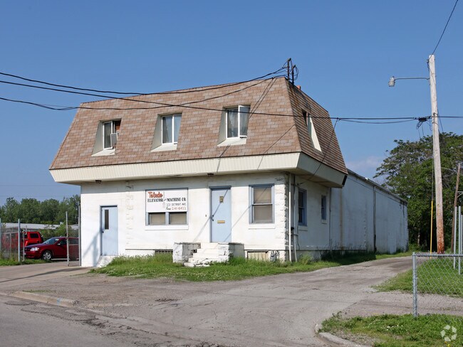
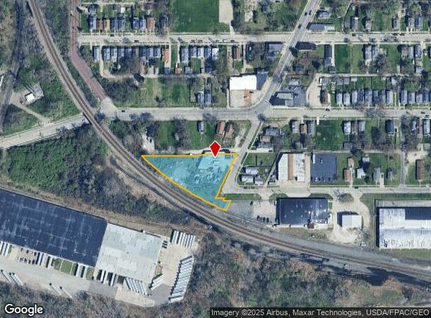
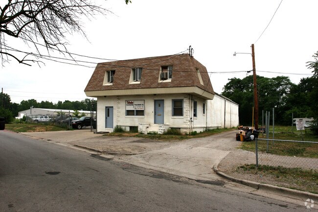
Property Record
221 N Detroit Ave, Toledo, OH 43607
NEARBY LISTINGS FOR SALE OR LEASE
Property Detail
221 N Detroit Ave
Toledo, OH
Campbells Second Addn
03-00804
CAMPBELLS SECOND ADDN LOT 63 TO 74 & PT ALLEY ADJ VAC & PT VAC CAMPB
Lightindustrial
Lucas
X
Ohio
39095C0089F
63-74
2024
1 AC
2024
South/Southwest
003500
Toledo
6,026 SF
DEMOGRAPHICS near 221 N Detroit Ave
1 Mile
3 Mile
5 Mile
2024 Total Population
11,658
94,995
237,741
2029 Population
11,699
95,040
236,367
Pop Growth 2024-2029
+ 0.35%
+ 0.05%
(0.58%)
Average Age
38
37
38
2024 Total Households
4,946
40,839
101,714
HH Growth 2024-2029
+ 0.32%
+ 0.07%
(0.66%)
Median Household Inc
$37,030
$36,957
$42,996
Avg Household Size
2.30
2.10
2.20
2024 Avg HH Vehicles
2.00
1.00
2.00
Median Home Value
$58,869
$83,749
$98,907
Median Year Built
1947
1949
1953
Nearby Places
Map Layers
Map Styles
 Street
 Aerial
- Restaurants
- Banks
- Shops
- Fitness
- Groceries
PUBLIC TRANSPORTATION
COMMUTER RAIL
DRIVE
WALK
Distance
7 min
3.7 mi
AIRPORT
Eugene F Kranz Toledo Express
DRIVE
WALK
Distance
Eugene F Kranz Toledo Express
32 min
17.3 mi
Nearby Properties
Address
Land Use
TOTAL SIZE
Lot Size
Zoning
Address
Land Use
TOTAL SIZE
Lot Size
Zoning
3,101,694 SF
35.64 AC
10-IC
Address
Land Use
TOTAL SIZE
Lot Size
Zoning
3,076,310 SF
127.88 AC
10-MX
Address
Land Use
TOTAL SIZE
Lot Size
Zoning
1,237,446 SF
193.94 AC
10-RS12
Address
Land Use
TOTAL SIZE
Lot Size
Zoning
1,243,593 SF
42.25 AC
10-MX
Address
Land Use
TOTAL SIZE
Lot Size
Zoning
1,046,727 SF
0.41 AC
10-IC
Address
Land Use
TOTAL SIZE
Lot Size
Zoning
513,157 SF
39.38 AC
10-MX
Address
Land Use
TOTAL SIZE
Lot Size
Zoning
277,862 SF
3 AC
10-CD
Address
Land Use
TOTAL SIZE
Lot Size
Zoning
436,094 SF
30.06 AC
10-RS6
Address
Land Use
TOTAL SIZE
Lot Size
Zoning
323,421 SF
134.98 AC
10-MX
Address
Land Use
TOTAL SIZE
Lot Size
Zoning
249,216 SF
6.71 AC
10-IC
Address
Land Use
TOTAL SIZE
Lot Size
Zoning
625,485 SF
2 AC
10-MX
Address
Land Use
TOTAL SIZE
Lot Size
Zoning
111,471 SF
6.17 AC
10-CD
Address
Land Use
TOTAL SIZE
Lot Size
Zoning
171,946 SF
0.17 AC
10-IC
Address
Land Use
TOTAL SIZE
Lot Size
Zoning
328,568 SF
16.37 AC
10-CO
Address
Land Use
TOTAL SIZE
Lot Size
Zoning
202,563 SF
6.19 AC
10-IG
Address
Land Use
TOTAL SIZE
Lot Size
Zoning
245,237 SF
31.72 AC
10-MX
Address
Land Use
TOTAL SIZE
Lot Size
Zoning
1.74 AC
10-CD
Address
Land Use
TOTAL SIZE
Lot Size
Zoning
296,348 SF
1 AC
10-CO
Address
Land Use
TOTAL SIZE
Lot Size
Zoning
243,165 SF
3.63 AC
10-CD
Address
Land Use
TOTAL SIZE
Lot Size
Zoning
11.16 AC
10-RM24
Address
Land Use
TOTAL SIZE
Lot Size
Zoning
393,343 SF
62.48 AC
10-IC
Address
Land Use
TOTAL SIZE
Lot Size
Zoning
375,323 SF
10-IC
Address
Land Use
TOTAL SIZE
Lot Size
Zoning
72,306 SF
0.09 AC
10-IC
Address
Land Use
TOTAL SIZE
Lot Size
Zoning
940,263 SF
0.52 AC
10-MX
Address
Land Use
TOTAL SIZE
Lot Size
Zoning
148,842 SF
9.84 AC
10-IL
Address
Land Use
TOTAL SIZE
Lot Size
Zoning
174,496 SF
7.30 AC
Address
Land Use
TOTAL SIZE
Lot Size
Zoning
246,438 SF
8.22 AC
10-RM36
Address
Land Use
TOTAL SIZE
Lot Size
Zoning
182,983 SF
2 AC
10-CD
Address
Land Use
TOTAL SIZE
Lot Size
Zoning
123,064 SF
10 AC
10-RS6
Address
Land Use
TOTAL SIZE
Lot Size
Zoning
317,139 SF
25.80 AC
10-IC
The World's #1 Commercial Real Estate Marketplace
Connect with us
© 2025 CoStar Group
The information above has been obtained from sources believed reliable. While we do not doubt its accuracy we have not verified it and make no guarantee, warranty or representation about it. It is your responsibility to independently confirm its accuracy and completeness. Any projections, opinions, assumptions, or estimates used are for example only and do not represent the current or future performance of the property. The value of this transaction to you depends on tax and other factors which should be evaluated by your tax, financial, and legal advisors. You and your advisors should conduct a careful, independent investigation of the property to determine to your satisfaction the suitability of the property for your needs.