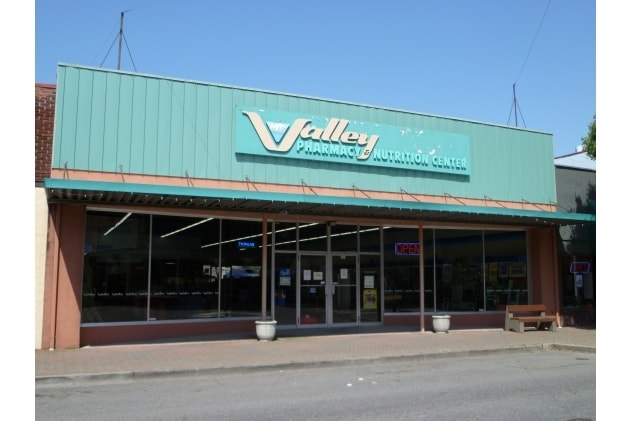
Property Record
221 S 1St St, Mount Vernon, WA 98273
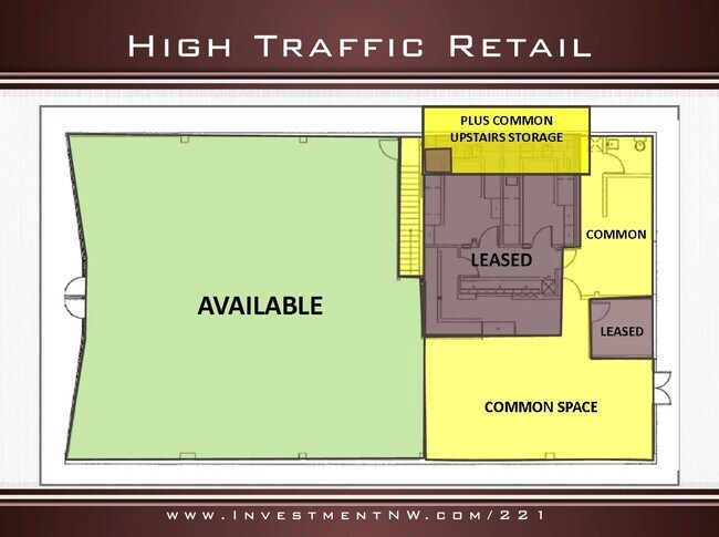
Current Lease Availabilities
NEARBY LISTINGS FOR SALE OR LEASE
Property Detail
221 S 1St St
Other Market Areas
Gates 1St And 2Nd Additions
Mount Vernon-Anacortes, WA
(0.0195)(DK 3) THE SOUTHEASTERLY 25 FEET OF LOT 5, EXCEPT THE SOUTHEASTERLY 8 FEET THEREOF, BLOCK 3, MT VERNON, GATES 1ST AND 2ND ADDITIONS, AS PER PLAT RECORDED IN VOLUME 2 OF PLATS, PAGE 98, RECORDS OF SKAGIT COUNTY, WASHINGTON.
P52006
Skagit
Storebuilding
Washington
2025
5
2025
0.11 AC
9525003004
Bellingham/Northwest
4,600 SF
DEMOGRAPHICS near 221 S 1St St
1 Mile
3 Mile
5 Mile
2024 Total Population
9,222
41,234
58,485
2029 Population
9,621
43,046
61,030
Pop Growth 2024-2029
+ 4.33%
+ 4.39%
+ 4.35%
Average Age
39
40
40
2024 Total Households
3,620
15,203
21,553
HH Growth 2024-2029
+ 4.48%
+ 4.52%
+ 4.48%
Median Household Inc
$52,338
$63,109
$64,857
Avg Household Size
2.50
2.60
2.60
2024 Avg HH Vehicles
2.00
2.00
2.00
Median Home Value
$379,751
$408,243
$422,115
Median Year Built
1963
1986
1986
Nearby Places
- Restaurants
- Banks
- Shops
- Fitness
- Groceries
PUBLIC TRANSPORTATION
COMMUTER RAIL
Mount Vernon Amtrak Station (Amtrak Cascades - Amtrak)
DRIVE
WALK
Distance
Mount Vernon Amtrak Station (Amtrak Cascades - Amtrak)
1 min
4 min
0.3 mi
AIRPORT
Bellingham International
DRIVE
WALK
Distance
Bellingham International
42 min
33.0 mi
Freight Ports
Port of Anacortes
DRIVE
WALK
Distance
Port of Anacortes
25 min
16.8 mi
Nearby Properties
Address
Land Use
TOTAL SIZE
Lot Size
Zoning
Address
Land Use
TOTAL SIZE
Lot Size
Zoning
404,511 SF
9.01 AC
Address
Land Use
TOTAL SIZE
Lot Size
Zoning
16,345 SF
32.99 AC
Address
Land Use
TOTAL SIZE
Lot Size
Zoning
Address
Land Use
TOTAL SIZE
Lot Size
Zoning
1,500 SF
9.93 AC
Address
Land Use
TOTAL SIZE
Lot Size
Zoning
Address
Land Use
TOTAL SIZE
Lot Size
Zoning
77,414 SF
15.20 AC
Address
Land Use
TOTAL SIZE
Lot Size
Zoning
219,575 SF
27.34 AC
Address
Land Use
TOTAL SIZE
Lot Size
Zoning
212,480 SF
35.36 AC
Address
Land Use
TOTAL SIZE
Lot Size
Zoning
105,000 SF
1 AC
Address
Land Use
TOTAL SIZE
Lot Size
Zoning
171,214 SF
4.40 AC
Address
Land Use
TOTAL SIZE
Lot Size
Zoning
200,145 SF
9.35 AC
Address
Land Use
TOTAL SIZE
Lot Size
Zoning
148,868 SF
17.53 AC
Address
Land Use
TOTAL SIZE
Lot Size
Zoning
74,608 SF
87 SF
Address
Land Use
TOTAL SIZE
Lot Size
Zoning
Address
Land Use
TOTAL SIZE
Lot Size
Zoning
0.01 AC
Address
Land Use
TOTAL SIZE
Lot Size
Zoning
138,226 SF
30.55 AC
Address
Land Use
TOTAL SIZE
Lot Size
Zoning
2,468 SF
0.68 AC
Address
Land Use
TOTAL SIZE
Lot Size
Zoning
0.01 AC
Address
Land Use
TOTAL SIZE
Lot Size
Zoning
64,668 SF
0.29 AC
Address
Land Use
TOTAL SIZE
Lot Size
Zoning
114,589 SF
10.63 AC
Address
Land Use
TOTAL SIZE
Lot Size
Zoning
52,239 SF
5.50 AC
Address
Land Use
TOTAL SIZE
Lot Size
Zoning
0.01 AC
Address
Land Use
TOTAL SIZE
Lot Size
Zoning
138,353 SF
10 AC
Address
Land Use
TOTAL SIZE
Lot Size
Zoning
68,326 SF
5.29 AC
Address
Land Use
TOTAL SIZE
Lot Size
Zoning
Address
Land Use
TOTAL SIZE
Lot Size
Zoning
74,419 SF
2.16 AC
Address
Land Use
TOTAL SIZE
Lot Size
Zoning
44,812 SF
6 AC
Address
Land Use
TOTAL SIZE
Lot Size
Zoning
55,326 SF
9.12 AC
Address
Land Use
TOTAL SIZE
Lot Size
Zoning
143,806 SF
5.50 AC
Address
Land Use
TOTAL SIZE
Lot Size
Zoning
93,720 SF
4.82 AC
The World's #1 Commercial Real Estate Marketplace
Connect with us
© 2025 CoStar Group
The information above has been obtained from sources believed reliable. While we do not doubt its accuracy we have not verified it and make no guarantee, warranty or representation about it. It is your responsibility to independently confirm its accuracy and completeness. Any projections, opinions, assumptions, or estimates used are for example only and do not represent the current or future performance of the property. The value of this transaction to you depends on tax and other factors which should be evaluated by your tax, financial, and legal advisors. You and your advisors should conduct a careful, independent investigation of the property to determine to your satisfaction the suitability of the property for your needs.