Property Record
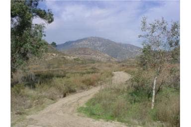
2210 Bailey Canyon Rd, San Bernardino, CA 92407
NEARBY LISTINGS FOR SALE OR LEASE
Property Detail
2210 Bailey Canyon Rd
Riverside-San Bernardino-Ontario, CA
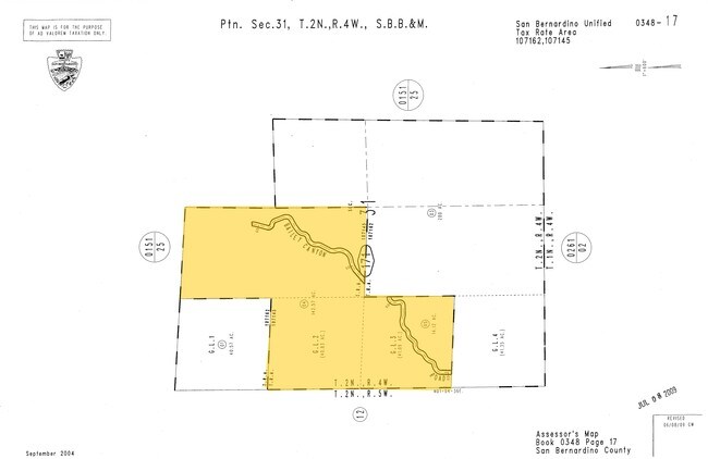
E 1/2 NW 1/4 SEC 31 TP 2N R 4W AND GOV LOT 2 AND PTN GOV LOT 3 SD SEC LYING NLY OF NLY LI BAILEY CANYON RD AS DESC IN EASEMENT DEED RECORDED IN BOOK 7727 PAGE 683 O R EX PTN IN SD RD LYING WITHIN SD E 1/2 NW 1/4 142.57 AC M/L
0348-171-04
San Bernardino
Vacantlandnec
California
X
2
06071C7930J
142.57 AC
2024
San Bernardino
2025
Inland Empire (California)
004601
DEMOGRAPHICS near 2210 Bailey Canyon Rd
1 Mile
3 Mile
5 Mile
2024 Total Population
222
14,588
71,355
2029 Population
223
14,693
71,872
Pop Growth 2024-2029
+ 0.45%
+ 0.72%
+ 0.72%
Average Age
36
36
35
2024 Total Households
67
4,586
21,292
HH Growth 2024-2029
0.00%
+ 0.37%
+ 0.43%
Median Household Inc
$107,291
$95,938
$82,179
Avg Household Size
3.40
3.10
3.20
2024 Avg HH Vehicles
3.00
3.00
2.00
Median Home Value
$467,999
$469,849
$426,702
Median Year Built
1988
1986
1981
Nearby Places
Map Layers
Map Styles
 Street
 Aerial
- Restaurants
- Banks
- Shops
- Fitness
- Groceries
PUBLIC TRANSPORTATION
COMMUTER RAIL
San Bernardino (Inland Empire-Orange County Line - Southern California Regional Rail Authority (Metrolink), San Bernardino Line - Southern California Regional Rail Authority (Metrolink))
DRIVE
WALK
Distance
San Bernardino (Inland Empire-Orange County Line - Southern California Regional Rail Authority (Metrolink), San Bernardino Line - Southern California Regional Rail Authority (Metrolink))
17 min
9.6 mi
AIRPORT
Ontario International
DRIVE
WALK
Distance
Ontario International
37 min
26.1 mi
Freight Ports
Port of Long Beach
DRIVE
WALK
Distance
Port of Long Beach
98 min
75.5 mi
Nearby Properties
Address
Land Use
TOTAL SIZE
Lot Size
Zoning
Address
Land Use
TOTAL SIZE
Lot Size
Zoning
805,980 SF
39.57 AC
Address
Land Use
TOTAL SIZE
Lot Size
Zoning
830,613 SF
35.21 AC
Address
Land Use
TOTAL SIZE
Lot Size
Zoning
335,460 SF
16.45 AC
Address
Land Use
TOTAL SIZE
Lot Size
Zoning
250,111 SF
12.04 AC
Address
Land Use
TOTAL SIZE
Lot Size
Zoning
730,988 SF
32.09 AC
GHSP
Address
Land Use
TOTAL SIZE
Lot Size
Zoning
843,440 SF
35.85 AC
Address
Land Use
TOTAL SIZE
Lot Size
Zoning
624,376 SF
37.65 AC
Address
Land Use
TOTAL SIZE
Lot Size
Zoning
671,229 SF
19.50 AC
Address
Land Use
TOTAL SIZE
Lot Size
Zoning
321,496 SF
21.24 AC
Address
Land Use
TOTAL SIZE
Lot Size
Zoning
52,258 SF
8.90 AC
Address
Land Use
TOTAL SIZE
Lot Size
Zoning
211,703 SF
12.34 AC
Address
Land Use
TOTAL SIZE
Lot Size
Zoning
76,234 SF
24.42 AC
Address
Land Use
TOTAL SIZE
Lot Size
Zoning
392,650 SF
20.14 AC
Address
Land Use
TOTAL SIZE
Lot Size
Zoning
226,072 SF
20.42 AC
Address
Land Use
TOTAL SIZE
Lot Size
Zoning
326,094 SF
18.08 AC
Address
Land Use
TOTAL SIZE
Lot Size
Zoning
158,804 SF
5.63 AC
Address
Land Use
TOTAL SIZE
Lot Size
Zoning
191,216 SF
10.28 AC
Address
Land Use
TOTAL SIZE
Lot Size
Zoning
103,370 SF
5.07 AC
GHSP
Address
Land Use
TOTAL SIZE
Lot Size
Zoning
173,958 SF
4.88 AC
Address
Land Use
TOTAL SIZE
Lot Size
Zoning
254,174 SF
7.05 AC
GHSP
Address
Land Use
TOTAL SIZE
Lot Size
Zoning
197,100 SF
7.59 AC
Address
Land Use
TOTAL SIZE
Lot Size
Zoning
173,958 SF
4.20 AC
Address
Land Use
TOTAL SIZE
Lot Size
Zoning
173,958 SF
3.39 AC
Address
Land Use
TOTAL SIZE
Lot Size
Zoning
61,724 SF
6 AC
GHSP
Address
Land Use
TOTAL SIZE
Lot Size
Zoning
216,872 SF
15.97 AC
Address
Land Use
TOTAL SIZE
Lot Size
Zoning
32,000 SF
8.79 AC
Address
Land Use
TOTAL SIZE
Lot Size
Zoning
45,613 SF
2.74 AC
Address
Land Use
TOTAL SIZE
Lot Size
Zoning
123,592 SF
14.58 AC
Address
Land Use
TOTAL SIZE
Lot Size
Zoning
42,094 SF
1.79 AC
Address
Land Use
TOTAL SIZE
Lot Size
Zoning
The World's #1 Commercial Real Estate Marketplace
Connect with us
© 2026 CoStar Group
The information above has been obtained from sources believed reliable. While we do not doubt its accuracy we have not verified it and make no guarantee, warranty or representation about it. It is your responsibility to independently confirm its accuracy and completeness. Any projections, opinions, assumptions, or estimates used are for example only and do not represent the current or future performance of the property. The value of this transaction to you depends on tax and other factors which should be evaluated by your tax, financial, and legal advisors. You and your advisors should conduct a careful, independent investigation of the property to determine to your satisfaction the suitability of the property for your needs.