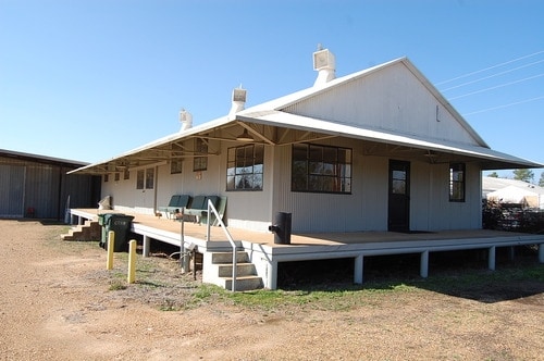
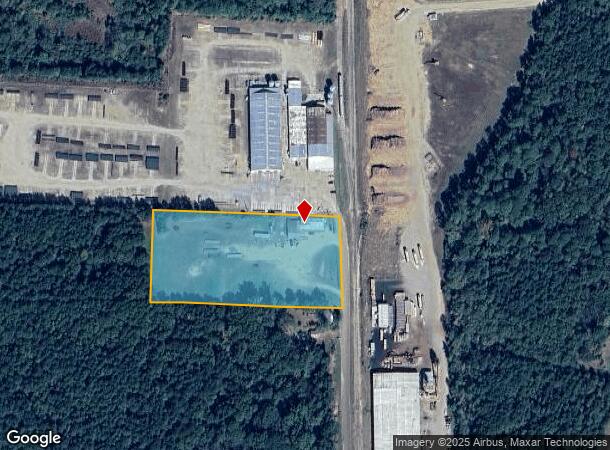
Property Record
2210 Duracrete, Magnolia, AR 71753
NEARBY LISTINGS FOR SALE OR LEASE
-
-
View all Magnolia listings for sale on LoopNet.com
Property Detail
2210 Duracrete
01-01081-00000
Magnolia 23-17-21
Warehouse
4AC NE SE BOOK 283 PAGE 216 2210 DURACRETE COMMENCING AT THE NORTHWEST CORNER OF THE NE 1/4 SE 1/4 OF SECTION 23, TOWNSHIP 17
X
Columbia
05027C0325C
Arkansas
2025
4 AC
2025
Arkansas South Area
950500
Other Market Areas
2,100 SF
Magnolia, AR
DEMOGRAPHICS near 2210 Duracrete
1 Mile
3 Mile
5 Mile
2024 Total Population
622
8,365
13,711
2029 Population
637
8,334
13,514
Pop Growth 2024-2029
+ 2.41%
(0.37%)
(1.44%)
Average Age
36
38
37
2024 Total Households
255
3,728
5,298
HH Growth 2024-2029
+ 2.75%
(0.32%)
(1.06%)
Median Household Inc
$26,704
$31,669
$36,283
Avg Household Size
2.40
2.20
2.20
2024 Avg HH Vehicles
2.00
2.00
2.00
Median Home Value
$90,983
$115,535
$135,806
Median Year Built
1978
1970
1973
Nearby Places
Map Layers
Map Styles
 Street
 Aerial
- Restaurants
- Banks
- Shops
- Fitness
- Groceries
Nearby Properties
Address
Land Use
TOTAL SIZE
Lot Size
Zoning
Address
Land Use
TOTAL SIZE
Lot Size
Zoning
432,882 SF
16.37 AC
Address
Land Use
TOTAL SIZE
Lot Size
Zoning
156,106 SF
17.99 AC
Address
Land Use
TOTAL SIZE
Lot Size
Zoning
37,516 SF
1.69 AC
Address
Land Use
TOTAL SIZE
Lot Size
Zoning
4,600 SF
10.50 AC
Address
Land Use
TOTAL SIZE
Lot Size
Zoning
109,820 SF
13.67 AC
Address
Land Use
TOTAL SIZE
Lot Size
Zoning
25,848 SF
0.57 AC
Address
Land Use
TOTAL SIZE
Lot Size
Zoning
33,104 SF
2 AC
Address
Land Use
TOTAL SIZE
Lot Size
Zoning
40,496 SF
Address
Land Use
TOTAL SIZE
Lot Size
Zoning
2,172 SF
6.36 AC
Address
Land Use
TOTAL SIZE
Lot Size
Zoning
65,394 SF
6.98 AC
Address
Land Use
TOTAL SIZE
Lot Size
Zoning
67,332 SF
3.45 AC
Address
Land Use
TOTAL SIZE
Lot Size
Zoning
282,499 SF
9.08 AC
Address
Land Use
TOTAL SIZE
Lot Size
Zoning
74,783 SF
7.26 AC
Address
Land Use
TOTAL SIZE
Lot Size
Zoning
35,680 SF
2.82 AC
Address
Land Use
TOTAL SIZE
Lot Size
Zoning
43,913 SF
2.40 AC
Address
Land Use
TOTAL SIZE
Lot Size
Zoning
20,024 SF
2.95 AC
Address
Land Use
TOTAL SIZE
Lot Size
Zoning
1,288 SF
9.25 AC
Address
Land Use
TOTAL SIZE
Lot Size
Zoning
9,320 SF
7.08 AC
Address
Land Use
TOTAL SIZE
Lot Size
Zoning
55,580 SF
2.29 AC
Address
Land Use
TOTAL SIZE
Lot Size
Zoning
14,796 SF
0.82 AC
Address
Land Use
TOTAL SIZE
Lot Size
Zoning
118,818 SF
7.88 AC
Address
Land Use
TOTAL SIZE
Lot Size
Zoning
14,980 SF
1.76 AC
Address
Land Use
TOTAL SIZE
Lot Size
Zoning
31,702 SF
1.55 AC
Address
Land Use
TOTAL SIZE
Lot Size
Zoning
35,292 SF
Address
Land Use
TOTAL SIZE
Lot Size
Zoning
8,361 SF
5.32 AC
Address
Land Use
TOTAL SIZE
Lot Size
Zoning
7,453 SF
3.01 AC
Address
Land Use
TOTAL SIZE
Lot Size
Zoning
5,870 SF
1.33 AC
Address
Land Use
TOTAL SIZE
Lot Size
Zoning
54,560 SF
7.89 AC
Address
Land Use
TOTAL SIZE
Lot Size
Zoning
16,442 SF
2.40 AC
Address
Land Use
TOTAL SIZE
Lot Size
Zoning
17,577 SF
2.20 AC
The World's #1 Commercial Real Estate Marketplace
Connect with us
© 2026 CoStar Group
The information above has been obtained from sources believed reliable. While we do not doubt its accuracy we have not verified it and make no guarantee, warranty or representation about it. It is your responsibility to independently confirm its accuracy and completeness. Any projections, opinions, assumptions, or estimates used are for example only and do not represent the current or future performance of the property. The value of this transaction to you depends on tax and other factors which should be evaluated by your tax, financial, and legal advisors. You and your advisors should conduct a careful, independent investigation of the property to determine to your satisfaction the suitability of the property for your needs.