Property Record
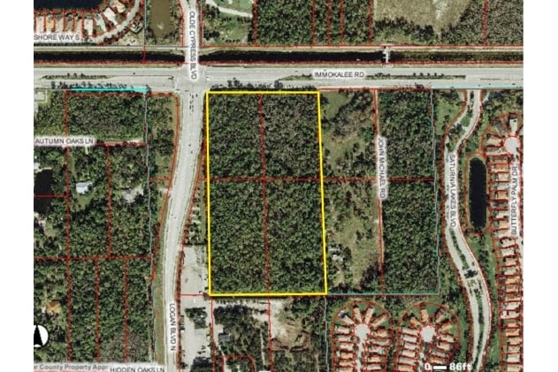
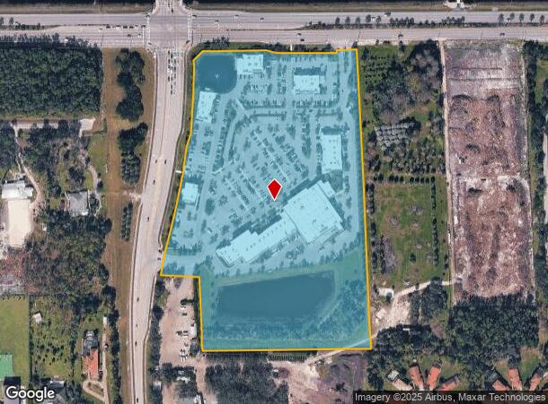
2210 Logan Blvd N, Naples, FL 34119
NEARBY LISTINGS FOR SALE OR LEASE
Property Detail
2210 Logan Blvd N
00194880000
Acreage Header
Regionalshoppingcenterormallwithanchorstore
28 48 26 E1/2 OF SW1/4 OF NW1/4 OF NW1/4 5 AC OR 1189 PG 2052, W1/2 OF NW1/4 OF NW1/4 OF NW1/4 LESS N 150FT HWY R/W LESS ORDER OF TAKING DESC IN OR 3888 PG 1618, LESS PORT OF LYING W OF R/W DESC IN ORDER OR 3888 1618, AND E1/2 0F NW 1/4 OF NW1/4 OF N
AH
Collier
12021C0213H
Florida
2024
18.57 AC
2025
North Naples
010435
Southwest Florida
86,254 SF
Naples-Immokalee-Marco Island, FL
DEMOGRAPHICS near 2210 Logan Blvd N
1 Mile
3 Mile
5 Mile
2024 Total Population
5,113
50,267
106,606
2029 Population
5,676
56,453
121,268
Pop Growth 2024-2029
+ 11.01%
+ 12.31%
+ 13.75%
Average Age
46
46
49
2024 Total Households
2,038
20,752
45,796
HH Growth 2024-2029
+ 10.40%
+ 11.86%
+ 13.53%
Median Household Inc
$103,915
$81,340
$87,469
Avg Household Size
2.40
2.30
2.20
2024 Avg HH Vehicles
2.00
2.00
2.00
Median Home Value
$507,754
$474,919
$472,559
Median Year Built
2004
2004
2002
Nearby Places
Map Layers
Map Styles
 Street
 Aerial
- Restaurants
- Banks
- Shops
- Fitness
- Groceries
PUBLIC TRANSPORTATION
AIRPORT
Southwest Florida International
DRIVE
WALK
Distance
Southwest Florida International
32 min
24.3 mi
Freight Ports
Port Everglades
DRIVE
WALK
Distance
Port Everglades
124 min
111.3 mi
Nearby Properties
Address
Land Use
TOTAL SIZE
Lot Size
Zoning
Address
Land Use
TOTAL SIZE
Lot Size
Zoning
465,208 SF
17.72 AC
Address
Land Use
TOTAL SIZE
Lot Size
Zoning
463,985 SF
28.48 AC
Address
Land Use
TOTAL SIZE
Lot Size
Zoning
312,140 SF
15 AC
Address
Land Use
TOTAL SIZE
Lot Size
Zoning
275,219 SF
16.20 AC
Address
Land Use
TOTAL SIZE
Lot Size
Zoning
110,908 SF
210.45 AC
A
Address
Land Use
TOTAL SIZE
Lot Size
Zoning
413,313 SF
48.48 AC
PUD
Address
Land Use
TOTAL SIZE
Lot Size
Zoning
376,493 SF
65.03 AC
RSF-3
Address
Land Use
TOTAL SIZE
Lot Size
Zoning
353,756 SF
23.26 AC
ROAD
Address
Land Use
TOTAL SIZE
Lot Size
Zoning
426,074 SF
23.25 AC
PUD
Address
Land Use
TOTAL SIZE
Lot Size
Zoning
192,347 SF
7.84 AC
PUD
Address
Land Use
TOTAL SIZE
Lot Size
Zoning
188,741 SF
9.04 AC
A
Address
Land Use
TOTAL SIZE
Lot Size
Zoning
52,982 SF
10.58 AC
Address
Land Use
TOTAL SIZE
Lot Size
Zoning
329,031 SF
20 AC
A
Address
Land Use
TOTAL SIZE
Lot Size
Zoning
142,737 SF
37.48 AC
A
Address
Land Use
TOTAL SIZE
Lot Size
Zoning
41,465 SF
3.36 AC
PUD
Address
Land Use
TOTAL SIZE
Lot Size
Zoning
115,552 SF
13.20 AC
PUD
Address
Land Use
TOTAL SIZE
Lot Size
Zoning
104,470 SF
13.06 AC
PUD
Address
Land Use
TOTAL SIZE
Lot Size
Zoning
22,099 SF
7.73 AC
PUD
Address
Land Use
TOTAL SIZE
Lot Size
Zoning
113,867 SF
6.90 AC
PUD
Address
Land Use
TOTAL SIZE
Lot Size
Zoning
209,373 SF
23.76 AC
PUD
Address
Land Use
TOTAL SIZE
Lot Size
Zoning
52,370 SF
7.82 AC
PUD
Address
Land Use
TOTAL SIZE
Lot Size
Zoning
54,140 SF
50.66 AC
PUD
Address
Land Use
TOTAL SIZE
Lot Size
Zoning
175,337 SF
14.61 AC
MPUD
Address
Land Use
TOTAL SIZE
Lot Size
Zoning
46,820 SF
7.02 AC
PUD
Address
Land Use
TOTAL SIZE
Lot Size
Zoning
75,307 SF
2.49 AC
Address
Land Use
TOTAL SIZE
Lot Size
Zoning
81,202 SF
183.18 AC
GC
Address
Land Use
TOTAL SIZE
Lot Size
Zoning
39,728 SF
5.74 AC
Address
Land Use
TOTAL SIZE
Lot Size
Zoning
61,688 SF
2.65 AC
Address
Land Use
TOTAL SIZE
Lot Size
Zoning
59,616 SF
2.51 AC
The World's #1 Commercial Real Estate Marketplace
Connect with us
© 2025 CoStar Group
The information above has been obtained from sources believed reliable. While we do not doubt its accuracy we have not verified it and make no guarantee, warranty or representation about it. It is your responsibility to independently confirm its accuracy and completeness. Any projections, opinions, assumptions, or estimates used are for example only and do not represent the current or future performance of the property. The value of this transaction to you depends on tax and other factors which should be evaluated by your tax, financial, and legal advisors. You and your advisors should conduct a careful, independent investigation of the property to determine to your satisfaction the suitability of the property for your needs.