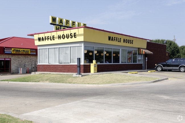
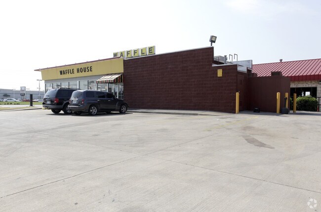
Property Record
2210 N Aspen Ave, Broken Arrow, OK 74012

NEARBY LISTINGS FOR SALE OR LEASE
Property Detail
2210 N Aspen Ave
Tulsa, OK
Dobbs Park
83520-84-04-16189
PRT LT 2 BEG 75S NEC TH S100 W240 N100 E240 POB BLK 1
Restaurantbuilding
Tulsa
X
Oklahoma
40143C0379L
2
2025
0.55 AC
2025
Southeast Tulsa
007409
Tulsa
1,620 SF
DEMOGRAPHICS near 2210 N Aspen Ave
1 Mile
3 Mile
5 Mile
2024 Total Population
4,527
72,577
204,550
2029 Population
4,657
74,697
213,179
Pop Growth 2024-2029
+ 2.87%
+ 2.92%
+ 4.22%
Average Age
37
37
37
2024 Total Households
1,888
27,871
78,895
HH Growth 2024-2029
+ 2.91%
+ 3.01%
+ 4.17%
Median Household Inc
$67,005
$67,852
$63,593
Avg Household Size
2.30
2.50
2.50
2024 Avg HH Vehicles
2.00
2.00
2.00
Median Home Value
$227,130
$198,454
$178,706
Median Year Built
2000
1990
1985
Nearby Places
Map Layers
Map Styles
 Street
 Aerial
- Restaurants
- Banks
- Shops
- Fitness
- Groceries
PUBLIC TRANSPORTATION
AIRPORT
Tulsa International
DRIVE
WALK
Distance
Tulsa International
21 min
14.5 mi
Freight Ports
Tulsa Port Of Catoosa
DRIVE
WALK
Distance
Tulsa Port Of Catoosa
24 min
18.3 mi
Nearby Properties
Address
Land Use
TOTAL SIZE
Lot Size
Zoning
Address
Land Use
TOTAL SIZE
Lot Size
Zoning
197,676 SF
13.38 AC
CH
Address
Land Use
TOTAL SIZE
Lot Size
Zoning
80,431 SF
9.51 AC
IL
Address
Land Use
TOTAL SIZE
Lot Size
Zoning
184,679 SF
33.97 AC
AG
Address
Land Use
TOTAL SIZE
Lot Size
Zoning
435,822 SF
43.42 AC
R1
Address
Land Use
TOTAL SIZE
Lot Size
Zoning
304,789 SF
40.82 AC
CO
Address
Land Use
TOTAL SIZE
Lot Size
Zoning
78,119 SF
11.11 AC
CO
Address
Land Use
TOTAL SIZE
Lot Size
Zoning
115,003 SF
59.09 AC
CG
Address
Land Use
TOTAL SIZE
Lot Size
Zoning
125,902 SF
19.15 AC
CH
Address
Land Use
TOTAL SIZE
Lot Size
Zoning
59,108 SF
11.18 AC
R3
Address
Land Use
TOTAL SIZE
Lot Size
Zoning
53,139 SF
108.91 AC
A1
Address
Land Use
TOTAL SIZE
Lot Size
Zoning
55,283 SF
39.50 AC
SR
Address
Land Use
TOTAL SIZE
Lot Size
Zoning
84,927 SF
4.81 AC
RM2
Address
Land Use
TOTAL SIZE
Lot Size
Zoning
75,444 SF
23.92 AC
R1
Address
Land Use
TOTAL SIZE
Lot Size
Zoning
58,695 SF
5.34 AC
RM
Address
Land Use
TOTAL SIZE
Lot Size
Zoning
117,537 SF
14.99 AC
CO
Address
Land Use
TOTAL SIZE
Lot Size
Zoning
77,260 SF
0.58 AC
R3
Address
Land Use
TOTAL SIZE
Lot Size
Zoning
49,113 SF
5.42 AC
R3
Address
Land Use
TOTAL SIZE
Lot Size
Zoning
222,768 SF
20.24 AC
CS
Address
Land Use
TOTAL SIZE
Lot Size
Zoning
57,630 SF
35.09 AC
IL
Address
Land Use
TOTAL SIZE
Lot Size
Zoning
33,332 SF
2.92 AC
CO
Address
Land Use
TOTAL SIZE
Lot Size
Zoning
68,478 SF
9.27 AC
R1
Address
Land Use
TOTAL SIZE
Lot Size
Zoning
67,149 SF
28.56 AC
R2
Address
Land Use
TOTAL SIZE
Lot Size
Zoning
58,627 SF
6.07 AC
CG
Address
Land Use
TOTAL SIZE
Lot Size
Zoning
363,154 SF
23.09 AC
IL
Address
Land Use
TOTAL SIZE
Lot Size
Zoning
71,362 SF
14.08 AC
RD
Address
Land Use
TOTAL SIZE
Lot Size
Zoning
279,517 SF
25.43 AC
CO
Address
Land Use
TOTAL SIZE
Lot Size
Zoning
60,790 SF
10.84 AC
R1
Address
Land Use
TOTAL SIZE
Lot Size
Zoning
248,722 SF
15.01 AC
RM
Address
Land Use
TOTAL SIZE
Lot Size
Zoning
94,348 SF
11.21 AC
CO
Address
Land Use
TOTAL SIZE
Lot Size
Zoning
268,496 SF
19.31 AC
CN
The World's #1 Commercial Real Estate Marketplace
Connect with us
© 2025 CoStar Group
The information above has been obtained from sources believed reliable. While we do not doubt its accuracy we have not verified it and make no guarantee, warranty or representation about it. It is your responsibility to independently confirm its accuracy and completeness. Any projections, opinions, assumptions, or estimates used are for example only and do not represent the current or future performance of the property. The value of this transaction to you depends on tax and other factors which should be evaluated by your tax, financial, and legal advisors. You and your advisors should conduct a careful, independent investigation of the property to determine to your satisfaction the suitability of the property for your needs.