Property Record
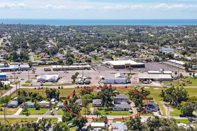
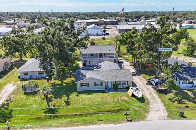
2210 Park Rd, Venice, FL 34293
This Property Is For Sale
NEARBY LISTINGS FOR SALE OR LEASE
Property Detail
2210 Park Rd
North Port-Sarasota-Bradenton, FL
Venice Groves
0450-10-0021
Sarasota
Duplex
Florida
X
0.16 AC
12115C0341G
Venice/Englewood
1,599 SF
Tampa/St Petersburg
DEMOGRAPHICS near 2210 Park Rd
1 Mile
3 Mile
5 Mile
2024 Total Population
8,127
45,222
94,631
2029 Population
8,526
48,188
102,073
Pop Growth 2024-2029
+ 4.91%
+ 6.56%
+ 7.86%
Average Age
49
57
59
2024 Total Households
3,774
22,255
47,550
HH Growth 2024-2029
+ 4.80%
+ 6.67%
+ 7.91%
Median Household Inc
$72,603
$75,028
$77,839
Avg Household Size
2.10
2.00
1.90
2024 Avg HH Vehicles
2.00
2.00
2.00
Median Home Value
$333,920
$381,328
$433,689
Median Year Built
1988
1987
1991
Nearby Places
Map Layers
Map Styles
 Street
 Aerial
- Restaurants
- Banks
- Shops
- Fitness
- Groceries
PUBLIC TRANSPORTATION
AIRPORT
Sarasota/Bradenton International
DRIVE
WALK
Distance
Sarasota/Bradenton International
50 min
27.5 mi
Punta Gorda
DRIVE
WALK
Distance
Punta Gorda
50 min
38.2 mi
Freight Ports
Port Manatee
DRIVE
WALK
Distance
Port Manatee
62 min
45.8 mi
Nearby Properties
Address
Land Use
TOTAL SIZE
Lot Size
Zoning
Address
Land Use
TOTAL SIZE
Lot Size
Zoning
565,625 SF
15.61 AC
ST2A
Address
Land Use
TOTAL SIZE
Lot Size
Zoning
251,872 SF
25.01 AC
RMF2
Address
Land Use
TOTAL SIZE
Lot Size
Zoning
191,373 SF
23.12 AC
RMF2
Address
Land Use
TOTAL SIZE
Lot Size
Zoning
173,966 SF
17 AC
CG
Address
Land Use
TOTAL SIZE
Lot Size
Zoning
149,834 SF
36.95 AC
GU
Address
Land Use
TOTAL SIZE
Lot Size
Zoning
223,397 SF
453.78 AC
G
Address
Land Use
TOTAL SIZE
Lot Size
Zoning
159,759 SF
12.60 AC
RMF3
Address
Land Use
TOTAL SIZE
Lot Size
Zoning
201,992 SF
22.45 AC
CG
Address
Land Use
TOTAL SIZE
Lot Size
Zoning
85,177 SF
68.01 AC
RE1
Address
Land Use
TOTAL SIZE
Lot Size
Zoning
146,990 SF
8.90 AC
CG
Address
Land Use
TOTAL SIZE
Lot Size
Zoning
98,113 SF
12.05 AC
CSC
Address
Land Use
TOTAL SIZE
Lot Size
Zoning
111,306 SF
9.35 AC
CSC
Address
Land Use
TOTAL SIZE
Lot Size
Zoning
138,547 SF
18.63 AC
CSC
Address
Land Use
TOTAL SIZE
Lot Size
Zoning
66,899 SF
30.10 AC
GU
Address
Land Use
TOTAL SIZE
Lot Size
Zoning
121,747 SF
17.54 AC
OUE1
Address
Land Use
TOTAL SIZE
Lot Size
Zoning
112,415 SF
8.77 AC
CSC
Address
Land Use
TOTAL SIZE
Lot Size
Zoning
66.78 AC
RMF1
Address
Land Use
TOTAL SIZE
Lot Size
Zoning
92,802 SF
4.78 AC
CN
Address
Land Use
TOTAL SIZE
Lot Size
Zoning
101,496 SF
19.08 AC
CG
Address
Land Use
TOTAL SIZE
Lot Size
Zoning
119,222 SF
12.47 AC
CG
Address
Land Use
TOTAL SIZE
Lot Size
Zoning
94,453 SF
10.11 AC
CG
Address
Land Use
TOTAL SIZE
Lot Size
Zoning
79,048 SF
6.92 AC
CI
Address
Land Use
TOTAL SIZE
Lot Size
Zoning
114,693 SF
15.16 AC
PUD
Address
Land Use
TOTAL SIZE
Lot Size
Zoning
121,850 SF
8.98 AC
CG
Address
Land Use
TOTAL SIZE
Lot Size
Zoning
61,332 SF
8.25 AC
ST2
Address
Land Use
TOTAL SIZE
Lot Size
Zoning
109,350 SF
4.17 AC
CI
Address
Land Use
TOTAL SIZE
Lot Size
Zoning
90,484 SF
4.35 AC
CG
Address
Land Use
TOTAL SIZE
Lot Size
Zoning
56,899 SF
5.89 AC
OPI
Address
Land Use
TOTAL SIZE
Lot Size
Zoning
28,739 SF
4.89 AC
ST2
Address
Land Use
TOTAL SIZE
Lot Size
Zoning
23,517 SF
360.01 AC
RSF3
The World's #1 Commercial Real Estate Marketplace
Connect with us
© 2025 CoStar Group
The information above has been obtained from sources believed reliable. While we do not doubt its accuracy we have not verified it and make no guarantee, warranty or representation about it. It is your responsibility to independently confirm its accuracy and completeness. Any projections, opinions, assumptions, or estimates used are for example only and do not represent the current or future performance of the property. The value of this transaction to you depends on tax and other factors which should be evaluated by your tax, financial, and legal advisors. You and your advisors should conduct a careful, independent investigation of the property to determine to your satisfaction the suitability of the property for your needs.