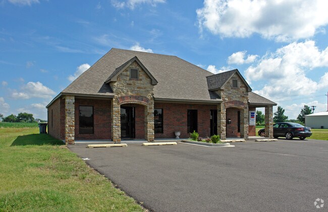
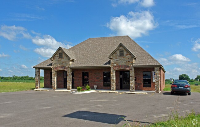
Property Record
2210 W State Highway 51, Wagoner, OK 74467

Save to a Folder
{{folder.Name}}
{{folder.ListingIds.length}} Properties
{{folder.ListingIds.length}} Property
Create a New Folder
Property Detail
2210 W State Highway 51
730078310
08-17-18 A TR OF LAND SIT IN THE SE MORE PART DESC AS FOLLOWS: COMM AT THE SE COR OF SD SE -N01D52'16" W 174.49' TO A PT ON T
Officebuilding
WAGONER
B and X Area of moderate flood hazard, usually the area between the limits of the 100-year and 500-year floods.
Oklahoma
2025
0.51 AC
2025
Wagoner County
030300
Tulsa
2,000 SF
Tulsa, OK
NEARBY LISTINGS FOR SALE OR LEASE
-
-
View all Wagoner listings for sale on LoopNet.com
DEMOGRAPHICS near 2210 W State Highway 51
1 mile
3 mile
5 mile
2025 Total Population
2,022
9,919
11,140
2030 Population
2,217
10,910
12,258
Pop Growth 2025-2030
+ 9.64%
+ 9.99%
+ 10.04%
Average Age
41
40
41
2025 Total Households
806
3,801
4,306
HH Growth 2025-2030
+ 9.31%
+ 9.73%
+ 9.75%
Median Household Inc
$55,094
$58,766
$58,417
Avg Household Size
2.50
2.50
2.50
2025 Avg HH Vehicles
2.00
2.00
2.00
Median Home Value
$164,603
$160,657
$164,069
Median Year Built
1982
1977
1978
Nearby Places
Map Layers
Map Styles
 Street
 Aerial
Layers
 Traffic
 Biking
Places
Listings with unknown addresses are not visible on the map
- Restaurants
- Banks
- Shops
- Fitness
- Groceries
Nearby Properties
Address
Land Use
TOTAL SIZE
Lot Size
Zoning
Address
Land Use
TOTAL SIZE
Lot Size
Zoning
440 SF
94.70 AC
Address
Land Use
TOTAL SIZE
Lot Size
Zoning
28,180 SF
2.67 AC
Address
Land Use
TOTAL SIZE
Lot Size
Zoning
103,625 SF
11.58 AC
Address
Land Use
TOTAL SIZE
Lot Size
Zoning
110,000 SF
Address
Land Use
TOTAL SIZE
Lot Size
Zoning
6,412 SF
0.37 AC
Address
Land Use
TOTAL SIZE
Lot Size
Zoning
1,600 SF
5.28 AC
Address
Land Use
TOTAL SIZE
Lot Size
Zoning
6,436 SF
8.72 AC
Address
Land Use
TOTAL SIZE
Lot Size
Zoning
4,500 SF
1.29 AC
Address
Land Use
TOTAL SIZE
Lot Size
Zoning
20,210 SF
4.22 AC
Address
Land Use
TOTAL SIZE
Lot Size
Zoning
9,890 SF
0.31 AC
Address
Land Use
TOTAL SIZE
Lot Size
Zoning
14,981 SF
1.43 AC
Address
Land Use
TOTAL SIZE
Lot Size
Zoning
4,500 SF
11.50 AC
Address
Land Use
TOTAL SIZE
Lot Size
Zoning
9,280 SF
0.32 AC
Address
Land Use
TOTAL SIZE
Lot Size
Zoning
5,400 SF
3.07 AC
Address
Land Use
TOTAL SIZE
Lot Size
Zoning
Address
Land Use
TOTAL SIZE
Lot Size
Zoning
54,280 SF
5.28 AC
Address
Land Use
TOTAL SIZE
Lot Size
Zoning
800 SF
2.98 AC
Address
Land Use
TOTAL SIZE
Lot Size
Zoning
2,232 SF
7.77 AC
Address
Land Use
TOTAL SIZE
Lot Size
Zoning
4,638 SF
0.92 AC
Address
Land Use
TOTAL SIZE
Lot Size
Zoning
Address
Land Use
TOTAL SIZE
Lot Size
Zoning
3,000 SF
1.89 AC
Address
Land Use
TOTAL SIZE
Lot Size
Zoning
Address
Land Use
TOTAL SIZE
Lot Size
Zoning
1,400 SF
3.84 AC
Address
Land Use
TOTAL SIZE
Lot Size
Zoning
2,150 SF
1.16 AC
Address
Land Use
TOTAL SIZE
Lot Size
Zoning
5,249 SF
1.16 AC
Address
Land Use
TOTAL SIZE
Lot Size
Zoning
4,026 SF
1.80 AC
Address
Land Use
TOTAL SIZE
Lot Size
Zoning
4,968 SF
1.03 AC
Address
Land Use
TOTAL SIZE
Lot Size
Zoning
2,444 SF
1.15 AC
The World's #1 Commercial Real Estate Marketplace
Connect with us
© 2026 CoStar Group
The information above has been obtained from sources believed reliable. While we do not doubt its accuracy we have not verified it and make no guarantee, warranty or representation about it. It is your responsibility to independently confirm its accuracy and completeness. Any projections, opinions, assumptions, or estimates used are for example only and do not represent the current or future performance of the property. The value of this transaction to you depends on tax and other factors which should be evaluated by your tax, financial, and legal advisors. You and your advisors should conduct a careful, independent investigation of the property to determine to your satisfaction the suitability of the property for your needs.