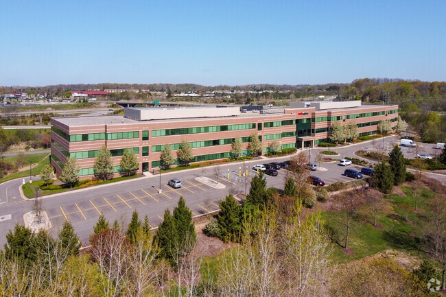
Property Record
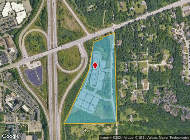
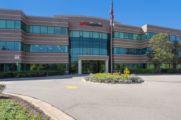
2211 Old Earhart Rd, Ann Arbor, MI 48105

Current Lease Availabilities
NEARBY LISTINGS FOR SALE OR LEASE
Property Detail
2211 Old Earhart Rd
09-14-480-005
TRF 06-25-97 *OLD SID - I 09-014-011-00 14-16B BEG AT SE COR OF SEC, TH S 89 DEG 21' 48 W 973.49 FT IN S LINE OF SEC
Commercialnec
Washtenaw
X
Michigan
26161C0266E
22.84 AC
2025
Washtenaw E of 23
2025
Detroit
406000
Ann Arbor, MI
202,219 SF
DEMOGRAPHICS near 2211 Old Earhart Rd
1 Mile
3 Mile
5 Mile
2024 Total Population
4,241
39,415
133,794
2029 Population
4,175
39,307
132,425
Pop Growth 2024-2029
(1.56%)
(0.27%)
(1.02%)
Average Age
40
37
35
2024 Total Households
1,945
15,641
54,318
HH Growth 2024-2029
(1.75%)
(0.12%)
(1.01%)
Median Household Inc
$83,552
$81,465
$69,635
Avg Household Size
2.10
2.20
2.10
2024 Avg HH Vehicles
2.00
1.00
2.00
Median Home Value
$391,015
$452,673
$407,861
Median Year Built
1973
1981
1972
Nearby Places
Map Layers
Map Styles
 Street
 Aerial
- Restaurants
- Banks
- Shops
- Fitness
- Groceries
PUBLIC TRANSPORTATION
COMMUTER RAIL
DRIVE
WALK
Distance
11 min
6.7 mi
AIRPORT
Detroit Metro Wayne County
DRIVE
WALK
Distance
Detroit Metro Wayne County
40 min
29.0 mi
Nearby Properties
Address
Land Use
TOTAL SIZE
Lot Size
Zoning
Address
Land Use
TOTAL SIZE
Lot Size
Zoning
358,683 SF
5.42 AC
PUD
Address
Land Use
TOTAL SIZE
Lot Size
Zoning
401,491 SF
3.12 AC
C1A/R
Address
Land Use
TOTAL SIZE
Lot Size
Zoning
2,668 SF
31.60 AC
PUD
Address
Land Use
TOTAL SIZE
Lot Size
Zoning
524,946 SF
10.43 AC
PUD
Address
Land Use
TOTAL SIZE
Lot Size
Zoning
301,086 SF
21.41 AC
R4A
Address
Land Use
TOTAL SIZE
Lot Size
Zoning
323,630 SF
21.55 AC
UNKNOWN
Address
Land Use
TOTAL SIZE
Lot Size
Zoning
249,612 SF
1.87 AC
C1A/R
Address
Land Use
TOTAL SIZE
Lot Size
Zoning
324,832 SF
18.81 AC
R4A
Address
Land Use
TOTAL SIZE
Lot Size
Zoning
273,440 SF
73.06 AC
RRA
Address
Land Use
TOTAL SIZE
Lot Size
Zoning
208,890 SF
A-1
Address
Land Use
TOTAL SIZE
Lot Size
Zoning
219,322 SF
19.82 AC
R4D
Address
Land Use
TOTAL SIZE
Lot Size
Zoning
114,208 SF
8.63 AC
PUD
Address
Land Use
TOTAL SIZE
Lot Size
Zoning
5,416 SF
30.14 AC
R-9
Address
Land Use
TOTAL SIZE
Lot Size
Zoning
919,507 SF
17.53 AC
OP
Address
Land Use
TOTAL SIZE
Lot Size
Zoning
919,507 SF
20.95 AC
OP
Address
Land Use
TOTAL SIZE
Lot Size
Zoning
340,425 SF
31.50 AC
R4B
Address
Land Use
TOTAL SIZE
Lot Size
Zoning
919,507 SF
15.40 AC
RC
Address
Land Use
TOTAL SIZE
Lot Size
Zoning
919,507 SF
16.06 AC
OP
Address
Land Use
TOTAL SIZE
Lot Size
Zoning
163,812 SF
6.96 AC
R4D
Address
Land Use
TOTAL SIZE
Lot Size
Zoning
192,963 SF
21.19 AC
R4A
Address
Land Use
TOTAL SIZE
Lot Size
Zoning
222,022 SF
11.21 AC
R4A
Address
Land Use
TOTAL SIZE
Lot Size
Zoning
110,389 SF
16.04 AC
RRA
Address
Land Use
TOTAL SIZE
Lot Size
Zoning
147,200 SF
16.58 AC
RE
Address
Land Use
TOTAL SIZE
Lot Size
Zoning
166,092 SF
12.63 AC
R4A
Address
Land Use
TOTAL SIZE
Lot Size
Zoning
128,525 SF
12.36 AC
C3
Address
Land Use
TOTAL SIZE
Lot Size
Zoning
79,500 SF
8.82 AC
PUD
Address
Land Use
TOTAL SIZE
Lot Size
Zoning
90,546 SF
12.57 AC
ORL
Address
Land Use
TOTAL SIZE
Lot Size
Zoning
147,696 SF
11.71 AC
R4A
Address
Land Use
TOTAL SIZE
Lot Size
Zoning
128,920 SF
10.10 AC
R4B
The World's #1 Commercial Real Estate Marketplace
Connect with us
© 2026 CoStar Group
The information above has been obtained from sources believed reliable. While we do not doubt its accuracy we have not verified it and make no guarantee, warranty or representation about it. It is your responsibility to independently confirm its accuracy and completeness. Any projections, opinions, assumptions, or estimates used are for example only and do not represent the current or future performance of the property. The value of this transaction to you depends on tax and other factors which should be evaluated by your tax, financial, and legal advisors. You and your advisors should conduct a careful, independent investigation of the property to determine to your satisfaction the suitability of the property for your needs.