Property Record
2211 Station Rd, North Chesterfield, VA 23234

NEARBY LISTINGS FOR SALE OR LEASE
Property Detail
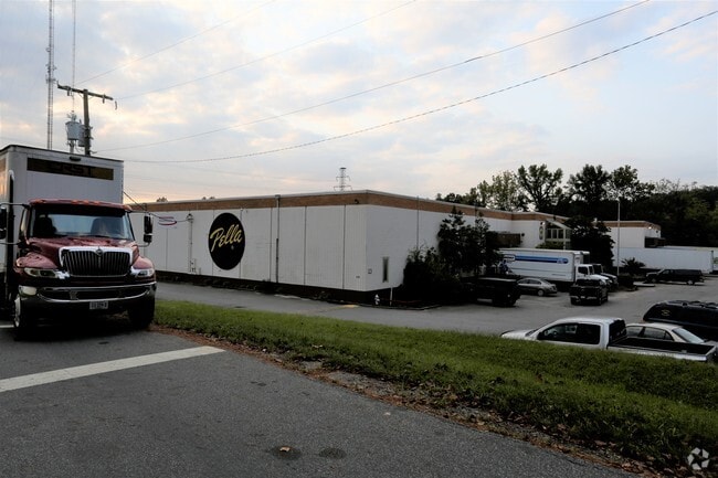
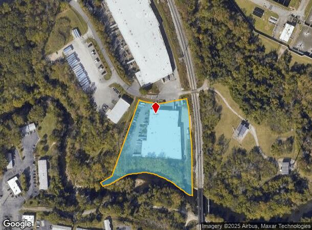
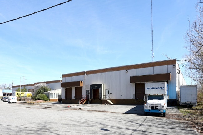
2211 Station Rd
792-68-50-74-100-000
Falling Creek Parcel F
Industrialgeneral
FALLING CREEK PAR F
AE
Chesterfield
5101290083E
Virginia
2025
4.20 AC
2025
Jeff Davis Corridor
100300
Richmond VA
59,808 SF
Richmond, VA
DEMOGRAPHICS near 2211 Station Rd
1 Mile
3 Mile
5 Mile
2024 Total Population
4,796
37,449
122,590
2029 Population
5,238
40,432
130,646
Pop Growth 2024-2029
+ 9.22%
+ 7.97%
+ 6.57%
Average Age
35
38
38
2024 Total Households
1,784
13,578
45,047
HH Growth 2024-2029
+ 9.30%
+ 8.04%
+ 6.59%
Median Household Inc
$38,967
$52,306
$56,425
Avg Household Size
2.60
2.70
2.60
2024 Avg HH Vehicles
2.00
2.00
2.00
Median Home Value
$149,267
$224,654
$226,227
Median Year Built
1969
1975
1978
Nearby Places
Map Layers
Map Styles
 Street
 Aerial
- Restaurants
- Banks
- Shops
- Fitness
- Groceries
PUBLIC TRANSPORTATION
COMMUTER RAIL
Richmond Main Street Amtrak Station (Northeast Regional - Amtrak)
DRIVE
WALK
Distance
Richmond Main Street Amtrak Station (Northeast Regional - Amtrak)
14 min
7.4 mi
AIRPORT
Richmond International
DRIVE
WALK
Distance
Richmond International
20 min
12.2 mi
Freight Ports
Virginia Port Authority - Richmond
DRIVE
WALK
Distance
Virginia Port Authority - Richmond
10 min
4.7 mi
Nearby Properties
Address
Land Use
TOTAL SIZE
Lot Size
Zoning
Address
Land Use
TOTAL SIZE
Lot Size
Zoning
543,477 SF
142.90 AC
MULTIPLE Z
Address
Land Use
TOTAL SIZE
Lot Size
Zoning
100 SF
652.52 AC
A - AGRICU
Address
Land Use
TOTAL SIZE
Lot Size
Zoning
73,867 SF
54.52 AC
R7 - SINGL
Address
Land Use
TOTAL SIZE
Lot Size
Zoning
231,168 SF
57.31 AC
R7 - SINGL
Address
Land Use
TOTAL SIZE
Lot Size
Zoning
413.51 AC
I3 - HVY I
Address
Land Use
TOTAL SIZE
Lot Size
Zoning
406,110 SF
57.69 AC
I3 - HVY I
Address
Land Use
TOTAL SIZE
Lot Size
Zoning
462,732 SF
24.94 AC
M-2 HEAVY
Address
Land Use
TOTAL SIZE
Lot Size
Zoning
448,888 SF
35.33 AC
M-2 HEAVY
Address
Land Use
TOTAL SIZE
Lot Size
Zoning
306,439 SF
48.81 AC
M-2 HEAVY
Address
Land Use
TOTAL SIZE
Lot Size
Zoning
290,200 SF
50.99 AC
R7 - SINGL
Address
Land Use
TOTAL SIZE
Lot Size
Zoning
320,853 SF
33.68 AC
I3 - HVY I
Address
Land Use
TOTAL SIZE
Lot Size
Zoning
220,825 SF
55.17 AC
I3 - HVY I
Address
Land Use
TOTAL SIZE
Lot Size
Zoning
406,490 SF
19.58 AC
I3 - HVY I
Address
Land Use
TOTAL SIZE
Lot Size
Zoning
406,490 SF
33.22 AC
I3 - HVY I
Address
Land Use
TOTAL SIZE
Lot Size
Zoning
23,586 SF
41.23 AC
I2 - GEN I
Address
Land Use
TOTAL SIZE
Lot Size
Zoning
100 SF
15.43 AC
RMF - RES,
Address
Land Use
TOTAL SIZE
Lot Size
Zoning
326,015 SF
51.99 AC
M-2 HEAVY
Address
Land Use
TOTAL SIZE
Lot Size
Zoning
103,863 SF
20.55 AC
R7 - SINGL
Address
Land Use
TOTAL SIZE
Lot Size
Zoning
86,564 SF
22.62 AC
M-2 HEAVY
Address
Land Use
TOTAL SIZE
Lot Size
Zoning
115,080 SF
124 AC
M-2 HEAVY
Address
Land Use
TOTAL SIZE
Lot Size
Zoning
202,176 SF
14.66 AC
M-1 LIGHT
Address
Land Use
TOTAL SIZE
Lot Size
Zoning
138,860 SF
23.68 AC
RMF - RES,
Address
Land Use
TOTAL SIZE
Lot Size
Zoning
132,570 SF
12.60 AC
R-48 MULTI
Address
Land Use
TOTAL SIZE
Lot Size
Zoning
100 SF
10.85 AC
R7 - SINGL
Address
Land Use
TOTAL SIZE
Lot Size
Zoning
6.90 AC
R7 - SINGL
Address
Land Use
TOTAL SIZE
Lot Size
Zoning
5,412 SF
18.62 AC
C3 - COMMU
Address
Land Use
TOTAL SIZE
Lot Size
Zoning
100 SF
17.10 AC
RMF - RES,
Address
Land Use
TOTAL SIZE
Lot Size
Zoning
118,560 SF
12.80 AC
MULTIPLE Z
Address
Land Use
TOTAL SIZE
Lot Size
Zoning
100 SF
7.70 AC
R7 - SINGL
Address
Land Use
TOTAL SIZE
Lot Size
Zoning
132,570 SF
12.60 AC
R-48 MULTI
The World's #1 Commercial Real Estate Marketplace
Connect with us
© 2025 CoStar Group
The information above has been obtained from sources believed reliable. While we do not doubt its accuracy we have not verified it and make no guarantee, warranty or representation about it. It is your responsibility to independently confirm its accuracy and completeness. Any projections, opinions, assumptions, or estimates used are for example only and do not represent the current or future performance of the property. The value of this transaction to you depends on tax and other factors which should be evaluated by your tax, financial, and legal advisors. You and your advisors should conduct a careful, independent investigation of the property to determine to your satisfaction the suitability of the property for your needs.