Property Record
2216 Hope Mills Rd, Fayetteville, NC 28304

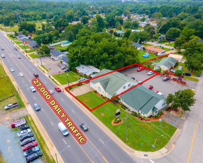
This Property Is For Sale
NEARBY LISTINGS FOR SALE OR LEASE
Property Detail
2216 Hope Mills Rd
Fayetteville, NC
H Mills Rd/Wingate To Camden
0416-00-5784
KOONTZ REV LO:PT 21 SE:01 PL:0025-0002
Officebuilding
Cumberland
X
North Carolina
3720041600J
21
2025
0.28 AC
2024
Southwest Fayetteville
001903
Fayetteville
3,014 SF
DEMOGRAPHICS near 2216 Hope Mills Rd
1 Mile
3 Mile
5 Mile
2024 Total Population
8,217
64,820
148,096
2029 Population
8,156
64,862
147,863
Pop Growth 2024-2029
(0.74%)
+ 0.06%
(0.16%)
Average Age
39
37
37
2024 Total Households
3,488
26,216
60,184
HH Growth 2024-2029
(0.66%)
+ 0.09%
(0.10%)
Median Household Inc
$52,547
$56,885
$62,593
Avg Household Size
2.30
2.40
2.40
2024 Avg HH Vehicles
2.00
2.00
2.00
Median Home Value
$139,705
$174,601
$208,822
Median Year Built
1976
1981
1985
Nearby Places
Map Layers
Map Styles
 Street
 Aerial
- Restaurants
- Banks
- Shops
- Fitness
- Groceries
PUBLIC TRANSPORTATION
COMMUTER RAIL
Fayetteville Amtrak Station (Palmetto - Amtrak, Silver Meteor - Amtrak)
DRIVE
WALK
Distance
Fayetteville Amtrak Station (Palmetto - Amtrak, Silver Meteor - Amtrak)
11 min
6.6 mi
AIRPORT
Fayetteville Regional/Grannis Field
DRIVE
WALK
Distance
Fayetteville Regional/Grannis Field
12 min
7.2 mi
Freight Ports
Port of Wilmington
DRIVE
WALK
Distance
Port of Wilmington
129 min
93.3 mi
Nearby Properties
Address
Land Use
TOTAL SIZE
Lot Size
Zoning
Address
Land Use
TOTAL SIZE
Lot Size
Zoning
182,282 SF
38.72 AC
OI
Address
Land Use
TOTAL SIZE
Lot Size
Zoning
2,064 SF
26.91 AC
R6CZ
Address
Land Use
TOTAL SIZE
Lot Size
Zoning
2,370 SF
15.66 AC
PND
Address
Land Use
TOTAL SIZE
Lot Size
Zoning
5,136 SF
19.84 AC
SF6
Address
Land Use
TOTAL SIZE
Lot Size
Zoning
54,316 SF
28.64 AC
CC
Address
Land Use
TOTAL SIZE
Lot Size
Zoning
2,314 SF
21.82 AC
MR5
Address
Land Use
TOTAL SIZE
Lot Size
Zoning
2,114 SF
20.70 AC
MR5
Address
Land Use
TOTAL SIZE
Lot Size
Zoning
1,064 SF
9.88 AC
R5C
Address
Land Use
TOTAL SIZE
Lot Size
Zoning
181,147 SF
24.02 AC
CCCZ
Address
Land Use
TOTAL SIZE
Lot Size
Zoning
66,637 SF
25.83 AC
RR
Address
Land Use
TOTAL SIZE
Lot Size
Zoning
135,996 SF
14.28 AC
CCCZ
Address
Land Use
TOTAL SIZE
Lot Size
Zoning
2,529 SF
5.95 AC
MR5
Address
Land Use
TOTAL SIZE
Lot Size
Zoning
6,670 SF
7.11 AC
CC
Address
Land Use
TOTAL SIZE
Lot Size
Zoning
1,289 SF
37.83 AC
MR5
Address
Land Use
TOTAL SIZE
Lot Size
Zoning
3,840 SF
17.54 AC
UK-UNKNOWN
Address
Land Use
TOTAL SIZE
Lot Size
Zoning
26,016 SF
30.11 AC
SF10
Address
Land Use
TOTAL SIZE
Lot Size
Zoning
780 SF
19.30 AC
SF10
Address
Land Use
TOTAL SIZE
Lot Size
Zoning
26,717 SF
89.19 AC
SF10
Address
Land Use
TOTAL SIZE
Lot Size
Zoning
3,411 SF
13.09 AC
MR5
Address
Land Use
TOTAL SIZE
Lot Size
Zoning
1,064 SF
15.55 AC
MR5
Address
Land Use
TOTAL SIZE
Lot Size
Zoning
120,262 SF
12.45 AC
CP
Address
Land Use
TOTAL SIZE
Lot Size
Zoning
4,549 SF
29.20 AC
MR5
Address
Land Use
TOTAL SIZE
Lot Size
Zoning
182,425 SF
23.13 AC
CP
Address
Land Use
TOTAL SIZE
Lot Size
Zoning
47,279 SF
19.56 AC
LC
Address
Land Use
TOTAL SIZE
Lot Size
Zoning
2,860 SF
16.90 AC
SF10
Address
Land Use
TOTAL SIZE
Lot Size
Zoning
1,823 SF
4.02 AC
R5A
Address
Land Use
TOTAL SIZE
Lot Size
Zoning
121,079 SF
15.39 AC
CP
Address
Land Use
TOTAL SIZE
Lot Size
Zoning
54,706 SF
27.30 AC
R10
Address
Land Use
TOTAL SIZE
Lot Size
Zoning
49.27 AC
MP-PLND IN
Address
Land Use
TOTAL SIZE
Lot Size
Zoning
2,126 SF
6.67 AC
MXDCU
The World's #1 Commercial Real Estate Marketplace
Connect with us
© 2025 CoStar Group
The information above has been obtained from sources believed reliable. While we do not doubt its accuracy we have not verified it and make no guarantee, warranty or representation about it. It is your responsibility to independently confirm its accuracy and completeness. Any projections, opinions, assumptions, or estimates used are for example only and do not represent the current or future performance of the property. The value of this transaction to you depends on tax and other factors which should be evaluated by your tax, financial, and legal advisors. You and your advisors should conduct a careful, independent investigation of the property to determine to your satisfaction the suitability of the property for your needs.