Property Record
2212 N 42Nd St, Quincy, IL 62305

NEARBY LISTINGS FOR SALE OR LEASE
Property Detail
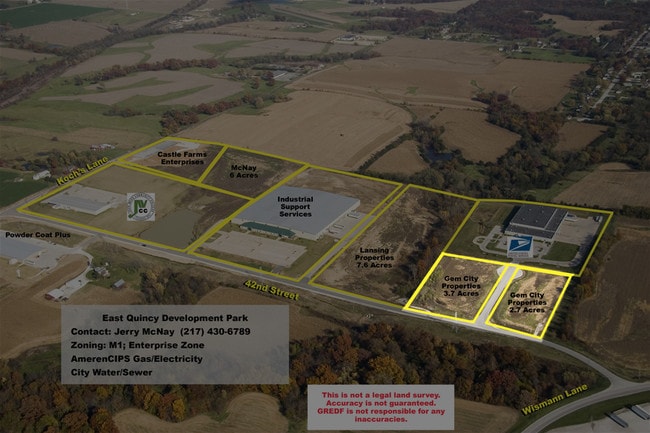
2212 N 42Nd St
Quincy, IL-MO
Mcnay Industrial Park Sub
19-0-0568-008-00
LOT 2 MCNAY INDUSTRIAL PARK SUB LOT 2
Commercialnec
Adams
X
Illinois
17001C0328D
2
2024
2.74 AC
2024
Effingham/Central Illinois Area
000100
Other Market Areas
DEMOGRAPHICS near 2212 N 42Nd St
1 Mile
3 Mile
5 Mile
2024 Total Population
585
23,534
49,116
2029 Population
572
23,225
48,627
Pop Growth 2024-2029
(2.22%)
(1.31%)
(1.00%)
Average Age
43
42
42
2024 Total Households
231
10,030
20,807
HH Growth 2024-2029
(2.16%)
(1.38%)
(1.09%)
Median Household Inc
$84,642
$63,648
$56,545
Avg Household Size
2.50
2.20
2.20
2024 Avg HH Vehicles
2.00
2.00
2.00
Median Home Value
$211,321
$155,380
$148,477
Median Year Built
1973
1966
1962
Nearby Places
Map Layers
Map Styles
 Street
 Aerial
- Restaurants
- Banks
- Shops
- Fitness
- Groceries
PUBLIC TRANSPORTATION
COMMUTER RAIL
Quincy Amtrak Station (Carl Sandburg - Amtrak, Illinois Zephyr - Amtrak)
DRIVE
WALK
Distance
Quincy Amtrak Station (Carl Sandburg - Amtrak, Illinois Zephyr - Amtrak)
3 min
1.2 mi
Freight Ports
Port Milwaukee
DRIVE
WALK
Distance
Port Milwaukee
401 min
349.6 mi
Nearby Properties
Address
Land Use
TOTAL SIZE
Lot Size
Zoning
Address
Land Use
TOTAL SIZE
Lot Size
Zoning
39.60 AC
Address
Land Use
TOTAL SIZE
Lot Size
Zoning
Address
Land Use
TOTAL SIZE
Lot Size
Zoning
19.52 AC
Address
Land Use
TOTAL SIZE
Lot Size
Zoning
21.30 AC
Address
Land Use
TOTAL SIZE
Lot Size
Zoning
19.49 AC
Address
Land Use
TOTAL SIZE
Lot Size
Zoning
1.65 AC
Address
Land Use
TOTAL SIZE
Lot Size
Zoning
9.67 AC
Address
Land Use
TOTAL SIZE
Lot Size
Zoning
21.03 AC
Address
Land Use
TOTAL SIZE
Lot Size
Zoning
30.48 AC
Address
Land Use
TOTAL SIZE
Lot Size
Zoning
11.17 AC
Address
Land Use
TOTAL SIZE
Lot Size
Zoning
41.26 AC
Address
Land Use
TOTAL SIZE
Lot Size
Zoning
7.35 AC
Address
Land Use
TOTAL SIZE
Lot Size
Zoning
8.74 AC
Address
Land Use
TOTAL SIZE
Lot Size
Zoning
11.79 AC
Address
Land Use
TOTAL SIZE
Lot Size
Zoning
12.87 AC
Address
Land Use
TOTAL SIZE
Lot Size
Zoning
20.17 AC
Address
Land Use
TOTAL SIZE
Lot Size
Zoning
9.67 AC
Address
Land Use
TOTAL SIZE
Lot Size
Zoning
3.60 AC
Address
Land Use
TOTAL SIZE
Lot Size
Zoning
7.51 AC
Address
Land Use
TOTAL SIZE
Lot Size
Zoning
6.16 AC
Address
Land Use
TOTAL SIZE
Lot Size
Zoning
7.04 AC
Address
Land Use
TOTAL SIZE
Lot Size
Zoning
Address
Land Use
TOTAL SIZE
Lot Size
Zoning
9.09 AC
Address
Land Use
TOTAL SIZE
Lot Size
Zoning
32.12 AC
Address
Land Use
TOTAL SIZE
Lot Size
Zoning
17.30 AC
Address
Land Use
TOTAL SIZE
Lot Size
Zoning
11.40 AC
Address
Land Use
TOTAL SIZE
Lot Size
Zoning
65.13 AC
Address
Land Use
TOTAL SIZE
Lot Size
Zoning
39.97 AC
Address
Land Use
TOTAL SIZE
Lot Size
Zoning
23.52 AC
Address
Land Use
TOTAL SIZE
Lot Size
Zoning
5.31 AC
The World's #1 Commercial Real Estate Marketplace
Connect with us
© 2025 CoStar Group
The information above has been obtained from sources believed reliable. While we do not doubt its accuracy we have not verified it and make no guarantee, warranty or representation about it. It is your responsibility to independently confirm its accuracy and completeness. Any projections, opinions, assumptions, or estimates used are for example only and do not represent the current or future performance of the property. The value of this transaction to you depends on tax and other factors which should be evaluated by your tax, financial, and legal advisors. You and your advisors should conduct a careful, independent investigation of the property to determine to your satisfaction the suitability of the property for your needs.