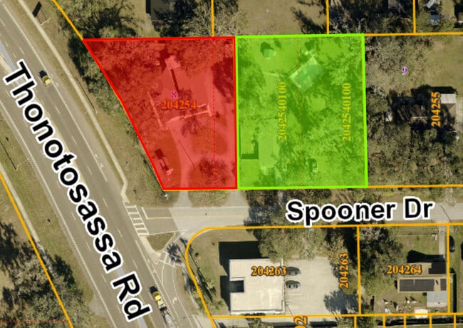
Property Record
2214 Thonotosassa Rd, Plant City, FL 33563

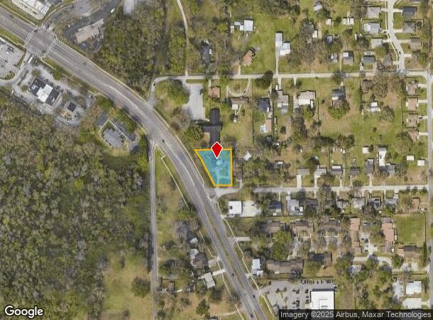
This Property Is For Sale
NEARBY LISTINGS FOR SALE OR LEASE
Property Detail
2214 Thonotosassa Rd
Tampa-St. Petersburg-Clearwater, FL
Small Farms
P-30-28-22-58K-000002-00008.0
SMALL FARMS N 180 FT OF LOTS 8 AND 9 BLOCK 2 LESS E 153 FT OF LOT 9...LESS W 150 FT OF E 303 FT OF N 189 FT OF LOT 9...LESS R/W FOR THONOTOSASSA RD BLOCK 2
Storebuilding
Hillsborough
X
Florida
12057C0269H
8
2024
0.51 AC
2024
Eastern Outlying
012701
Tampa/St Petersburg
4,944 SF
DEMOGRAPHICS near 2214 Thonotosassa Rd
1 Mile
3 Mile
5 Mile
2024 Total Population
6,245
42,959
71,581
2029 Population
6,805
46,913
78,209
Pop Growth 2024-2029
+ 8.97%
+ 9.20%
+ 9.26%
Average Age
37
39
39
2024 Total Households
2,267
15,567
24,790
HH Growth 2024-2029
+ 9.31%
+ 9.50%
+ 9.54%
Median Household Inc
$44,216
$54,259
$58,114
Avg Household Size
2.70
2.70
2.80
2024 Avg HH Vehicles
2.00
2.00
2.00
Median Home Value
$153,089
$210,423
$247,483
Median Year Built
1982
1984
1987
Nearby Places
- Restaurants
- Banks
- Shops
- Fitness
- Groceries
PUBLIC TRANSPORTATION
AIRPORT
Tampa International
DRIVE
WALK
Distance
Tampa International
37 min
28.6 mi
St Pete-Clearwater International
DRIVE
WALK
Distance
St Pete-Clearwater International
48 min
37.1 mi
Nearby Properties
Address
Land Use
TOTAL SIZE
Lot Size
Zoning
Address
Land Use
TOTAL SIZE
Lot Size
Zoning
519,942 SF
130.03 AC
I
Address
Land Use
TOTAL SIZE
Lot Size
Zoning
286,824 SF
43.15 AC
PD
Address
Land Use
TOTAL SIZE
Lot Size
Zoning
235,102 SF
7.73 AC
P
Address
Land Use
TOTAL SIZE
Lot Size
Zoning
243,294 SF
19.80 AC
CC
Address
Land Use
TOTAL SIZE
Lot Size
Zoning
400,224 SF
39.13 AC
I
Address
Land Use
TOTAL SIZE
Lot Size
Zoning
296,496 SF
77.52 AC
P
Address
Land Use
TOTAL SIZE
Lot Size
Zoning
496,217 SF
35.02 AC
I
Address
Land Use
TOTAL SIZE
Lot Size
Zoning
93,924 SF
3.96 AC
DC
Address
Land Use
TOTAL SIZE
Lot Size
Zoning
213,188 SF
16.10 AC
PD
Address
Land Use
TOTAL SIZE
Lot Size
Zoning
152,518 SF
43.50 AC
C-1A
Address
Land Use
TOTAL SIZE
Lot Size
Zoning
35,426 SF
39.92 AC
P
Address
Land Use
TOTAL SIZE
Lot Size
Zoning
145,222 SF
36.47 AC
PD
Address
Land Use
TOTAL SIZE
Lot Size
Zoning
192,911 SF
16.36 AC
PD
Address
Land Use
TOTAL SIZE
Lot Size
Zoning
177,038 SF
16.95 AC
PD
Address
Land Use
TOTAL SIZE
Lot Size
Zoning
247,608 SF
25.84 AC
PD
Address
Land Use
TOTAL SIZE
Lot Size
Zoning
154,237 SF
17.92 AC
C
Address
Land Use
TOTAL SIZE
Lot Size
Zoning
252,166 SF
22.88 AC
I
Address
Land Use
TOTAL SIZE
Lot Size
Zoning
122,234 SF
191.15 AC
I
Address
Land Use
TOTAL SIZE
Lot Size
Zoning
159,805 SF
78.29 AC
P
Address
Land Use
TOTAL SIZE
Lot Size
Zoning
139,392 SF
73.31 AC
RO
Address
Land Use
TOTAL SIZE
Lot Size
Zoning
127,470 SF
7.84 AC
R-20
Address
Land Use
TOTAL SIZE
Lot Size
Zoning
73,613 SF
57.94 AC
R-1A
Address
Land Use
TOTAL SIZE
Lot Size
Zoning
145,521 SF
19.83 AC
C
Address
Land Use
TOTAL SIZE
Lot Size
Zoning
125,744 SF
19.48 AC
I
Address
Land Use
TOTAL SIZE
Lot Size
Zoning
242,449 SF
19.97 AC
R-6
Address
Land Use
TOTAL SIZE
Lot Size
Zoning
109,293 SF
18.01 AC
R-12
Address
Land Use
TOTAL SIZE
Lot Size
Zoning
481,620 SF
23.85 AC
I
Address
Land Use
TOTAL SIZE
Lot Size
Zoning
66,199 SF
4.32 AC
P
Address
Land Use
TOTAL SIZE
Lot Size
Zoning
90,436 SF
6.11 AC
C-1
Address
Land Use
TOTAL SIZE
Lot Size
Zoning
40,530 SF
2.36 AC
DC
The World's #1 Commercial Real Estate Marketplace
Connect with us
© 2025 CoStar Group
The information above has been obtained from sources believed reliable. While we do not doubt its accuracy we have not verified it and make no guarantee, warranty or representation about it. It is your responsibility to independently confirm its accuracy and completeness. Any projections, opinions, assumptions, or estimates used are for example only and do not represent the current or future performance of the property. The value of this transaction to you depends on tax and other factors which should be evaluated by your tax, financial, and legal advisors. You and your advisors should conduct a careful, independent investigation of the property to determine to your satisfaction the suitability of the property for your needs.