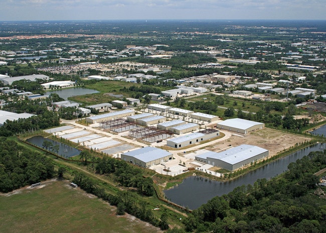
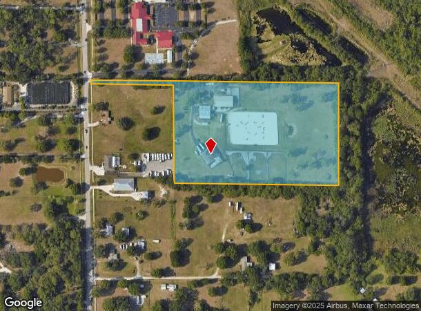
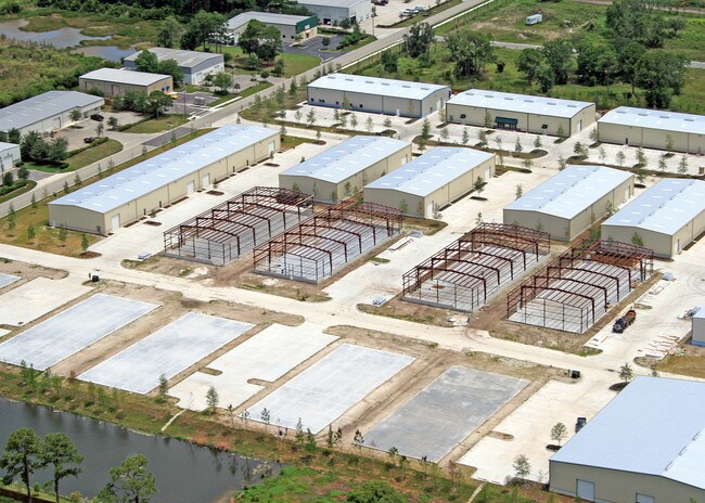
Property Record
2215 57Th St E, Bradenton, FL 34208
NEARBY LISTINGS FOR SALE OR LEASE
-
-
View all Bradenton listings for sale on LoopNet.com
Property Detail
2215 57Th St E
14417-1000-9
Not In Subdivision 0/0
Multifamilydwelling
FROM THE NW COR OF SW1/4 OF SE1/4 OF SEC 34-34-18, RUN S ALG 1/4 LN 334.45 FT TO A PT; TH S 88 DEG 38 MIN E, 462.18 FT FOR A POB; TH CONT S 88 DEG 38 MIN E, 836.92 FT TO THE E LN
X
Manatee
12081C0326F
Florida
2024
9.81 AC
2025
Manatee
002012
Tampa/St Petersburg
3,341 SF
North Port-Bradenton-Sarasota, FL
DEMOGRAPHICS near 2215 57Th St E
1 Mile
3 Mile
5 Mile
2024 Total Population
3,617
41,235
140,747
2029 Population
4,244
48,087
164,929
Pop Growth 2024-2029
+ 17.33%
+ 16.62%
+ 17.18%
Average Age
42
47
46
2024 Total Households
1,445
17,618
57,846
HH Growth 2024-2029
+ 16.40%
+ 15.71%
+ 16.37%
Median Household Inc
$55,759
$78,836
$71,777
Avg Household Size
2.50
2.30
2.30
2024 Avg HH Vehicles
2.00
2.00
2.00
Median Home Value
$305,970
$323,293
$320,325
Median Year Built
1993
1998
1998
Nearby Places
Map Layers
Map Styles
 Street
 Aerial
- Restaurants
- Banks
- Shops
- Fitness
- Groceries
PUBLIC TRANSPORTATION
AIRPORT
Sarasota/Bradenton International
DRIVE
WALK
Distance
Sarasota/Bradenton International
23 min
11.9 mi
Freight Ports
Port Manatee
DRIVE
WALK
Distance
Port Manatee
26 min
15.8 mi
Nearby Properties
Address
Land Use
TOTAL SIZE
Lot Size
Zoning
Address
Land Use
TOTAL SIZE
Lot Size
Zoning
881,490 SF
83.09 AC
BR_R-3
Address
Land Use
TOTAL SIZE
Lot Size
Zoning
513,465 SF
78.39 AC
PD-MU
Address
Land Use
TOTAL SIZE
Lot Size
Zoning
707,409 SF
27.98 AC
PD-MU
Address
Land Use
TOTAL SIZE
Lot Size
Zoning
319,679 SF
31.78 AC
BR_R-1
Address
Land Use
TOTAL SIZE
Lot Size
Zoning
241,504 SF
27.72 AC
A GENERAL
Address
Land Use
TOTAL SIZE
Lot Size
Zoning
311,669 SF
34.55 AC
BR_R-2
Address
Land Use
TOTAL SIZE
Lot Size
Zoning
293,332 SF
50.52 AC
A-1 SUBURB
Address
Land Use
TOTAL SIZE
Lot Size
Zoning
225,768 SF
18.47 AC
BR_R-1
Address
Land Use
TOTAL SIZE
Lot Size
Zoning
343,415 SF
31.02 AC
PD-C
Address
Land Use
TOTAL SIZE
Lot Size
Zoning
89,137 SF
11.61 AC
Address
Land Use
TOTAL SIZE
Lot Size
Zoning
348,901 SF
27 AC
BR_R-2
Address
Land Use
TOTAL SIZE
Lot Size
Zoning
187,000 SF
9.18 AC
Address
Land Use
TOTAL SIZE
Lot Size
Zoning
29,566 SF
1.17 AC
PD-PI
Address
Land Use
TOTAL SIZE
Lot Size
Zoning
160,163 SF
16.35 AC
PD-MU
Address
Land Use
TOTAL SIZE
Lot Size
Zoning
107,298 SF
12.91 AC
PD-MU
Address
Land Use
TOTAL SIZE
Lot Size
Zoning
10,389 SF
57.58 AC
PD-RV
Address
Land Use
TOTAL SIZE
Lot Size
Zoning
124,129 SF
23.29 AC
PDC
Address
Land Use
TOTAL SIZE
Lot Size
Zoning
310,215 SF
134.06 AC
A GENERAL
Address
Land Use
TOTAL SIZE
Lot Size
Zoning
220,706 SF
24.13 AC
PD-C, A-1
Address
Land Use
TOTAL SIZE
Lot Size
Zoning
234,818 SF
18.20 AC
BR_R-2
Address
Land Use
TOTAL SIZE
Lot Size
Zoning
201,982 SF
16.65 AC
BR_SCC
Address
Land Use
TOTAL SIZE
Lot Size
Zoning
10,094 SF
51.90 AC
PD-RV
Address
Land Use
TOTAL SIZE
Lot Size
Zoning
13,621 SF
61.72 AC
PD-RV,RSF-
Address
Land Use
TOTAL SIZE
Lot Size
Zoning
92,466 SF
18.80 AC
A-1 SUBURB
Address
Land Use
TOTAL SIZE
Lot Size
Zoning
88,713 SF
8.70 AC
PD-C
Address
Land Use
TOTAL SIZE
Lot Size
Zoning
89,912 SF
5.05 AC
Address
Land Use
TOTAL SIZE
Lot Size
Zoning
160,767 SF
15.63 AC
PD-C
Address
Land Use
TOTAL SIZE
Lot Size
Zoning
53,884 SF
2.33 AC
PD-C
Address
Land Use
TOTAL SIZE
Lot Size
Zoning
66,718 SF
6.56 AC
PD-R
Address
Land Use
TOTAL SIZE
Lot Size
Zoning
151,596 SF
29.79 AC
BR_PDP
The World's #1 Commercial Real Estate Marketplace
Connect with us
© 2026 CoStar Group
The information above has been obtained from sources believed reliable. While we do not doubt its accuracy we have not verified it and make no guarantee, warranty or representation about it. It is your responsibility to independently confirm its accuracy and completeness. Any projections, opinions, assumptions, or estimates used are for example only and do not represent the current or future performance of the property. The value of this transaction to you depends on tax and other factors which should be evaluated by your tax, financial, and legal advisors. You and your advisors should conduct a careful, independent investigation of the property to determine to your satisfaction the suitability of the property for your needs.