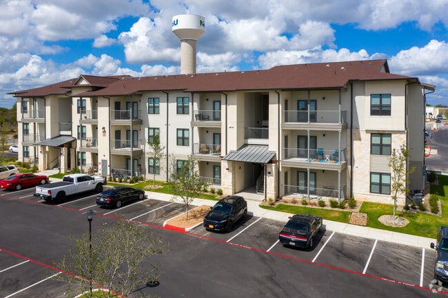
Property Record
2215 Independence Dr, New Braunfels, TX 78132


Property Detail
2215 Independence Dr
San Antonio-New Braunfels, TX
WESTPOINTE VILLAGE APARTMENTS, LOT 8R
56-0285-0130-00
Comal
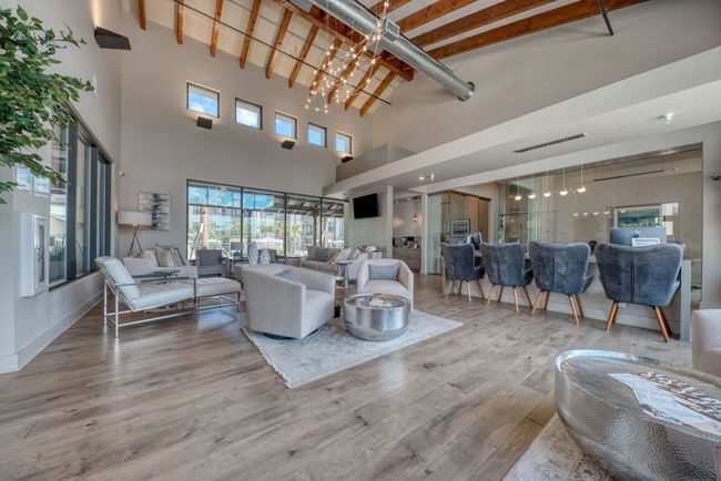
Apartment
Texas
B and X Area of moderate flood hazard, usually the area between the limits of the 100-year and 500-year floods.
8r
2024
11.38 AC
2025
South Comal
310803
San Antonio
215,244 SF
NEARBY LISTINGS FOR SALE OR LEASE
DEMOGRAPHICS near 2215 Independence Dr
1 mile
3 mile
5 mile
2025 Total Population
6,885
37,379
90,718
2030 Population
8,061
43,753
105,354
Pop Growth 2025-2030
+ 17.08%
+ 17.05%
+ 16.13%
Average Age
42
41
39
2025 Total Households
2,872
14,978
34,938
HH Growth 2025-2030
+ 17.06%
+ 17.11%
+ 16.43%
Median Household Inc
$105,679
$88,472
$91,961
Avg Household Size
2.40
2.40
2.50
2025 Avg HH Vehicles
2.00
2.00
2.00
Median Home Value
$514,228
$464,421
$383,430
Median Year Built
2010
1997
2003
Nearby Places
Map Layers
Map Styles
 Street
 Aerial
Layers
 Traffic
 Biking
Places
Listings with unknown addresses are not visible on the map
- Restaurants
- Banks
- Shops
- Fitness
- Groceries
PUBLIC TRANSPORTATION
AIRPORT
San Antonio International
Drive
Walk
Distance
San Antonio International
33 min
26.3 mi
Freight Ports
Calhoun Port
Drive
Walk
Distance
Calhoun Port
177 min
149.6 mi
Nearby Properties
Address
Land Use
TOTAL SIZE
Lot Size
Zoning
Address
Land Use
TOTAL SIZE
Lot Size
Zoning
350,595 SF
21.78 AC
Address
Land Use
TOTAL SIZE
Lot Size
Zoning
304,097 SF
14.98 AC
Address
Land Use
TOTAL SIZE
Lot Size
Zoning
433,083 SF
16.24 AC
Address
Land Use
TOTAL SIZE
Lot Size
Zoning
251,498 SF
8.63 AC
Address
Land Use
TOTAL SIZE
Lot Size
Zoning
1.80 AC
Address
Land Use
TOTAL SIZE
Lot Size
Zoning
325,518 SF
12.97 AC
Address
Land Use
TOTAL SIZE
Lot Size
Zoning
225,158 SF
52.63 AC
Address
Land Use
TOTAL SIZE
Lot Size
Zoning
170,266 SF
16.78 AC
Address
Land Use
TOTAL SIZE
Lot Size
Zoning
Address
Land Use
TOTAL SIZE
Lot Size
Zoning
229,773 SF
11.18 AC
Address
Land Use
TOTAL SIZE
Lot Size
Zoning
103,782 SF
105.82 AC
Address
Land Use
TOTAL SIZE
Lot Size
Zoning
102,856 SF
16.06 AC
Address
Land Use
TOTAL SIZE
Lot Size
Zoning
88,620 SF
10.11 AC
Address
Land Use
TOTAL SIZE
Lot Size
Zoning
397,600 SF
25.95 AC
Address
Land Use
TOTAL SIZE
Lot Size
Zoning
170,019 SF
4.46 AC
Address
Land Use
TOTAL SIZE
Lot Size
Zoning
105,976 SF
30.86 AC
Address
Land Use
TOTAL SIZE
Lot Size
Zoning
188,600 SF
4.61 AC
Address
Land Use
TOTAL SIZE
Lot Size
Zoning
132,319 SF
8.80 AC
Address
Land Use
TOTAL SIZE
Lot Size
Zoning
97,200 SF
12.87 AC
Address
Land Use
TOTAL SIZE
Lot Size
Zoning
105,729 SF
12.66 AC
Address
Land Use
TOTAL SIZE
Lot Size
Zoning
117,201 SF
4.72 AC
Address
Land Use
TOTAL SIZE
Lot Size
Zoning
61,079 SF
2.53 AC
Address
Land Use
TOTAL SIZE
Lot Size
Zoning
130,210 SF
13.57 AC
Address
Land Use
TOTAL SIZE
Lot Size
Zoning
127,491 SF
11 AC
Address
Land Use
TOTAL SIZE
Lot Size
Zoning
205,071 SF
23.66 AC
Address
Land Use
TOTAL SIZE
Lot Size
Zoning
93,699 SF
41.62 AC
Address
Land Use
TOTAL SIZE
Lot Size
Zoning
92,822 SF
4.94 AC
Address
Land Use
TOTAL SIZE
Lot Size
Zoning
122,247 SF
5.75 AC
Address
Land Use
TOTAL SIZE
Lot Size
Zoning
67,722 SF
6.88 AC
The World's #1 Commercial Real Estate Marketplace
Connect with us
© 2026 CoStar Group
The information above has been obtained from sources believed reliable. While we do not doubt its accuracy we have not verified it and make no guarantee, warranty or representation about it. It is your responsibility to independently confirm its accuracy and completeness. Any projections, opinions, assumptions, or estimates used are for example only and do not represent the current or future performance of the property. The value of this transaction to you depends on tax and other factors which should be evaluated by your tax, financial, and legal advisors. You and your advisors should conduct a careful, independent investigation of the property to determine to your satisfaction the suitability of the property for your needs.