Property Record
2215 Marlton Pike, Marlton, NJ 08053
NEARBY LISTINGS FOR SALE OR LEASE
Property Detail
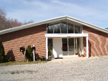
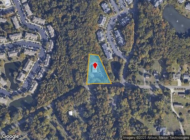
2215 Marlton Pike
13-00017-0000-00011-01
Burlington
Officebuilding
New Jersey
X
11.1
34005C0263F
1.24 AC
2024
South Burlington County
2025
Philadelphia
704009
Philadelphia-Camden-Wilmington, PA-NJ-DE-MD
2,352 SF
DEMOGRAPHICS near 2215 Marlton Pike
1 Mile
3 Mile
5 Mile
2024 Total Population
6,327
50,925
120,215
2029 Population
6,492
51,890
121,886
Pop Growth 2024-2029
+ 2.61%
+ 1.89%
+ 1.39%
Average Age
42
43
43
2024 Total Households
2,690
20,164
47,132
HH Growth 2024-2029
+ 2.60%
+ 1.98%
+ 1.38%
Median Household Inc
$104,249
$118,564
$122,414
Avg Household Size
2.30
2.50
2.50
2024 Avg HH Vehicles
2.00
2.00
2.00
Median Home Value
$340,295
$365,220
$357,471
Median Year Built
1999
1986
1984
Nearby Places
Map Layers
Map Styles
 Street
 Aerial
- Restaurants
- Banks
- Shops
- Fitness
- Groceries
PUBLIC TRANSPORTATION
COMMUTER RAIL
Lindenwold (NJT) (Atlantic City Line - NJ Transit Commuter Rail (NJ Transit))
DRIVE
WALK
Distance
Lindenwold (NJT) (Atlantic City Line - NJ Transit Commuter Rail (NJ Transit))
20 min
9.3 mi
AIRPORT
Philadelphia International
DRIVE
WALK
Distance
Philadelphia International
41 min
26.5 mi
Trenton Mercer
DRIVE
WALK
Distance
Trenton Mercer
56 min
36.4 mi
Atlantic City International
DRIVE
WALK
Distance
Atlantic City International
79 min
43.2 mi
Freight Ports
South Jersey Port
DRIVE
WALK
Distance
South Jersey Port
24 min
15.2 mi
Nearby Properties
Address
Land Use
TOTAL SIZE
Lot Size
Zoning
Address
Land Use
TOTAL SIZE
Lot Size
Zoning
1,896 SF
93.79 AC
LD
Address
Land Use
TOTAL SIZE
Lot Size
Zoning
50.60 AC
PPE
Address
Land Use
TOTAL SIZE
Lot Size
Zoning
53.35 AC
LD
Address
Land Use
TOTAL SIZE
Lot Size
Zoning
44.80 AC
C-1
Address
Land Use
TOTAL SIZE
Lot Size
Zoning
5 AC
C-1
Address
Land Use
TOTAL SIZE
Lot Size
Zoning
58.48 AC
MD
Address
Land Use
TOTAL SIZE
Lot Size
Zoning
52.30 AC
MD
Address
Land Use
TOTAL SIZE
Lot Size
Zoning
Address
Land Use
TOTAL SIZE
Lot Size
Zoning
2,600 SF
37.38 AC
AH-1
Address
Land Use
TOTAL SIZE
Lot Size
Zoning
9.38 AC
C-1
Address
Land Use
TOTAL SIZE
Lot Size
Zoning
42.80 AC
MF
Address
Land Use
TOTAL SIZE
Lot Size
Zoning
3 AC
GMN
Address
Land Use
TOTAL SIZE
Lot Size
Zoning
23.43 AC
INS
Address
Land Use
TOTAL SIZE
Lot Size
Zoning
31.88 AC
MD
Address
Land Use
TOTAL SIZE
Lot Size
Zoning
16.60 AC
Address
Land Use
TOTAL SIZE
Lot Size
Zoning
10.38 AC
C-1
Address
Land Use
TOTAL SIZE
Lot Size
Zoning
1,416 SF
16.88 AC
C-1
Address
Land Use
TOTAL SIZE
Lot Size
Zoning
5,484 SF
12.90 AC
C-1
Address
Land Use
TOTAL SIZE
Lot Size
Zoning
13,636 SF
23 AC
HC-1
Address
Land Use
TOTAL SIZE
Lot Size
Zoning
140.84 AC
MD
Address
Land Use
TOTAL SIZE
Lot Size
Zoning
10,000 SF
10.80 AC
RD-1
Address
Land Use
TOTAL SIZE
Lot Size
Zoning
34.74 AC
PPE/
Address
Land Use
TOTAL SIZE
Lot Size
Zoning
22.74 AC
HC-1
Address
Land Use
TOTAL SIZE
Lot Size
Zoning
26.16 AC
MF
Address
Land Use
TOTAL SIZE
Lot Size
Zoning
128.02 AC
PPE
Address
Land Use
TOTAL SIZE
Lot Size
Zoning
Address
Land Use
TOTAL SIZE
Lot Size
Zoning
11.54 AC
MD
Address
Land Use
TOTAL SIZE
Lot Size
Zoning
46.66 AC
AH3
Address
Land Use
TOTAL SIZE
Lot Size
Zoning
86.30 AC
PPE
Address
Land Use
TOTAL SIZE
Lot Size
Zoning
0.35 AC
MD
The World's #1 Commercial Real Estate Marketplace
Connect with us
© 2025 CoStar Group
The information above has been obtained from sources believed reliable. While we do not doubt its accuracy we have not verified it and make no guarantee, warranty or representation about it. It is your responsibility to independently confirm its accuracy and completeness. Any projections, opinions, assumptions, or estimates used are for example only and do not represent the current or future performance of the property. The value of this transaction to you depends on tax and other factors which should be evaluated by your tax, financial, and legal advisors. You and your advisors should conduct a careful, independent investigation of the property to determine to your satisfaction the suitability of the property for your needs.