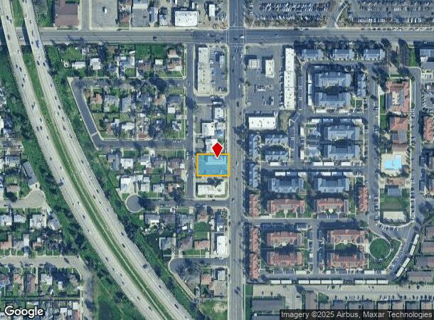
Property Record
2215 N Fresno St, Fresno, CA 93703

This Property Is For Sale
NEARBY LISTINGS FOR SALE OR LEASE
Property Detail
2215 N Fresno St
Fresno, CA
Clinton Park
446-045-04
2215 N FRESNO FR
Medicalbuilding
Fresno
X
California
06019C1570H
53,54
2025
0.30 AC
2025
Midtown
003401
Fresno
2,400 SF
DEMOGRAPHICS near 2215 N Fresno St
1 Mile
3 Mile
5 Mile
2024 Total Population
21,202
179,041
402,008
2029 Population
21,582
182,292
409,401
Pop Growth 2024-2029
+ 1.79%
+ 1.82%
+ 1.84%
Average Age
35
35
35
2024 Total Households
6,768
57,157
130,521
HH Growth 2024-2029
+ 1.76%
+ 1.84%
+ 1.88%
Median Household Inc
$33,977
$44,107
$47,800
Avg Household Size
3.00
3.00
2.90
2024 Avg HH Vehicles
2.00
2.00
2.00
Median Home Value
$209,722
$242,459
$259,373
Median Year Built
1955
1958
1968
Nearby Places
- Restaurants
- Banks
- Shops
- Fitness
- Groceries
PUBLIC TRANSPORTATION
COMMUTER RAIL
Fresno (San Joaquins - Amtrak)
DRIVE
WALK
Distance
Fresno (San Joaquins - Amtrak)
4 min
2.7 mi
AIRPORT
Fresno Yosemite International
DRIVE
WALK
Distance
Fresno Yosemite International
7 min
3.6 mi
Freight Ports
Port of Stockton
DRIVE
WALK
Distance
Port of Stockton
151 min
126.6 mi
Nearby Properties
Address
Land Use
TOTAL SIZE
Lot Size
Zoning
Address
Land Use
TOTAL SIZE
Lot Size
Zoning
574,093 SF
25.54 AC
C3
Address
Land Use
TOTAL SIZE
Lot Size
Zoning
534,993 SF
5.23 AC
CP
Address
Land Use
TOTAL SIZE
Lot Size
Zoning
0.01 AC
P
Address
Land Use
TOTAL SIZE
Lot Size
Zoning
288,597 SF
1.18 AC
C4
Address
Land Use
TOTAL SIZE
Lot Size
Zoning
184,130 SF
1.87 AC
PI
Address
Land Use
TOTAL SIZE
Lot Size
Zoning
471,760 SF
1.98 AC
CP
Address
Land Use
TOTAL SIZE
Lot Size
Zoning
213,874 SF
4.17 AC
SPLIT
Address
Land Use
TOTAL SIZE
Lot Size
Zoning
79,518 SF
2.03 AC
R4
Address
Land Use
TOTAL SIZE
Lot Size
Zoning
480,570 SF
2.98 AC
P
Address
Land Use
TOTAL SIZE
Lot Size
Zoning
90,500 SF
1.29 AC
CM
Address
Land Use
TOTAL SIZE
Lot Size
Zoning
110,456 SF
6.56 AC
RMX
Address
Land Use
TOTAL SIZE
Lot Size
Zoning
96,012 SF
1.33 AC
C4
Address
Land Use
TOTAL SIZE
Lot Size
Zoning
669,447 SF
0.01 AC
C3
Address
Land Use
TOTAL SIZE
Lot Size
Zoning
82,096 SF
0.26 AC
C4
Address
Land Use
TOTAL SIZE
Lot Size
Zoning
96,012 SF
0.60 AC
C4
Address
Land Use
TOTAL SIZE
Lot Size
Zoning
70,168 SF
4.97 AC
R3
Address
Land Use
TOTAL SIZE
Lot Size
Zoning
179,240 SF
12 AC
C3
Address
Land Use
TOTAL SIZE
Lot Size
Zoning
203,687 SF
10.63 AC
R3
Address
Land Use
TOTAL SIZE
Lot Size
Zoning
121,250 SF
9.51 AC
R3
Address
Land Use
TOTAL SIZE
Lot Size
Zoning
80,771 SF
7.47 AC
C2
Address
Land Use
TOTAL SIZE
Lot Size
Zoning
141,577 SF
12.76 AC
IL
Address
Land Use
TOTAL SIZE
Lot Size
Zoning
81,754 SF
5.75 AC
C3
Address
Land Use
TOTAL SIZE
Lot Size
Zoning
110,341 SF
5.45 AC
R3
Address
Land Use
TOTAL SIZE
Lot Size
Zoning
89,097 SF
0.63 AC
CC
Address
Land Use
TOTAL SIZE
Lot Size
Zoning
220,564 SF
12.83 AC
SPLIT
Address
Land Use
TOTAL SIZE
Lot Size
Zoning
191,136 SF
12.12 AC
R2
Address
Land Use
TOTAL SIZE
Lot Size
Zoning
92,096 SF
0.01 AC
C3
Address
Land Use
TOTAL SIZE
Lot Size
Zoning
91,517 SF
1.80 AC
SPLIT
Address
Land Use
TOTAL SIZE
Lot Size
Zoning
108,288 SF
7.12 AC
R2A
Address
Land Use
TOTAL SIZE
Lot Size
Zoning
108,017 SF
2.91 AC
CM
The World's #1 Commercial Real Estate Marketplace
Connect with us
© 2025 CoStar Group
The information above has been obtained from sources believed reliable. While we do not doubt its accuracy we have not verified it and make no guarantee, warranty or representation about it. It is your responsibility to independently confirm its accuracy and completeness. Any projections, opinions, assumptions, or estimates used are for example only and do not represent the current or future performance of the property. The value of this transaction to you depends on tax and other factors which should be evaluated by your tax, financial, and legal advisors. You and your advisors should conduct a careful, independent investigation of the property to determine to your satisfaction the suitability of the property for your needs.