Property Record
2216 Macdade Blvd, Holmes, PA 19043
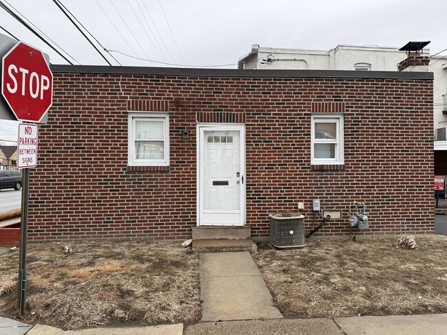

Property Detail
2216 Macdade Blvd
38-04-01481-00
1 STY DOCS OFC 27.57 X 31.75 X 31 X 24
Officebuilding
DELAWARE
B and X Area of moderate flood hazard, usually the area between the limits of the 100-year and 500-year floods.
Pennsylvania
2024
0.16 AC
2025
Delaware County
404004
Philadelphia
672 SF
Philadelphia-Camden-Wilmington, PA-NJ-DE-MD
NEARBY LISTINGS FOR SALE OR LEASE
DEMOGRAPHICS near 2216 Macdade Blvd
1 mile
3 mile
5 mile
2025 Total Population
26,482
153,687
378,008
2030 Population
26,750
155,387
381,414
Pop Growth 2025-2030
+ 1.01%
+ 1.11%
+ 0.90%
Average Age
41
40
40
2025 Total Households
10,611
59,109
143,730
HH Growth 2025-2030
+ 1.11%
+ 1.18%
+ 0.95%
Median Household Inc
$77,157
$77,052
$69,905
Avg Household Size
2.50
2.50
2.50
2025 Avg HH Vehicles
2.00
2.00
2.00
Median Home Value
$256,033
$256,290
$248,852
Median Year Built
1954
1954
1952
Nearby Places
Map Layers
Map Styles
 Street
 Aerial
Layers
 Traffic
 Biking
Places
Listings with unknown addresses are not visible on the map
- Restaurants
- Banks
- Shops
- Fitness
- Groceries
PUBLIC TRANSPORTATION
TRANSIT/SUBWAY
Norwood (R2 - Southeastern Pennsylvania Transportation Authority Regional Rail (SEPTA Regional Rail))
Drive
Walk
Distance
Norwood (R2 - Southeastern Pennsylvania Transportation Authority Regional Rail (SEPTA Regional Rail))
2 min
13 min
0.7 mi
COMMUTER RAIL
Norwood (R2 - Southeastern Pennsylvania Transportation Authority Regional Rail (SEPTA Regional Rail))
Drive
Walk
Distance
Norwood (R2 - Southeastern Pennsylvania Transportation Authority Regional Rail (SEPTA Regional Rail))
2 min
13 min
0.7 mi
Prospect Park (R2 - Southeastern Pennsylvania Transportation Authority Regional Rail (SEPTA Regional Rail))
Drive
Walk
Distance
Prospect Park (R2 - Southeastern Pennsylvania Transportation Authority Regional Rail (SEPTA Regional Rail))
3 min
19 min
1.0 mi
AIRPORT
Philadelphia International
Drive
Walk
Distance
Philadelphia International
13 min
5.8 mi
Trenton Mercer
Drive
Walk
Distance
Trenton Mercer
70 min
47.6 mi
Freight Ports
Broadway Terminal - Pier 5
Drive
Walk
Distance
Broadway Terminal - Pier 5
28 min
16.7 mi
SALE & LEASE HISTORY
LISTING DATE
SALE/LEASE

Aug 31, 2025
For Lease
Apr 17, 2025
For Sale
Nearby Properties
Address
Land Use
TOTAL SIZE
Lot Size
Zoning
Address
Land Use
TOTAL SIZE
Lot Size
Zoning
762,100 SF
Address
Land Use
TOTAL SIZE
Lot Size
Zoning
6,637 SF
198.92 AC
Address
Land Use
TOTAL SIZE
Lot Size
Zoning
175,978 SF
15.95 AC
Address
Land Use
TOTAL SIZE
Lot Size
Zoning
161,141 SF
170.40 AC
Address
Land Use
TOTAL SIZE
Lot Size
Zoning
164,182 SF
Address
Land Use
TOTAL SIZE
Lot Size
Zoning
112,896 SF
95 AC
Address
Land Use
TOTAL SIZE
Lot Size
Zoning
975.62 AC
Address
Land Use
TOTAL SIZE
Lot Size
Zoning
702,532 SF
11 AC
Address
Land Use
TOTAL SIZE
Lot Size
Zoning
6,040 SF
16.45 AC
Address
Land Use
TOTAL SIZE
Lot Size
Zoning
800,029 SF
112.10 AC
Address
Land Use
TOTAL SIZE
Lot Size
Zoning
156,079 SF
13.44 AC
Address
Land Use
TOTAL SIZE
Lot Size
Zoning
241,578 SF
14 AC
Address
Land Use
TOTAL SIZE
Lot Size
Zoning
136,972 SF
27 AC
Address
Land Use
TOTAL SIZE
Lot Size
Zoning
312,988 SF
24 AC
Address
Land Use
TOTAL SIZE
Lot Size
Zoning
255,316 SF
6 AC
Address
Land Use
TOTAL SIZE
Lot Size
Zoning
61,860 SF
6.29 AC
Address
Land Use
TOTAL SIZE
Lot Size
Zoning
2,608 SF
198.92 AC
Address
Land Use
TOTAL SIZE
Lot Size
Zoning
2,562 SF
198.92 AC
Address
Land Use
TOTAL SIZE
Lot Size
Zoning
12,100 SF
7 AC
Address
Land Use
TOTAL SIZE
Lot Size
Zoning
64,995 SF
132 AC
Address
Land Use
TOTAL SIZE
Lot Size
Zoning
86.10 AC
Address
Land Use
TOTAL SIZE
Lot Size
Zoning
40,572 SF
6.52 AC
Address
Land Use
TOTAL SIZE
Lot Size
Zoning
702,532 SF
Address
Land Use
TOTAL SIZE
Lot Size
Zoning
68,096 SF
7.78 AC
Address
Land Use
TOTAL SIZE
Lot Size
Zoning
282,520 SF
24.44 AC
Address
Land Use
TOTAL SIZE
Lot Size
Zoning
160,959 SF
7.97 AC
RM2
Address
Land Use
TOTAL SIZE
Lot Size
Zoning
107,530 SF
Address
Land Use
TOTAL SIZE
Lot Size
Zoning
187,056 SF
16 AC
Address
Land Use
TOTAL SIZE
Lot Size
Zoning
164,834 SF
13 AC
Address
Land Use
TOTAL SIZE
Lot Size
Zoning
343,204 SF
11.86 AC
The World's #1 Commercial Real Estate Marketplace
Connect with us
© 2026 CoStar Group
The information above has been obtained from sources believed reliable. While we do not doubt its accuracy we have not verified it and make no guarantee, warranty or representation about it. It is your responsibility to independently confirm its accuracy and completeness. Any projections, opinions, assumptions, or estimates used are for example only and do not represent the current or future performance of the property. The value of this transaction to you depends on tax and other factors which should be evaluated by your tax, financial, and legal advisors. You and your advisors should conduct a careful, independent investigation of the property to determine to your satisfaction the suitability of the property for your needs.