Property Record
2219 Lampton St, Muskogee, OK 74403

Property Detail
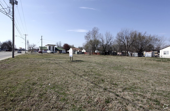
2219 Lampton St
Muskogee, OK
BONITO LOTS 19 & 20 BLOCK 6
6464
MUSKOGEE
Residentialacreage
Oklahoma
B and X Area of moderate flood hazard, usually the area between the limits of the 100-year and 500-year floods.
19,20
2025
0.16 AC
2025
Muskogee County
000902
Tulsa
NEARBY LISTINGS FOR SALE OR LEASE
DEMOGRAPHICS near 2219 Lampton St
1 mile
3 mile
5 mile
2025 Total Population
7,276
28,792
40,087
2030 Population
7,338
29,300
40,705
Pop Growth 2025-2030
+ 0.85%
+ 1.76%
+ 1.54%
Average Age
38
39
39
2025 Total Households
2,835
11,610
16,257
HH Growth 2025-2030
+ 0.81%
+ 1.83%
+ 1.60%
Median Household Inc
$52,580
$51,128
$51,214
Avg Household Size
2.40
2.30
2.30
2025 Avg HH Vehicles
2.00
2.00
2.00
Median Home Value
$90,736
$130,149
$142,491
Median Year Built
1956
1970
1971
Nearby Places
Map Layers
Map Styles
 Street
 Aerial
Transit
 Traffic
 Biking
Places
Listings with unknown addresses are not visible on the map
- Restaurants
- Banks
- Shops
- Fitness
- Groceries
SALE & LEASE HISTORY
LISTING DATE
SALE/LEASE

Jun 15, 2020
For Sale
Nearby Properties
Address
Land Use
TOTAL SIZE
Lot Size
Zoning
Address
Land Use
TOTAL SIZE
Lot Size
Zoning
50,548 SF
43.28 AC
Address
Land Use
TOTAL SIZE
Lot Size
Zoning
224,448 SF
30.08 AC
Address
Land Use
TOTAL SIZE
Lot Size
Zoning
14,016 SF
81.11 AC
Address
Land Use
TOTAL SIZE
Lot Size
Zoning
69,776 SF
20.13 AC
Address
Land Use
TOTAL SIZE
Lot Size
Zoning
71,364 SF
3.48 AC
F
Address
Land Use
TOTAL SIZE
Lot Size
Zoning
428,400 SF
385.75 AC
B
Address
Land Use
TOTAL SIZE
Lot Size
Zoning
19,548 SF
3.77 AC
B
Address
Land Use
TOTAL SIZE
Lot Size
Zoning
43,002 SF
1.09 AC
MI
Address
Land Use
TOTAL SIZE
Lot Size
Zoning
17,764 SF
5.40 AC
Address
Land Use
TOTAL SIZE
Lot Size
Zoning
41,924 SF
1.51 AC
MI
Address
Land Use
TOTAL SIZE
Lot Size
Zoning
11,474 SF
5.02 AC
G
Address
Land Use
TOTAL SIZE
Lot Size
Zoning
432 SF
5.21 AC
MI
Address
Land Use
TOTAL SIZE
Lot Size
Zoning
16,740 SF
3.62 AC
B
Address
Land Use
TOTAL SIZE
Lot Size
Zoning
5,984 SF
34.70 AC
Address
Land Use
TOTAL SIZE
Lot Size
Zoning
6,720 SF
20 AC
D
Address
Land Use
TOTAL SIZE
Lot Size
Zoning
21,332 SF
5.51 AC
Address
Land Use
TOTAL SIZE
Lot Size
Zoning
84,918 SF
1.21 AC
D
Address
Land Use
TOTAL SIZE
Lot Size
Zoning
9,000 SF
11.77 AC
Address
Land Use
TOTAL SIZE
Lot Size
Zoning
5,250 SF
5.40 AC
Address
Land Use
TOTAL SIZE
Lot Size
Zoning
34,070 SF
2.33 AC
PP
Address
Land Use
TOTAL SIZE
Lot Size
Zoning
11,071 SF
1.86 AC
Address
Land Use
TOTAL SIZE
Lot Size
Zoning
6,000 SF
1.39 AC
Address
Land Use
TOTAL SIZE
Lot Size
Zoning
4,812 SF
1.46 AC
E1
Address
Land Use
TOTAL SIZE
Lot Size
Zoning
25,200 SF
12.06 AC
Address
Land Use
TOTAL SIZE
Lot Size
Zoning
37,260 SF
1.93 AC
Address
Land Use
TOTAL SIZE
Lot Size
Zoning
8,244 SF
1.53 AC
E
Address
Land Use
TOTAL SIZE
Lot Size
Zoning
9,600 SF
64.75 AC
Address
Land Use
TOTAL SIZE
Lot Size
Zoning
14,880 SF
17.11 AC
Address
Land Use
TOTAL SIZE
Lot Size
Zoning
39,259 SF
1.54 AC
E
Address
Land Use
TOTAL SIZE
Lot Size
Zoning
30,594 SF
0.85 AC
E1
The World's #1 Commercial Real Estate Marketplace
Connect with us
© 2026 CoStar Group
The information above has been obtained from sources believed reliable. While we do not doubt its accuracy we have not verified it and make no guarantee, warranty or representation about it. It is your responsibility to independently confirm its accuracy and completeness. Any projections, opinions, assumptions, or estimates used are for example only and do not represent the current or future performance of the property. The value of this transaction to you depends on tax and other factors which should be evaluated by your tax, financial, and legal advisors. You and your advisors should conduct a careful, independent investigation of the property to determine to your satisfaction the suitability of the property for your needs.