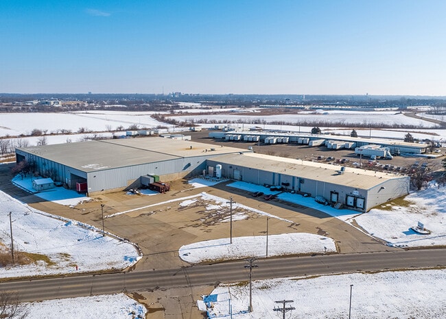
Property Record
2219 W College Ave, Normal, IL 61761


Save to a Folder
{{folder.Name}}
{{folder.ListingIds.length}} Properties
{{folder.ListingIds.length}} Property
Create a New Folder
Property Detail
2219 W College Ave
14-30-376-017
LOT 1 GALLOWAY RESUB OF NU-AIR CORP SUB
Commercialnec
McLean
M-2
Illinois
C and X Area of minimal flood hazard, usually depicted on FIRMs as above the 500-year flood level.
1
2022
7 AC
2024
Bloomington/Normal
000302
Other Market Areas
97,000 SF
Bloomington, IL
NEARBY LISTINGS FOR SALE OR LEASE
DEMOGRAPHICS near 2219 W College Ave
1 mile
3 mile
5 mile
2025 Total Population
1,073
44,797
98,021
2030 Population
1,061
45,136
98,491
Pop Growth 2025-2030
(1.12%)
+ 0.76%
+ 0.48%
Average Age
37
33
37
2025 Total Households
452
16,282
40,692
HH Growth 2025-2030
(1.33%)
+ 0.80%
+ 0.48%
Median Household Inc
$40,577
$47,839
$60,224
Avg Household Size
2.30
2.20
2.10
2025 Avg HH Vehicles
1.00
2.00
2.00
Median Home Value
$186,696
$160,014
$180,824
Median Year Built
1985
1975
1975
Nearby Places
Map Layers
Map Styles
 Street
 Aerial
Layers
 Traffic
 Biking
Places
Listings with unknown addresses are not visible on the map
- Restaurants
- Banks
- Shops
- Fitness
- Groceries
PUBLIC TRANSPORTATION
AIRPORT
Central Il Regional/Bloomington-Normal
Drive
Walk
Distance
Central Il Regional/Bloomington-Normal
20 min
8.4 mi
General Downing - Peoria International
Drive
Walk
Distance
General Downing - Peoria International
50 min
41.1 mi
SALE & LEASE HISTORY
LISTING DATE
SALE/LEASE

Sep 24, 2016
For Sale
Sep 24, 2016
For Sale
May 23, 2018
For Sale
Feb 04, 2021
For Sale
Apr 01, 2025
For Sale
Apr 01, 2025
For Lease
Nearby Properties
Address
Land Use
TOTAL SIZE
Lot Size
Zoning
Address
Land Use
TOTAL SIZE
Lot Size
Zoning
417.42 AC
Address
Land Use
TOTAL SIZE
Lot Size
Zoning
154,502 SF
1.25 AC
Address
Land Use
TOTAL SIZE
Lot Size
Zoning
493,944 SF
2.95 AC
R-3A
Address
Land Use
TOTAL SIZE
Lot Size
Zoning
48,629 SF
39 AC
Address
Land Use
TOTAL SIZE
Lot Size
Zoning
127,569 SF
1.54 AC
Address
Land Use
TOTAL SIZE
Lot Size
Zoning
158,508 SF
3.13 AC
R1C
Address
Land Use
TOTAL SIZE
Lot Size
Zoning
126,418 SF
1.06 AC
Address
Land Use
TOTAL SIZE
Lot Size
Zoning
432,093 SF
15 AC
Address
Land Use
TOTAL SIZE
Lot Size
Zoning
10.13 AC
R2
Address
Land Use
TOTAL SIZE
Lot Size
Zoning
422,234 SF
23.17 AC
Address
Land Use
TOTAL SIZE
Lot Size
Zoning
309,750 SF
9.85 AC
R-3A
Address
Land Use
TOTAL SIZE
Lot Size
Zoning
351,360 SF
8.40 AC
R-3A
Address
Land Use
TOTAL SIZE
Lot Size
Zoning
191,880 SF
3 AC
B-1
Address
Land Use
TOTAL SIZE
Lot Size
Zoning
62,551 SF
0.42 AC
B-2
Address
Land Use
TOTAL SIZE
Lot Size
Zoning
127,720 SF
1.68 AC
R-1C
Address
Land Use
TOTAL SIZE
Lot Size
Zoning
84,278 SF
0.36 AC
B-2
Address
Land Use
TOTAL SIZE
Lot Size
Zoning
51,320 SF
0.70 AC
B-1
Address
Land Use
TOTAL SIZE
Lot Size
Zoning
118,176 SF
2.30 AC
Address
Land Use
TOTAL SIZE
Lot Size
Zoning
34,720 SF
6.14 AC
R3A
Address
Land Use
TOTAL SIZE
Lot Size
Zoning
51,320 SF
0.50 AC
B-1
Address
Land Use
TOTAL SIZE
Lot Size
Zoning
126,428 SF
3.79 AC
Address
Land Use
TOTAL SIZE
Lot Size
Zoning
348,318 SF
7 AC
R-3A
Address
Land Use
TOTAL SIZE
Lot Size
Zoning
196,500 SF
5.07 AC
Address
Land Use
TOTAL SIZE
Lot Size
Zoning
36,784 SF
0.62 AC
B-1
Address
Land Use
TOTAL SIZE
Lot Size
Zoning
55,952 SF
0.34 AC
R3A
Address
Land Use
TOTAL SIZE
Lot Size
Zoning
28,055 SF
0.80 AC
B-2
Address
Land Use
TOTAL SIZE
Lot Size
Zoning
335,377 SF
9.78 AC
The World's #1 Commercial Real Estate Marketplace
Connect with us
© 2026 CoStar Group
The information above has been obtained from sources believed reliable. While we do not doubt its accuracy we have not verified it and make no guarantee, warranty or representation about it. It is your responsibility to independently confirm its accuracy and completeness. Any projections, opinions, assumptions, or estimates used are for example only and do not represent the current or future performance of the property. The value of this transaction to you depends on tax and other factors which should be evaluated by your tax, financial, and legal advisors. You and your advisors should conduct a careful, independent investigation of the property to determine to your satisfaction the suitability of the property for your needs.