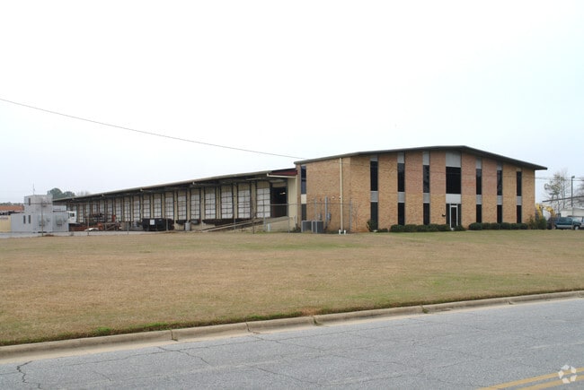
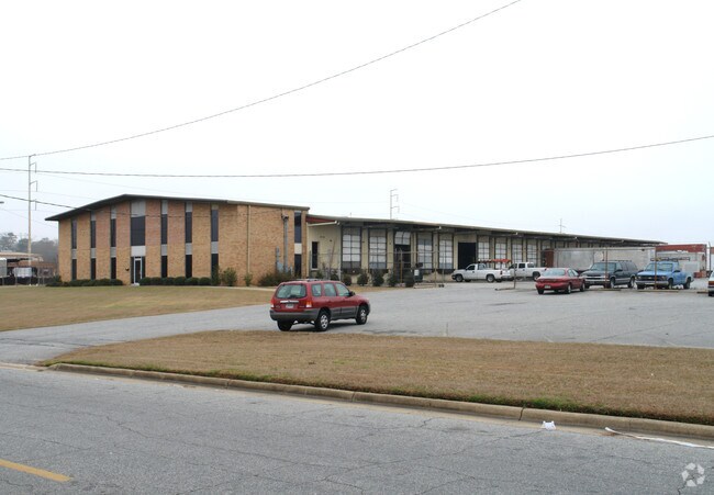
Property Record
222 22Nd Ave, Columbus, GA 31901

Property Detail
222 22Nd Ave
Columbus, GA-AL
LOT 1 REP OF PT OF TR 1 & 5 JAMES BLANCHARD IND PARK
022-003-003
Muscogee
Commercialnec
Georgia
C and X Area of minimal flood hazard, usually depicted on FIRMs as above the 500-year flood level.
1
2025
3.84 AC
2025
Greater Columbus
002700
Columbus GA
19,219 SF
NEARBY LISTINGS FOR SALE OR LEASE
DEMOGRAPHICS near 222 22Nd Ave
1 mile
3 mile
5 mile
2025 Total Population
5,956
59,824
136,680
2030 Population
5,940
59,543
135,736
Pop Growth 2025-2030
(0.27%)
(0.47%)
(0.69%)
Average Age
35
39
37
2025 Total Households
2,360
25,986
55,295
HH Growth 2025-2030
0.00%
(0.18%)
(0.73%)
Median Household Inc
$30,241
$33,724
$40,455
Avg Household Size
2.40
2.20
2.40
2025 Avg HH Vehicles
1.00
1.00
1.00
Median Home Value
$85,666
$134,421
$144,260
Median Year Built
1969
1966
1970
Nearby Places
Map Layers
Map Styles
 Street
 Aerial
Transit
 Traffic
 Biking
Places
Listings with unknown addresses are not visible on the map
- Restaurants
- Banks
- Shops
- Fitness
- Groceries
PUBLIC TRANSPORTATION
AIRPORT
Columbus
Drive
Walk
Distance
Columbus
15 min
8.5 mi
Nearby Properties
Address
Land Use
TOTAL SIZE
Lot Size
Zoning
Address
Land Use
TOTAL SIZE
Lot Size
Zoning
68,000 SF
11.21 AC
Address
Land Use
TOTAL SIZE
Lot Size
Zoning
32,750 SF
4.01 AC
Address
Land Use
TOTAL SIZE
Lot Size
Zoning
2.48 AC
Address
Land Use
TOTAL SIZE
Lot Size
Zoning
43,888 SF
2 AC
Address
Land Use
TOTAL SIZE
Lot Size
Zoning
65,875 SF
2.37 AC
Address
Land Use
TOTAL SIZE
Lot Size
Zoning
63,220 SF
3.49 AC
Address
Land Use
TOTAL SIZE
Lot Size
Zoning
97,648 SF
17.40 AC
Address
Land Use
TOTAL SIZE
Lot Size
Zoning
5,592 SF
13.41 AC
Address
Land Use
TOTAL SIZE
Lot Size
Zoning
56,095 SF
25.91 AC
Address
Land Use
TOTAL SIZE
Lot Size
Zoning
27,621 SF
6.33 AC
Address
Land Use
TOTAL SIZE
Lot Size
Zoning
2.31 AC
Address
Land Use
TOTAL SIZE
Lot Size
Zoning
32,238 SF
7.21 AC
Address
Land Use
TOTAL SIZE
Lot Size
Zoning
10,705 SF
0.64 AC
Address
Land Use
TOTAL SIZE
Lot Size
Zoning
31,847 SF
1.21 AC
Address
Land Use
TOTAL SIZE
Lot Size
Zoning
4,334 SF
13.29 AC
Address
Land Use
TOTAL SIZE
Lot Size
Zoning
133,276 SF
36.76 AC
Address
Land Use
TOTAL SIZE
Lot Size
Zoning
247,570 SF
28.07 AC
Address
Land Use
TOTAL SIZE
Lot Size
Zoning
1.21 AC
Address
Land Use
TOTAL SIZE
Lot Size
Zoning
34,866 SF
2.34 AC
Address
Land Use
TOTAL SIZE
Lot Size
Zoning
18,050 SF
1.17 AC
Address
Land Use
TOTAL SIZE
Lot Size
Zoning
29,640 SF
1.11 AC
Address
Land Use
TOTAL SIZE
Lot Size
Zoning
83,295 SF
17.87 AC
Address
Land Use
TOTAL SIZE
Lot Size
Zoning
78,948 SF
6 AC
Address
Land Use
TOTAL SIZE
Lot Size
Zoning
72,200 SF
5.52 AC
Address
Land Use
TOTAL SIZE
Lot Size
Zoning
56,775 SF
4.26 AC
Address
Land Use
TOTAL SIZE
Lot Size
Zoning
41,084 SF
5.58 AC
Address
Land Use
TOTAL SIZE
Lot Size
Zoning
8,888 SF
10 AC
O
Address
Land Use
TOTAL SIZE
Lot Size
Zoning
5,686 SF
17.64 AC
Address
Land Use
TOTAL SIZE
Lot Size
Zoning
48,100 SF
9 AC
Address
Land Use
TOTAL SIZE
Lot Size
Zoning
5,508 SF
61.13 AC
The World's #1 Commercial Real Estate Marketplace
Connect with us
© 2026 CoStar Group
The information above has been obtained from sources believed reliable. While we do not doubt its accuracy we have not verified it and make no guarantee, warranty or representation about it. It is your responsibility to independently confirm its accuracy and completeness. Any projections, opinions, assumptions, or estimates used are for example only and do not represent the current or future performance of the property. The value of this transaction to you depends on tax and other factors which should be evaluated by your tax, financial, and legal advisors. You and your advisors should conduct a careful, independent investigation of the property to determine to your satisfaction the suitability of the property for your needs.