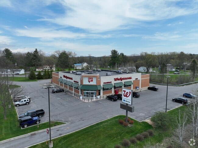
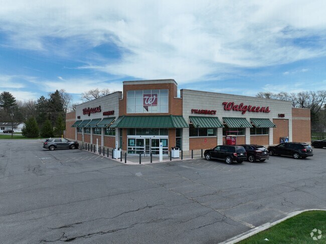
Property Record
222 5Th Ave Ext, Gloversville, NY 12078

NEARBY LISTINGS FOR SALE OR LEASE
Property Detail
222 5Th Ave Ext
Gloversville, NY
Fulton
172800-134-000-0003-026-000-0000
New York
Storesoffices
26.000
2025
3.80 AC
2024
Fulton County
970601
Albany/Schenectady/Troy
14,820 SF
DEMOGRAPHICS near 222 5Th Ave Ext
1 Mile
3 Mile
5 Mile
2024 Total Population
6,170
17,871
30,412
2029 Population
5,999
17,352
29,602
Pop Growth 2024-2029
(2.77%)
(2.90%)
(2.66%)
Average Age
42
42
42
2024 Total Households
2,650
7,532
12,874
HH Growth 2024-2029
(2.75%)
(2.89%)
(2.65%)
Median Household Inc
$53,957
$46,922
$52,263
Avg Household Size
2.20
2.20
2.20
2024 Avg HH Vehicles
2.00
2.00
2.00
Median Home Value
$94,860
$97,366
$124,014
Median Year Built
1947
1948
1948
Nearby Places
Map Layers
Map Styles
 Street
 Aerial
- Restaurants
- Banks
- Shops
- Fitness
- Groceries
SALE & LEASE HISTORY
LISTING DATE
SALE/LEASE

Jan 17, 2022
For Sale
Nearby Properties
Address
Land Use
TOTAL SIZE
Lot Size
Zoning
Address
Land Use
TOTAL SIZE
Lot Size
Zoning
155,394 SF
83.80 AC
R2
Address
Land Use
TOTAL SIZE
Lot Size
Zoning
154,349 SF
10.60 AC
R1
Address
Land Use
TOTAL SIZE
Lot Size
Zoning
65,000 SF
14.35 AC
01 - NOT Z
Address
Land Use
TOTAL SIZE
Lot Size
Zoning
151,246 SF
31.20 AC
M
Address
Land Use
TOTAL SIZE
Lot Size
Zoning
Address
Land Use
TOTAL SIZE
Lot Size
Zoning
Address
Land Use
TOTAL SIZE
Lot Size
Zoning
20,030 SF
3.60 AC
C
Address
Land Use
TOTAL SIZE
Lot Size
Zoning
120,454 SF
14.30 AC
06 - INDUS
Address
Land Use
TOTAL SIZE
Lot Size
Zoning
36,450 SF
4.70 AC
R1
Address
Land Use
TOTAL SIZE
Lot Size
Zoning
36,755 SF
1.70 AC
RC
Address
Land Use
TOTAL SIZE
Lot Size
Zoning
Address
Land Use
TOTAL SIZE
Lot Size
Zoning
Address
Land Use
TOTAL SIZE
Lot Size
Zoning
2.30 AC
M1
Address
Land Use
TOTAL SIZE
Lot Size
Zoning
135,278 SF
13.70 AC
C1
Address
Land Use
TOTAL SIZE
Lot Size
Zoning
9,074 SF
30.80 AC
C
Address
Land Use
TOTAL SIZE
Lot Size
Zoning
44,128 SF
5 AC
C1
Address
Land Use
TOTAL SIZE
Lot Size
Zoning
Address
Land Use
TOTAL SIZE
Lot Size
Zoning
54,164 SF
25 AC
R1
Address
Land Use
TOTAL SIZE
Lot Size
Zoning
43,891 SF
5.63 AC
C
Address
Land Use
TOTAL SIZE
Lot Size
Zoning
29,848 SF
3.30 AC
R1
Address
Land Use
TOTAL SIZE
Lot Size
Zoning
18 AC
R1
Address
Land Use
TOTAL SIZE
Lot Size
Zoning
570,000 SF
62.60 AC
I
Address
Land Use
TOTAL SIZE
Lot Size
Zoning
34,758 SF
0.93 AC
RC
Address
Land Use
TOTAL SIZE
Lot Size
Zoning
46,426 SF
7.50 AC
R2
Address
Land Use
TOTAL SIZE
Lot Size
Zoning
33,260 SF
2.86 AC
C
Address
Land Use
TOTAL SIZE
Lot Size
Zoning
205,369 SF
22.50 AC
M1
Address
Land Use
TOTAL SIZE
Lot Size
Zoning
100,880 SF
7.30 AC
CIP
Address
Land Use
TOTAL SIZE
Lot Size
Zoning
5,304 SF
3.20 AC
M2
Address
Land Use
TOTAL SIZE
Lot Size
Zoning
154.80 AC
R2
Address
Land Use
TOTAL SIZE
Lot Size
Zoning
80,000 SF
5.80 AC
CIP
The World's #1 Commercial Real Estate Marketplace
Connect with us
© 2025 CoStar Group
The information above has been obtained from sources believed reliable. While we do not doubt its accuracy we have not verified it and make no guarantee, warranty or representation about it. It is your responsibility to independently confirm its accuracy and completeness. Any projections, opinions, assumptions, or estimates used are for example only and do not represent the current or future performance of the property. The value of this transaction to you depends on tax and other factors which should be evaluated by your tax, financial, and legal advisors. You and your advisors should conduct a careful, independent investigation of the property to determine to your satisfaction the suitability of the property for your needs.