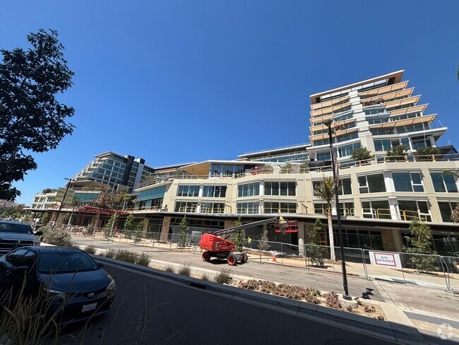
Property Record
222 City Dr N, , CA

Current Lease Availabilities
NEARBY LISTINGS FOR SALE OR LEASE
Property Detail
222 City Dr N
San Marcos
City Of San Marcos Tsm No. 210002
San Diego
LOT 3 TR 016612
San Diego-Chula Vista-Carlsbad, CA
San Diego
221-111-03
California
Multifamilydwelling
3
0
3.78 AC
2025
DEMOGRAPHICS near 222 City Dr N
1 mile
3 mile
5 mile
2024 Total Population
20,067
92,037
207,601
2029 Population
19,944
91,367
205,833
Pop Growth 2024-2029
(0.61%)
(0.73%)
(0.85%)
Average Age
32
38
39
2024 Total Households
5,913
29,837
69,400
HH Growth 2024-2029
(0.78%)
(0.85%)
(0.99%)
Median Household Inc
$80,720
$95,851
$89,832
Avg Household Size
3.10
2.90
2.90
2024 Avg HH Vehicles
2.00
2.00
2.00
Median Home Value
$696,734
$718,258
$730,916
Median Year Built
1995
1989
1986
Nearby Places
Map Layers
Map Styles
 Street
 Aerial
Transit
 Traffic
 Biking
Places
Listings with unknown addresses are not visible on the map
- Restaurants
- Banks
- Shops
- Fitness
- Groceries
PUBLIC TRANSPORTATION
TRANSIT/SUBWAY
Cal State San Marcos (Sprinter - San Diego North County Transit District (Coaster/Sprinter/Breeze))
Drive
Walk
Distance
Cal State San Marcos (Sprinter - San Diego North County Transit District (Coaster/Sprinter/Breeze))
2 min
10 min
0.5 mi
San Marcos Civic Center (Sprinter - San Diego North County Transit District (Coaster/Sprinter/Breeze))
Drive
Walk
Distance
San Marcos Civic Center (Sprinter - San Diego North County Transit District (Coaster/Sprinter/Breeze))
3 min
16 min
0.8 mi
AIRPORT
San Diego International
Drive
Walk
Distance
San Diego International
45 min
34.7 mi
Freight Ports
Port of San Diego
Drive
Walk
Distance
Port of San Diego
47 min
36.9 mi
Nearby Properties
Address
Land Use
TOTAL SIZE
Lot Size
Zoning
Address
Land Use
TOTAL SIZE
Lot Size
Zoning
27.98 AC
SPA
Address
Land Use
TOTAL SIZE
Lot Size
Zoning
15.37 AC
SPA
Address
Land Use
TOTAL SIZE
Lot Size
Zoning
5.25 AC
SPA
Address
Land Use
TOTAL SIZE
Lot Size
Zoning
5.37 AC
SPA
Address
Land Use
TOTAL SIZE
Lot Size
Zoning
10.82 AC
SPA
Address
Land Use
TOTAL SIZE
Lot Size
Zoning
Address
Land Use
TOTAL SIZE
Lot Size
Zoning
71,656 SF
S-P
Address
Land Use
TOTAL SIZE
Lot Size
Zoning
16.91 AC
C
Address
Land Use
TOTAL SIZE
Lot Size
Zoning
9.88 AC
R-3-10
Address
Land Use
TOTAL SIZE
Lot Size
Zoning
SPECIFIC P
Address
Land Use
TOTAL SIZE
Lot Size
Zoning
75,138 SF
C
Address
Land Use
TOTAL SIZE
Lot Size
Zoning
4.76 AC
C34
Address
Land Use
TOTAL SIZE
Lot Size
Zoning
80,064 SF
1.53 AC
S-P
Address
Land Use
TOTAL SIZE
Lot Size
Zoning
9.80 AC
I
Address
Land Use
TOTAL SIZE
Lot Size
Zoning
99,461 SF
4.89 AC
SPA
Address
Land Use
TOTAL SIZE
Lot Size
Zoning
10.80 AC
SPA
Address
Land Use
TOTAL SIZE
Lot Size
Zoning
1.94 AC
C
Address
Land Use
TOTAL SIZE
Lot Size
Zoning
9.99 AC
MU-1
Address
Land Use
TOTAL SIZE
Lot Size
Zoning
1.49 AC
SPA
Address
Land Use
TOTAL SIZE
Lot Size
Zoning
5.85 AC
SPA
Address
Land Use
TOTAL SIZE
Lot Size
Zoning
7.06 AC
SR
Address
Land Use
TOTAL SIZE
Lot Size
Zoning
95,713 SF
0.51 AC
C
Address
Land Use
TOTAL SIZE
Lot Size
Zoning
10.69 AC
R-3-10
Address
Land Use
TOTAL SIZE
Lot Size
Zoning
16.12 AC
SPA
Address
Land Use
TOTAL SIZE
Lot Size
Zoning
10.83 AC
SPA
Address
Land Use
TOTAL SIZE
Lot Size
Zoning
96,747 SF
3.34 AC
SPA
Address
Land Use
TOTAL SIZE
Lot Size
Zoning
4.79 AC
SR
Address
Land Use
TOTAL SIZE
Lot Size
Zoning
91,354 SF
2.66 AC
SPA
Address
Land Use
TOTAL SIZE
Lot Size
Zoning
99,500 SF
4.57 AC
SPA
Address
Land Use
TOTAL SIZE
Lot Size
Zoning
6.16 AC
SPA
The World's #1 Commercial Real Estate Marketplace
Connect with us
© 2026 CoStar Group
The information above has been obtained from sources believed reliable. While we do not doubt its accuracy we have not verified it and make no guarantee, warranty or representation about it. It is your responsibility to independently confirm its accuracy and completeness. Any projections, opinions, assumptions, or estimates used are for example only and do not represent the current or future performance of the property. The value of this transaction to you depends on tax and other factors which should be evaluated by your tax, financial, and legal advisors. You and your advisors should conduct a careful, independent investigation of the property to determine to your satisfaction the suitability of the property for your needs.