Property Record
222 E Mitchell St, San Antonio, TX 78210
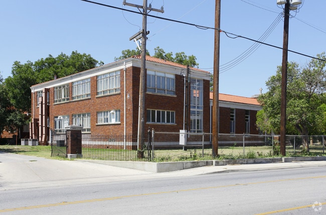

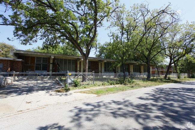
Property Detail
222 E Mitchell St
San Antonio-New Braunfels, TX
NCB 3975 BLK 1 LOT 34 (ST JOHNK UT-3), BLOCK 134 LOT 901 //DRAINAGE ACCESS// 2019-NEW PER PLAT 20001/256 FILED 7-13-18. JLF/GIS/8-2-18
03975-001-0340
BEXAR
Officebuilding
Texas
B and X Area of moderate flood hazard, usually the area between the limits of the 100-year and 500-year floods.
11
0
11.02 AC
2025
South
140300
San Antonio
48,624 SF
NEARBY LISTINGS FOR SALE OR LEASE
-
-
View all San Antonio listings for sale on LoopNet.com
DEMOGRAPHICS near 222 E Mitchell St
1 mile
3 mile
5 mile
2025 Total Population
13,433
146,896
345,793
2030 Population
14,524
155,140
365,217
Pop Growth 2025-2030
+ 8.12%
+ 5.61%
+ 5.62%
Average Age
40
39
38
2025 Total Households
5,058
53,046
123,549
HH Growth 2025-2030
+ 8.40%
+ 6.02%
+ 5.97%
Median Household Inc
$44,701
$46,032
$46,281
Avg Household Size
2.50
2.60
2.60
2025 Avg HH Vehicles
2.00
2.00
2.00
Median Home Value
$223,024
$160,741
$154,708
Median Year Built
1949
1955
1959
Nearby Places
Map Layers
Map Styles
 Street
 Aerial
Transit
 Traffic
 Biking
Places
Listings with unknown addresses are not visible on the map
- Restaurants
- Banks
- Shops
- Fitness
- Groceries
PUBLIC TRANSPORTATION
COMMUTER RAIL
San Antonio Amtrak Station (Sunset Limited - Amtrak, Texas Eagle - Amtrak)
Drive
Walk
Distance
San Antonio Amtrak Station (Sunset Limited - Amtrak, Texas Eagle - Amtrak)
6 min
2.9 mi
AIRPORT
San Antonio International
Drive
Walk
Distance
San Antonio International
15 min
10.8 mi
Freight Ports
Calhoun Port
Drive
Walk
Distance
Calhoun Port
180 min
146.8 mi
Nearby Properties
Address
Land Use
TOTAL SIZE
Lot Size
Zoning
Address
Land Use
TOTAL SIZE
Lot Size
Zoning
26.51 AC
Address
Land Use
TOTAL SIZE
Lot Size
Zoning
443,000 SF
4.16 AC
Address
Land Use
TOTAL SIZE
Lot Size
Zoning
738,650 SF
2.93 AC
Address
Land Use
TOTAL SIZE
Lot Size
Zoning
1,049,861 SF
1.50 AC
Address
Land Use
TOTAL SIZE
Lot Size
Zoning
922,468 SF
10.78 AC
Address
Land Use
TOTAL SIZE
Lot Size
Zoning
21,386 SF
1.03 AC
Address
Land Use
TOTAL SIZE
Lot Size
Zoning
443,560 SF
2.77 AC
Address
Land Use
TOTAL SIZE
Lot Size
Zoning
400,228 SF
0.78 AC
Address
Land Use
TOTAL SIZE
Lot Size
Zoning
290,794 SF
0.62 AC
Address
Land Use
TOTAL SIZE
Lot Size
Zoning
8.10 AC
Address
Land Use
TOTAL SIZE
Lot Size
Zoning
387,443 SF
0.89 AC
Address
Land Use
TOTAL SIZE
Lot Size
Zoning
254,108 SF
2.40 AC
Address
Land Use
TOTAL SIZE
Lot Size
Zoning
521,935 SF
2.17 AC
Address
Land Use
TOTAL SIZE
Lot Size
Zoning
495,840 SF
1.20 AC
Address
Land Use
TOTAL SIZE
Lot Size
Zoning
308,878 SF
1.23 AC
Address
Land Use
TOTAL SIZE
Lot Size
Zoning
15,468 SF
4.18 AC
Address
Land Use
TOTAL SIZE
Lot Size
Zoning
262,082 SF
1.60 AC
Address
Land Use
TOTAL SIZE
Lot Size
Zoning
7,018 SF
3.24 AC
Address
Land Use
TOTAL SIZE
Lot Size
Zoning
163,858 SF
0.62 AC
Address
Land Use
TOTAL SIZE
Lot Size
Zoning
481,589 SF
5.29 AC
Address
Land Use
TOTAL SIZE
Lot Size
Zoning
31,334 SF
14.11 AC
Address
Land Use
TOTAL SIZE
Lot Size
Zoning
399,007 SF
22.03 AC
Address
Land Use
TOTAL SIZE
Lot Size
Zoning
360,853 SF
1.18 AC
Address
Land Use
TOTAL SIZE
Lot Size
Zoning
156,480 SF
3.46 AC
Address
Land Use
TOTAL SIZE
Lot Size
Zoning
13,153 SF
2.62 AC
Address
Land Use
TOTAL SIZE
Lot Size
Zoning
349,678 SF
0.83 AC
Address
Land Use
TOTAL SIZE
Lot Size
Zoning
252,105 SF
0.47 AC
Address
Land Use
TOTAL SIZE
Lot Size
Zoning
240,394 SF
0.64 AC
Address
Land Use
TOTAL SIZE
Lot Size
Zoning
14,492 SF
6.62 AC
Address
Land Use
TOTAL SIZE
Lot Size
Zoning
291,374 SF
13.49 AC
The World's #1 Commercial Real Estate Marketplace
Connect with us
© 2026 CoStar Group
The information above has been obtained from sources believed reliable. While we do not doubt its accuracy we have not verified it and make no guarantee, warranty or representation about it. It is your responsibility to independently confirm its accuracy and completeness. Any projections, opinions, assumptions, or estimates used are for example only and do not represent the current or future performance of the property. The value of this transaction to you depends on tax and other factors which should be evaluated by your tax, financial, and legal advisors. You and your advisors should conduct a careful, independent investigation of the property to determine to your satisfaction the suitability of the property for your needs.