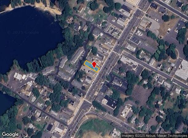
Property Record
222 Main St, Portland, CT 06480
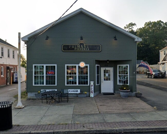
This Property Is For Sale
NEARBY LISTINGS FOR SALE OR LEASE
Property Detail
222 Main St
Storebuilding
Middlesex
X
Connecticut
09003C0650F
0.15 AC
2024
East Hampton/East Haddam
2025
Hartford
560200
Hartford-West Hartford-East Hartford, CT
3,585 SF
PORT-000019-000000-000049
DEMOGRAPHICS near 222 Main St
1 mile
3 mile
5 mile
2024 Total Population
4,894
39,235
73,902
2029 Population
4,888
38,966
73,571
Pop Growth 2024-2029
(0.12%)
(0.69%)
(0.45%)
Average Age
41
41
41
2024 Total Households
2,170
16,081
31,234
HH Growth 2024-2029
(0.09%)
(0.52%)
(0.42%)
Median Household Inc
$64,442
$73,572
$84,821
Avg Household Size
2.20
2.20
2.20
2024 Avg HH Vehicles
2.00
2.00
2.00
Median Home Value
$237,997
$257,100
$266,479
Median Year Built
1948
1957
1972
Nearby Places
Map Layers
Map Styles
 Street
 Aerial
Transit
 Traffic
 Biking
Places
Listings with unknown addresses are not visible on the map
- Restaurants
- Banks
- Shops
- Fitness
- Groceries
PUBLIC TRANSPORTATION
AIRPORT
Tweed/New Haven
Drive
Walk
Distance
Tweed/New Haven
45 min
31.1 mi
Bradley International
Drive
Walk
Distance
Bradley International
53 min
34.0 mi
Freight Ports
Port of New Haven
Drive
Walk
Distance
Port of New Haven
40 min
28.8 mi
Nearby Properties
Address
Land Use
TOTAL SIZE
Lot Size
Zoning
Address
Land Use
TOTAL SIZE
Lot Size
Zoning
12.12 AC
RPZ
Address
Land Use
TOTAL SIZE
Lot Size
Zoning
32 AC
R-45
Address
Land Use
TOTAL SIZE
Lot Size
Zoning
65.89 AC
R-45
Address
Land Use
TOTAL SIZE
Lot Size
Zoning
146.96 AC
I-3
Address
Land Use
TOTAL SIZE
Lot Size
Zoning
105 AC
R-45
Address
Land Use
TOTAL SIZE
Lot Size
Zoning
33,524 SF
37.71 AC
ID
Address
Land Use
TOTAL SIZE
Lot Size
Zoning
0.56 AC
B-1
Address
Land Use
TOTAL SIZE
Lot Size
Zoning
2.33 AC
ID
Address
Land Use
TOTAL SIZE
Lot Size
Zoning
267,588 SF
12.34 AC
ID
Address
Land Use
TOTAL SIZE
Lot Size
Zoning
27.21 AC
M
Address
Land Use
TOTAL SIZE
Lot Size
Zoning
4.90 AC
ID
Address
Land Use
TOTAL SIZE
Lot Size
Zoning
35.14 AC
R-30
Address
Land Use
TOTAL SIZE
Lot Size
Zoning
7.79 AC
ID
Address
Land Use
TOTAL SIZE
Lot Size
Zoning
1.62 AC
ID
Address
Land Use
TOTAL SIZE
Lot Size
Zoning
65,615 SF
1.46 AC
ID
Address
Land Use
TOTAL SIZE
Lot Size
Zoning
92,766 SF
1.79 AC
ID
Address
Land Use
TOTAL SIZE
Lot Size
Zoning
10.10 AC
IND
Address
Land Use
TOTAL SIZE
Lot Size
Zoning
3.58 AC
DVD
Address
Land Use
TOTAL SIZE
Lot Size
Zoning
3.24 AC
ID
Address
Land Use
TOTAL SIZE
Lot Size
Zoning
24.45 AC
HB
Address
Land Use
TOTAL SIZE
Lot Size
Zoning
2.49 AC
ID
Address
Land Use
TOTAL SIZE
Lot Size
Zoning
102,239 SF
1.02 AC
B-1
Address
Land Use
TOTAL SIZE
Lot Size
Zoning
91.69 AC
R-15
Address
Land Use
TOTAL SIZE
Lot Size
Zoning
83,241 SF
52.65 AC
R-15
Address
Land Use
TOTAL SIZE
Lot Size
Zoning
15.26 AC
MX
Address
Land Use
TOTAL SIZE
Lot Size
Zoning
67,405 SF
25 AC
R-15
Address
Land Use
TOTAL SIZE
Lot Size
Zoning
14.29 AC
MXC
Address
Land Use
TOTAL SIZE
Lot Size
Zoning
3.25 AC
ID
Address
Land Use
TOTAL SIZE
Lot Size
Zoning
80,627 SF
10.54 AC
HB
Address
Land Use
TOTAL SIZE
Lot Size
Zoning
18.50 AC
MXI
The World's #1 Commercial Real Estate Marketplace
Connect with us
© 2026 CoStar Group
The information above has been obtained from sources believed reliable. While we do not doubt its accuracy we have not verified it and make no guarantee, warranty or representation about it. It is your responsibility to independently confirm its accuracy and completeness. Any projections, opinions, assumptions, or estimates used are for example only and do not represent the current or future performance of the property. The value of this transaction to you depends on tax and other factors which should be evaluated by your tax, financial, and legal advisors. You and your advisors should conduct a careful, independent investigation of the property to determine to your satisfaction the suitability of the property for your needs.