Property Record
222 Martinel Dr, Kent, OH 44240
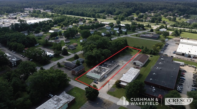


This Property Is For Sale
NEARBY LISTINGS FOR SALE OR LEASE
Property Detail
222 Martinel Dr
17-007-00-00-038-000
Davey Ind Park
Storebuilding
DAVEY IND PARK BLK B
X
Portage
39133C0138E
Ohio
2024
1.03 AC
2024
Portage County
601400
Cleveland
10,912 SF
Akron, OH
DEMOGRAPHICS near 222 Martinel Dr
1 Mile
3 Mile
5 Mile
2024 Total Population
6,887
41,871
91,994
2029 Population
6,949
42,458
92,304
Pop Growth 2024-2029
+ 0.90%
+ 1.40%
+ 0.34%
Average Age
35
35
40
2024 Total Households
3,467
16,950
37,633
HH Growth 2024-2029
+ 0.75%
+ 1.66%
+ 0.42%
Median Household Inc
$25,573
$49,967
$68,743
Avg Household Size
1.90
2.10
2.30
2024 Avg HH Vehicles
1.00
2.00
2.00
Median Home Value
$164,731
$214,647
$206,246
Median Year Built
1966
1974
1974
Nearby Places
Map Layers
Map Styles
 Street
 Aerial
- Restaurants
- Banks
- Shops
- Fitness
- Groceries
PUBLIC TRANSPORTATION
AIRPORT
Akron-Canton Regional
DRIVE
WALK
Distance
Akron-Canton Regional
32 min
23.1 mi
Cleveland-Hopkins International
DRIVE
WALK
Distance
Cleveland-Hopkins International
65 min
42.3 mi
Nearby Properties
Address
Land Use
TOTAL SIZE
Lot Size
Zoning
Address
Land Use
TOTAL SIZE
Lot Size
Zoning
871,059 SF
404.65 AC
Address
Land Use
TOTAL SIZE
Lot Size
Zoning
342,850 SF
86.98 AC
Address
Land Use
TOTAL SIZE
Lot Size
Zoning
139,790 SF
102.12 AC
Address
Land Use
TOTAL SIZE
Lot Size
Zoning
183,977 SF
10.12 AC
Address
Land Use
TOTAL SIZE
Lot Size
Zoning
86,411 SF
0.23 AC
Address
Land Use
TOTAL SIZE
Lot Size
Zoning
77,663 SF
83.47 AC
Address
Land Use
TOTAL SIZE
Lot Size
Zoning
815,100 SF
66.78 AC
Address
Land Use
TOTAL SIZE
Lot Size
Zoning
173,811 SF
9.34 AC
Address
Land Use
TOTAL SIZE
Lot Size
Zoning
61,748 SF
17.12 AC
Address
Land Use
TOTAL SIZE
Lot Size
Zoning
57,908 SF
6.36 AC
Address
Land Use
TOTAL SIZE
Lot Size
Zoning
141,562 SF
1.63 AC
Address
Land Use
TOTAL SIZE
Lot Size
Zoning
150,616 SF
12.63 AC
Address
Land Use
TOTAL SIZE
Lot Size
Zoning
213,347 SF
30.75 AC
Address
Land Use
TOTAL SIZE
Lot Size
Zoning
146,435 SF
59.76 AC
Address
Land Use
TOTAL SIZE
Lot Size
Zoning
278,319 SF
34.50 AC
Address
Land Use
TOTAL SIZE
Lot Size
Zoning
68,754 SF
25.80 AC
Address
Land Use
TOTAL SIZE
Lot Size
Zoning
179,055 SF
19.68 AC
Address
Land Use
TOTAL SIZE
Lot Size
Zoning
28,438 SF
9 AC
Address
Land Use
TOTAL SIZE
Lot Size
Zoning
193,894 SF
24.63 AC
Address
Land Use
TOTAL SIZE
Lot Size
Zoning
310,705 SF
9.96 AC
Address
Land Use
TOTAL SIZE
Lot Size
Zoning
216,994 SF
10.94 AC
Address
Land Use
TOTAL SIZE
Lot Size
Zoning
161,806 SF
1.92 AC
Address
Land Use
TOTAL SIZE
Lot Size
Zoning
52,575 SF
1.33 AC
Address
Land Use
TOTAL SIZE
Lot Size
Zoning
89,449 SF
14.59 AC
Address
Land Use
TOTAL SIZE
Lot Size
Zoning
91,286 SF
27.27 AC
Address
Land Use
TOTAL SIZE
Lot Size
Zoning
34,394 SF
3.59 AC
Address
Land Use
TOTAL SIZE
Lot Size
Zoning
78,446 SF
18.02 AC
Address
Land Use
TOTAL SIZE
Lot Size
Zoning
212,628 SF
27.25 AC
Address
Land Use
TOTAL SIZE
Lot Size
Zoning
176,320 SF
1.73 AC
Address
Land Use
TOTAL SIZE
Lot Size
Zoning
33,561 SF
2.62 AC
The World's #1 Commercial Real Estate Marketplace
Connect with us
© 2025 CoStar Group
The information above has been obtained from sources believed reliable. While we do not doubt its accuracy we have not verified it and make no guarantee, warranty or representation about it. It is your responsibility to independently confirm its accuracy and completeness. Any projections, opinions, assumptions, or estimates used are for example only and do not represent the current or future performance of the property. The value of this transaction to you depends on tax and other factors which should be evaluated by your tax, financial, and legal advisors. You and your advisors should conduct a careful, independent investigation of the property to determine to your satisfaction the suitability of the property for your needs.