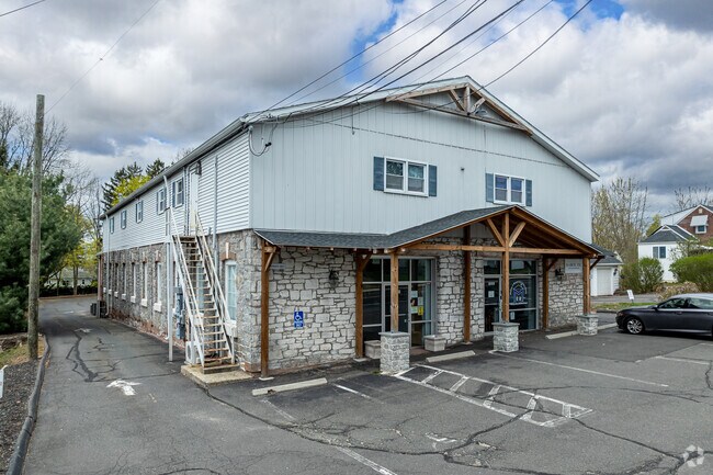
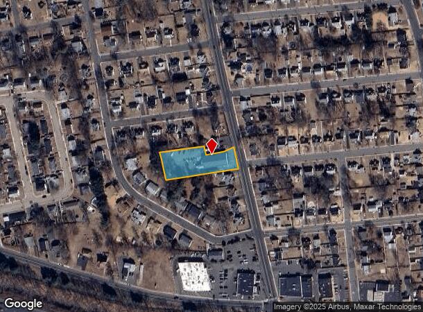
Property Record
222 Mckee St, Manchester, CT 06040
Current Lease Availabilities
NEARBY LISTINGS FOR SALE OR LEASE
Property Detail
222 Mckee St
MANC-000048-003890-000222
Hartford
Commercialbuilding
Connecticut
X
222
09003C0393F
0.75 AC
2025
Manchester
2025
Hartford
514600
Hartford-West Hartford-East Hartford, CT
11,128 SF
DEMOGRAPHICS near 222 Mckee St
1 mile
3 mile
5 mile
2024 Total Population
12,681
65,947
137,499
2029 Population
12,625
65,732
136,899
Pop Growth 2024-2029
(0.44%)
(0.33%)
(0.44%)
Average Age
40
40
40
2024 Total Households
5,421
26,804
55,715
HH Growth 2024-2029
(0.65%)
(0.38%)
(0.49%)
Median Household Inc
$60,849
$78,808
$81,828
Avg Household Size
2.20
2.40
2.40
2024 Avg HH Vehicles
1.00
2.00
2.00
Median Home Value
$171,477
$216,522
$237,379
Median Year Built
1951
1960
1966
Nearby Places
Map Layers
Map Styles
 Street
 Aerial
Transit
 Traffic
 Biking
Places
Listings with unknown addresses are not visible on the map
- Restaurants
- Banks
- Shops
- Fitness
- Groceries
PUBLIC TRANSPORTATION
COMMUTER RAIL
Drive
Walk
Distance
12 min
8.1 mi
Drive
Walk
Distance
12 min
8.1 mi
AIRPORT
Bradley International
Drive
Walk
Distance
Bradley International
39 min
22.5 mi
Freight Ports
Port of New Haven
Drive
Walk
Distance
Port of New Haven
58 min
44.6 mi
Nearby Properties
Address
Land Use
TOTAL SIZE
Lot Size
Zoning
Address
Land Use
TOTAL SIZE
Lot Size
Zoning
159 AC
RR
Address
Land Use
TOTAL SIZE
Lot Size
Zoning
12.54 AC
Address
Land Use
TOTAL SIZE
Lot Size
Zoning
194,971 SF
162.43 AC
IND
Address
Land Use
TOTAL SIZE
Lot Size
Zoning
467,349 SF
13.83 AC
CUD
Address
Land Use
TOTAL SIZE
Lot Size
Zoning
20,384 SF
40 AC
PRD
Address
Land Use
TOTAL SIZE
Lot Size
Zoning
43.60 AC
PRD
Address
Land Use
TOTAL SIZE
Lot Size
Zoning
29,744 SF
29.50 AC
PRD
Address
Land Use
TOTAL SIZE
Lot Size
Zoning
26.65 AC
GB
Address
Land Use
TOTAL SIZE
Lot Size
Zoning
1,920 SF
31 AC
RC
Address
Land Use
TOTAL SIZE
Lot Size
Zoning
29.90 AC
PRD
Address
Land Use
TOTAL SIZE
Lot Size
Zoning
53.59 AC
RA
Address
Land Use
TOTAL SIZE
Lot Size
Zoning
219,479 SF
9.32 AC
H
Address
Land Use
TOTAL SIZE
Lot Size
Zoning
498,105 SF
29.55 AC
IND
Address
Land Use
TOTAL SIZE
Lot Size
Zoning
19.60 AC
GB
Address
Land Use
TOTAL SIZE
Lot Size
Zoning
36 AC
RR
Address
Land Use
TOTAL SIZE
Lot Size
Zoning
22.12 AC
FBZ
Address
Land Use
TOTAL SIZE
Lot Size
Zoning
68,988 SF
9.17 AC
GB
Address
Land Use
TOTAL SIZE
Lot Size
Zoning
13,056 SF
17.43 AC
RB
Address
Land Use
TOTAL SIZE
Lot Size
Zoning
76,768 SF
6.03 AC
R-2
Address
Land Use
TOTAL SIZE
Lot Size
Zoning
187,657 SF
30.80 AC
RR
Address
Land Use
TOTAL SIZE
Lot Size
Zoning
6.38 AC
CBD
Address
Land Use
TOTAL SIZE
Lot Size
Zoning
79,198 SF
10.47 AC
RA
Address
Land Use
TOTAL SIZE
Lot Size
Zoning
195,772 SF
3.17 AC
H
Address
Land Use
TOTAL SIZE
Lot Size
Zoning
13.01 AC
B5
Address
Land Use
TOTAL SIZE
Lot Size
Zoning
106,380 SF
12.55 AC
CUD
Address
Land Use
TOTAL SIZE
Lot Size
Zoning
144,679 SF
16.39 AC
CUD
Address
Land Use
TOTAL SIZE
Lot Size
Zoning
6,612 SF
22 AC
RA
Address
Land Use
TOTAL SIZE
Lot Size
Zoning
72,383 SF
14.10 AC
RR/RB
Address
Land Use
TOTAL SIZE
Lot Size
Zoning
6.80 AC
H
Address
Land Use
TOTAL SIZE
Lot Size
Zoning
513,264 SF
34.88 AC
I-2
The World's #1 Commercial Real Estate Marketplace
Connect with us
© 2026 CoStar Group
The information above has been obtained from sources believed reliable. While we do not doubt its accuracy we have not verified it and make no guarantee, warranty or representation about it. It is your responsibility to independently confirm its accuracy and completeness. Any projections, opinions, assumptions, or estimates used are for example only and do not represent the current or future performance of the property. The value of this transaction to you depends on tax and other factors which should be evaluated by your tax, financial, and legal advisors. You and your advisors should conduct a careful, independent investigation of the property to determine to your satisfaction the suitability of the property for your needs.