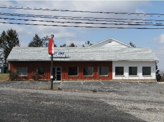
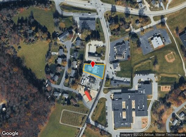
Property Record
222 N Main St, York, PA 17403
NEARBY LISTINGS FOR SALE OR LEASE
-
-
View all York listings for sale on LoopNet.com
Property Detail
222 N Main St
75-000-03-0016.00-00000
C S Davidson Inc Civil Engineers
Storebuilding
LOT 1; RR-715
X
York
42133C0455F
Pennsylvania
2025
0.41 AC
2025
York County
022601
Philadelphia
5,849 SF
York-Hanover, PA
DEMOGRAPHICS near 222 N Main St
1 Mile
3 Mile
5 Mile
2024 Total Population
3,266
9,477
39,448
2029 Population
3,328
9,634
40,342
Pop Growth 2024-2029
+ 1.90%
+ 1.66%
+ 2.27%
Average Age
40
41
42
2024 Total Households
1,187
3,463
15,498
HH Growth 2024-2029
+ 1.94%
+ 1.70%
+ 2.36%
Median Household Inc
$106,951
$105,031
$80,652
Avg Household Size
2.80
2.70
2.50
2024 Avg HH Vehicles
2.00
2.00
2.00
Median Home Value
$271,344
$262,328
$232,409
Median Year Built
1986
1977
1974
Nearby Places
Map Layers
Map Styles
 Street
 Aerial
- Restaurants
- Banks
- Shops
- Fitness
- Groceries
PUBLIC TRANSPORTATION
AIRPORT
Harrisburg International
DRIVE
WALK
Distance
Harrisburg International
53 min
39.2 mi
Freight Ports
Port of Baltimore
DRIVE
WALK
Distance
Port of Baltimore
68 min
48.1 mi
Nearby Properties
Address
Land Use
TOTAL SIZE
Lot Size
Zoning
Address
Land Use
TOTAL SIZE
Lot Size
Zoning
106,160 SF
38.70 AC
AG
Address
Land Use
TOTAL SIZE
Lot Size
Zoning
56,290 SF
13.63 AC
ID
Address
Land Use
TOTAL SIZE
Lot Size
Zoning
6.72 AC
RS
Address
Land Use
TOTAL SIZE
Lot Size
Zoning
31,708 SF
2.50 AC
Address
Land Use
TOTAL SIZE
Lot Size
Zoning
21,000 SF
4.84 AC
ID
Address
Land Use
TOTAL SIZE
Lot Size
Zoning
44,643 SF
6.36 AC
I
Address
Land Use
TOTAL SIZE
Lot Size
Zoning
1,600 SF
1.43 AC
Address
Land Use
TOTAL SIZE
Lot Size
Zoning
65,338 SF
15 AC
AG
Address
Land Use
TOTAL SIZE
Lot Size
Zoning
7,420 SF
13.14 AC
AG
Address
Land Use
TOTAL SIZE
Lot Size
Zoning
5,520 SF
5.50 AC
RS
Address
Land Use
TOTAL SIZE
Lot Size
Zoning
9.89 AC
ROS
Address
Land Use
TOTAL SIZE
Lot Size
Zoning
31,320 SF
1.22 AC
CM
Address
Land Use
TOTAL SIZE
Lot Size
Zoning
28,600 SF
10.68 AC
ID
Address
Land Use
TOTAL SIZE
Lot Size
Zoning
36,000 SF
4.79 AC
ID
Address
Land Use
TOTAL SIZE
Lot Size
Zoning
8,815 SF
2.11 AC
CM
Address
Land Use
TOTAL SIZE
Lot Size
Zoning
8,427 SF
48.65 AC
RS
Address
Land Use
TOTAL SIZE
Lot Size
Zoning
35,801 SF
3.67 AC
ID
Address
Land Use
TOTAL SIZE
Lot Size
Zoning
9,984 SF
5.17 AC
RS
Address
Land Use
TOTAL SIZE
Lot Size
Zoning
4,214 SF
93.95 AC
AG
Address
Land Use
TOTAL SIZE
Lot Size
Zoning
2,040 SF
152.14 AC
AG
Address
Land Use
TOTAL SIZE
Lot Size
Zoning
3.11 AC
ID
Address
Land Use
TOTAL SIZE
Lot Size
Zoning
5,954 SF
19.55 AC
RS
Address
Land Use
TOTAL SIZE
Lot Size
Zoning
11,848 SF
0.27 AC
AG
Address
Land Use
TOTAL SIZE
Lot Size
Zoning
11,359 SF
0.22 AC
CM
Address
Land Use
TOTAL SIZE
Lot Size
Zoning
1,536 SF
3.44 AC
ID
Address
Land Use
TOTAL SIZE
Lot Size
Zoning
3,096 SF
53.67 AC
C
Address
Land Use
TOTAL SIZE
Lot Size
Zoning
12,200 SF
2.44 AC
CM
Address
Land Use
TOTAL SIZE
Lot Size
Zoning
3,858 SF
90.65 AC
AG
Address
Land Use
TOTAL SIZE
Lot Size
Zoning
6,544 SF
132.75 AC
CM
Address
Land Use
TOTAL SIZE
Lot Size
Zoning
6,681 SF
29.27 AC
RS
The World's #1 Commercial Real Estate Marketplace
Connect with us
© 2025 CoStar Group
The information above has been obtained from sources believed reliable. While we do not doubt its accuracy we have not verified it and make no guarantee, warranty or representation about it. It is your responsibility to independently confirm its accuracy and completeness. Any projections, opinions, assumptions, or estimates used are for example only and do not represent the current or future performance of the property. The value of this transaction to you depends on tax and other factors which should be evaluated by your tax, financial, and legal advisors. You and your advisors should conduct a careful, independent investigation of the property to determine to your satisfaction the suitability of the property for your needs.