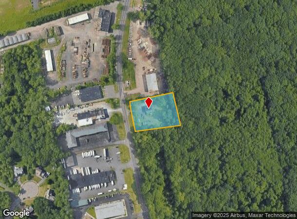
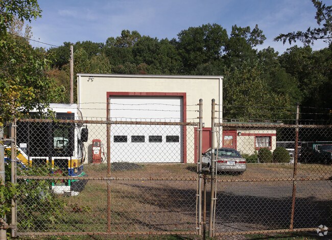
Property Record
222 Shunpike Rd, Cromwell, CT 06416

NEARBY LISTINGS FOR SALE OR LEASE
Property Detail
222 Shunpike Rd
CROM-000025-000015-000004
Middlesex
Commercialbuilding
Connecticut
A
4
09003C0518F
1.26 AC
2025
NW Middlesex/Mid'town
2025
Hartford
570200
Hartford-West Hartford-East Hartford, CT
1,484 SF
DEMOGRAPHICS near 222 Shunpike Rd
1 mile
3 mile
5 mile
2024 Total Population
5,016
41,116
109,495
2029 Population
5,083
41,065
108,955
Pop Growth 2024-2029
+ 1.34%
(0.12%)
(0.49%)
Average Age
37
42
43
2024 Total Households
2,093
17,853
46,239
HH Growth 2024-2029
+ 1.48%
(0.16%)
(0.51%)
Median Household Inc
$100,737
$90,084
$91,361
Avg Household Size
2.40
2.20
2.30
2024 Avg HH Vehicles
1.00
2.00
2.00
Median Home Value
$291,966
$288,212
$280,813
Median Year Built
1978
1979
1973
Nearby Places
Map Layers
Map Styles
 Street
 Aerial
Transit
 Traffic
 Biking
Places
Listings with unknown addresses are not visible on the map
- Restaurants
- Banks
- Shops
- Fitness
- Groceries
PUBLIC TRANSPORTATION
COMMUTER RAIL
Drive
Walk
Distance
13 min
7.9 mi
Drive
Walk
Distance
14 min
7.9 mi
AIRPORT
Bradley International
Drive
Walk
Distance
Bradley International
47 min
28.1 mi
Tweed/New Haven
Drive
Walk
Distance
Tweed/New Haven
47 min
32.4 mi
Freight Ports
Port of New Haven
Drive
Walk
Distance
Port of New Haven
43 min
30.1 mi
Nearby Properties
Address
Land Use
TOTAL SIZE
Lot Size
Zoning
Address
Land Use
TOTAL SIZE
Lot Size
Zoning
109,079 SF
110.62 AC
OT
Address
Land Use
TOTAL SIZE
Lot Size
Zoning
24.70 AC
R-20
Address
Land Use
TOTAL SIZE
Lot Size
Zoning
81,507 SF
21.60 AC
R-20
Address
Land Use
TOTAL SIZE
Lot Size
Zoning
117,178 SF
13.02 AC
R-20
Address
Land Use
TOTAL SIZE
Lot Size
Zoning
33,524 SF
37.71 AC
ID
Address
Land Use
TOTAL SIZE
Lot Size
Zoning
33.30 AC
R-20
Address
Land Use
TOTAL SIZE
Lot Size
Zoning
43.15 AC
R-20
Address
Land Use
TOTAL SIZE
Lot Size
Zoning
17.38 AC
PRD
Address
Land Use
TOTAL SIZE
Lot Size
Zoning
29.45 AC
R-15
Address
Land Use
TOTAL SIZE
Lot Size
Zoning
248,626 SF
92.26 AC
BP-2
Address
Land Use
TOTAL SIZE
Lot Size
Zoning
403,000 SF
33.55 AC
IND
Address
Land Use
TOTAL SIZE
Lot Size
Zoning
23.08 AC
BP-2
Address
Land Use
TOTAL SIZE
Lot Size
Zoning
87,037 SF
10.44 AC
R-20
Address
Land Use
TOTAL SIZE
Lot Size
Zoning
Address
Land Use
TOTAL SIZE
Lot Size
Zoning
15.10 AC
PRD
Address
Land Use
TOTAL SIZE
Lot Size
Zoning
19.49 AC
PRD
Address
Land Use
TOTAL SIZE
Lot Size
Zoning
310,582 SF
32.72 AC
OP
Address
Land Use
TOTAL SIZE
Lot Size
Zoning
27,152 SF
8.75 AC
R-25
Address
Land Use
TOTAL SIZE
Lot Size
Zoning
9.81 AC
OP
Address
Land Use
TOTAL SIZE
Lot Size
Zoning
1.99 AC
C
Address
Land Use
TOTAL SIZE
Lot Size
Zoning
24.45 AC
HB
Address
Land Use
TOTAL SIZE
Lot Size
Zoning
13.28 AC
PRD
Address
Land Use
TOTAL SIZE
Lot Size
Zoning
38,860 SF
38.47 AC
PS-B
Address
Land Use
TOTAL SIZE
Lot Size
Zoning
10.45 AC
R-20
Address
Land Use
TOTAL SIZE
Lot Size
Zoning
83,468 SF
6.65 AC
R-20
Address
Land Use
TOTAL SIZE
Lot Size
Zoning
145,956 SF
11.27 AC
OP
Address
Land Use
TOTAL SIZE
Lot Size
Zoning
13.85 AC
R-20
Address
Land Use
TOTAL SIZE
Lot Size
Zoning
49,724 SF
9.02 AC
OP
Address
Land Use
TOTAL SIZE
Lot Size
Zoning
15.50 AC
PRD
Address
Land Use
TOTAL SIZE
Lot Size
Zoning
161,959 SF
45.61 AC
R-25
The World's #1 Commercial Real Estate Marketplace
Connect with us
© 2026 CoStar Group
The information above has been obtained from sources believed reliable. While we do not doubt its accuracy we have not verified it and make no guarantee, warranty or representation about it. It is your responsibility to independently confirm its accuracy and completeness. Any projections, opinions, assumptions, or estimates used are for example only and do not represent the current or future performance of the property. The value of this transaction to you depends on tax and other factors which should be evaluated by your tax, financial, and legal advisors. You and your advisors should conduct a careful, independent investigation of the property to determine to your satisfaction the suitability of the property for your needs.