Property Record
222 Swindall Rd, Troy, AL 36081
Save to a Folder
{{folder.Name}}
{{folder.ListingIds.length}} Properties
{{folder.ListingIds.length}} Property
Create a New Folder
Property Detail
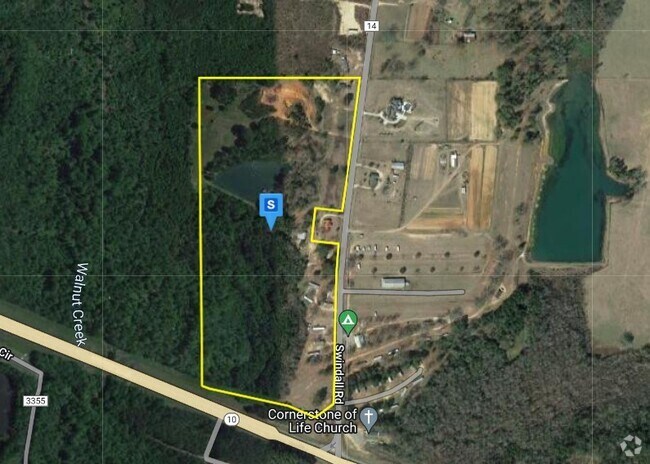
222 Swindall Rd
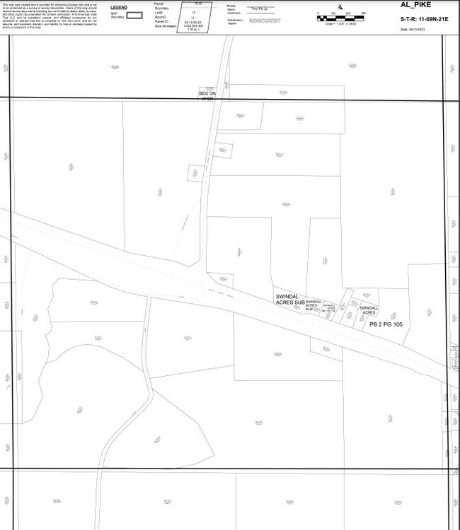
1701-1100000-040000
4.85 AC BEG AT NE COR OF NE1/4 OF NW1/43 SEC11 T9N R21E TH W78.01 TO E ROW OF PIKE COUNTY RAOD 5516 TH ALG ROW SW420' S11 T9N
Communitycenter
PIKE
S
Alabama
A Areas with a 1% annual chance of flooding and a 26% chance of flooding over the life of a 30-year mortgage.
33 AC
2025
Alabama South Area
2025
Other Market Areas
189102
Troy, AL
8,400 SF
NEARBY LISTINGS FOR SALE OR LEASE
DEMOGRAPHICS near 222 Swindall Rd
1 mile
3 mile
5 mile
2025 Total Population
412
6,354
18,152
2030 Population
413
6,396
18,337
Pop Growth 2025-2030
+ 0.24%
+ 0.66%
+ 1.02%
Average Age
36
36
36
2025 Total Households
193
2,768
7,591
HH Growth 2025-2030
0.00%
+ 0.65%
+ 1.13%
Median Household Inc
$48,214
$41,281
$45,947
Avg Household Size
2.00
2.10
2.10
2025 Avg HH Vehicles
2.00
2.00
2.00
Median Home Value
$236,000
$210,606
$209,760
Median Year Built
1989
1989
1987
Nearby Places
Map Layers
Map Styles
 Street
 Aerial
Layers
 Traffic
 Biking
Places
Listings with unknown addresses are not visible on the map
- Restaurants
- Banks
- Shops
- Fitness
- Groceries
Nearby Properties
Address
Land Use
TOTAL SIZE
Lot Size
Zoning
Address
Land Use
TOTAL SIZE
Lot Size
Zoning
14,100 SF
6.55 AC
C
Address
Land Use
TOTAL SIZE
Lot Size
Zoning
189,273 SF
21.24 AC
Address
Land Use
TOTAL SIZE
Lot Size
Zoning
14,152 SF
12.71 AC
O
Address
Land Use
TOTAL SIZE
Lot Size
Zoning
111,427 SF
14.90 AC
Address
Land Use
TOTAL SIZE
Lot Size
Zoning
2,932 SF
6.50 AC
M
Address
Land Use
TOTAL SIZE
Lot Size
Zoning
99,332 SF
11.06 AC
C
Address
Land Use
TOTAL SIZE
Lot Size
Zoning
70.29 AC
Address
Land Use
TOTAL SIZE
Lot Size
Zoning
68,466 SF
3.03 AC
C
Address
Land Use
TOTAL SIZE
Lot Size
Zoning
11,139 SF
2.50 AC
S
Address
Land Use
TOTAL SIZE
Lot Size
Zoning
14,395 SF
2.18 AC
Address
Land Use
TOTAL SIZE
Lot Size
Zoning
20,590 SF
14.80 AC
C
Address
Land Use
TOTAL SIZE
Lot Size
Zoning
10,633 SF
2.79 AC
C
Address
Land Use
TOTAL SIZE
Lot Size
Zoning
33,105 SF
0.50 AC
S
Address
Land Use
TOTAL SIZE
Lot Size
Zoning
15,320 SF
1.88 AC
S
Address
Land Use
TOTAL SIZE
Lot Size
Zoning
66,591 SF
8.02 AC
C
Address
Land Use
TOTAL SIZE
Lot Size
Zoning
54,438 SF
5.11 AC
C
Address
Land Use
TOTAL SIZE
Lot Size
Zoning
14,143 SF
4.10 AC
N
Address
Land Use
TOTAL SIZE
Lot Size
Zoning
4,140 SF
1.97 AC
C
Address
Land Use
TOTAL SIZE
Lot Size
Zoning
7,701 SF
Address
Land Use
TOTAL SIZE
Lot Size
Zoning
9,416 SF
1.38 AC
Address
Land Use
TOTAL SIZE
Lot Size
Zoning
5,920 SF
5 AC
C
Address
Land Use
TOTAL SIZE
Lot Size
Zoning
4,960 SF
2.80 AC
Address
Land Use
TOTAL SIZE
Lot Size
Zoning
3,579 SF
1.31 AC
C
Address
Land Use
TOTAL SIZE
Lot Size
Zoning
6,062 SF
1.96 AC
C
Address
Land Use
TOTAL SIZE
Lot Size
Zoning
5,000 SF
8.01 AC
Address
Land Use
TOTAL SIZE
Lot Size
Zoning
10,000 SF
39.10 AC
O
Address
Land Use
TOTAL SIZE
Lot Size
Zoning
6,550 SF
Address
Land Use
TOTAL SIZE
Lot Size
Zoning
4,716 SF
0.96 AC
M
The World's #1 Commercial Real Estate Marketplace
Connect with us
© 2026 CoStar Group
The information above has been obtained from sources believed reliable. While we do not doubt its accuracy we have not verified it and make no guarantee, warranty or representation about it. It is your responsibility to independently confirm its accuracy and completeness. Any projections, opinions, assumptions, or estimates used are for example only and do not represent the current or future performance of the property. The value of this transaction to you depends on tax and other factors which should be evaluated by your tax, financial, and legal advisors. You and your advisors should conduct a careful, independent investigation of the property to determine to your satisfaction the suitability of the property for your needs.