Property Record
222 W 2Nd St, Ottumwa, IA 52501

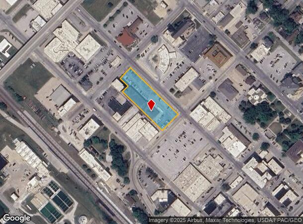
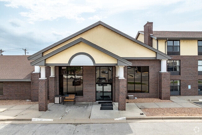
This Property Is For Sale
NEARBY LISTINGS FOR SALE OR LEASE
-
-
View all Ottumwa listings for sale on LoopNet.com
Property Detail
222 W 2Nd St
Other Market Areas
Ottumwa Orig
Ottumwa, IA
OTTUMWA ORIGINAL NE 88'LOT 227 BLK 25 & ALL OF LOTS 228-232 BLK 25(222 W SECOND)
007413760193000
Wapello
Hotelormotel
Iowa
2025
227-232
2025
1.13 AC
960600
Iowa Southeast Area
23,940 SF
DEMOGRAPHICS near 222 W 2Nd St
1 Mile
3 Mile
5 Mile
2024 Total Population
6,403
26,269
28,392
2029 Population
6,338
25,824
27,895
Pop Growth 2024-2029
(1.02%)
(1.69%)
(1.75%)
Average Age
36
39
39
2024 Total Households
2,493
10,440
11,270
HH Growth 2024-2029
(1.16%)
(1.76%)
(1.81%)
Median Household Inc
$48,825
$49,242
$50,320
Avg Household Size
2.40
2.40
2.40
2024 Avg HH Vehicles
2.00
2.00
2.00
Median Home Value
$89,493
$87,728
$93,084
Median Year Built
1948
1953
1954
Nearby Places
Map Layers
Map Styles
 Street
 Aerial
- Restaurants
- Banks
- Shops
- Fitness
- Groceries
PUBLIC TRANSPORTATION
COMMUTER RAIL
Ottumwa Amtrak Station (California Zephyr - Amtrak)
DRIVE
WALK
Distance
Ottumwa Amtrak Station (California Zephyr - Amtrak)
0 min
3 min
0.2 mi
Freight Ports
Port Milwaukee
DRIVE
WALK
Distance
Port Milwaukee
405 min
350.3 mi
Nearby Properties
Address
Land Use
TOTAL SIZE
Lot Size
Zoning
Address
Land Use
TOTAL SIZE
Lot Size
Zoning
1,680 SF
17.26 AC
Address
Land Use
TOTAL SIZE
Lot Size
Zoning
97,103 SF
0.35 AC
Address
Land Use
TOTAL SIZE
Lot Size
Zoning
527,878 SF
28.50 AC
Address
Land Use
TOTAL SIZE
Lot Size
Zoning
209,420 SF
24.98 AC
Address
Land Use
TOTAL SIZE
Lot Size
Zoning
194,348 SF
19.28 AC
Address
Land Use
TOTAL SIZE
Lot Size
Zoning
1.01 AC
Address
Land Use
TOTAL SIZE
Lot Size
Zoning
34,134 SF
9.89 AC
Address
Land Use
TOTAL SIZE
Lot Size
Zoning
32,796 SF
5.10 AC
Address
Land Use
TOTAL SIZE
Lot Size
Zoning
161,539 SF
5.43 AC
Address
Land Use
TOTAL SIZE
Lot Size
Zoning
96,024 SF
19.93 AC
Address
Land Use
TOTAL SIZE
Lot Size
Zoning
87,967 SF
4.28 AC
Address
Land Use
TOTAL SIZE
Lot Size
Zoning
41,660 SF
0.55 AC
Address
Land Use
TOTAL SIZE
Lot Size
Zoning
42,256 SF
18.04 AC
Address
Land Use
TOTAL SIZE
Lot Size
Zoning
53,552 SF
1.92 AC
Address
Land Use
TOTAL SIZE
Lot Size
Zoning
24,094 SF
4 AC
Address
Land Use
TOTAL SIZE
Lot Size
Zoning
47,341 SF
2.33 AC
Address
Land Use
TOTAL SIZE
Lot Size
Zoning
51,520 SF
8.37 AC
Address
Land Use
TOTAL SIZE
Lot Size
Zoning
12,620 SF
4.87 AC
Address
Land Use
TOTAL SIZE
Lot Size
Zoning
55,481 SF
8.65 AC
Address
Land Use
TOTAL SIZE
Lot Size
Zoning
86,534 SF
8.77 AC
Address
Land Use
TOTAL SIZE
Lot Size
Zoning
7,995 SF
0.14 AC
Address
Land Use
TOTAL SIZE
Lot Size
Zoning
36,586 SF
0.15 AC
Address
Land Use
TOTAL SIZE
Lot Size
Zoning
3,440 SF
3.95 AC
Address
Land Use
TOTAL SIZE
Lot Size
Zoning
61,540 SF
14.65 AC
Address
Land Use
TOTAL SIZE
Lot Size
Zoning
49,084 SF
3.87 AC
Address
Land Use
TOTAL SIZE
Lot Size
Zoning
28,476 SF
30.05 AC
Address
Land Use
TOTAL SIZE
Lot Size
Zoning
40,939 SF
5.72 AC
Address
Land Use
TOTAL SIZE
Lot Size
Zoning
18,457 SF
0.57 AC
Address
Land Use
TOTAL SIZE
Lot Size
Zoning
33,060 SF
3.83 AC
Address
Land Use
TOTAL SIZE
Lot Size
Zoning
23,858 SF
3.53 AC
The World's #1 Commercial Real Estate Marketplace
Connect with us
© 2026 CoStar Group
The information above has been obtained from sources believed reliable. While we do not doubt its accuracy we have not verified it and make no guarantee, warranty or representation about it. It is your responsibility to independently confirm its accuracy and completeness. Any projections, opinions, assumptions, or estimates used are for example only and do not represent the current or future performance of the property. The value of this transaction to you depends on tax and other factors which should be evaluated by your tax, financial, and legal advisors. You and your advisors should conduct a careful, independent investigation of the property to determine to your satisfaction the suitability of the property for your needs.