Property Record
222 W Main St, Wilmington, OH 45177

NEARBY LISTINGS FOR SALE OR LEASE
-
-
View all Wilmington listings for sale on LoopNet.com
Property Detail
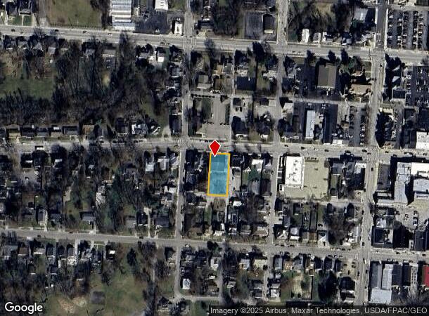
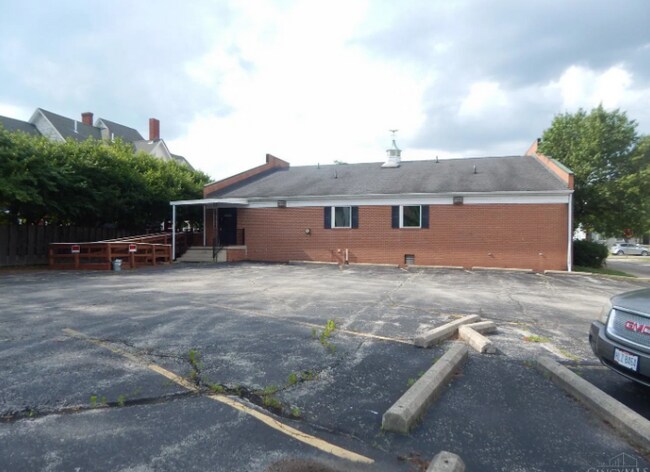
222 W Main St
Wilmington, OH
Thatchers Add
290-25-02-09-0003-00
THATCHERS ADD LT3WH
Medicalbuilding
Clinton
X
Ohio
39027C0129E
3
2024
0.34 AC
2024
Ohio South Area
964600
Other Market Areas
3,684 SF
DEMOGRAPHICS near 222 W Main St
1 Mile
3 Mile
5 Mile
2024 Total Population
9,388
15,328
18,867
2029 Population
9,588
15,603
19,082
Pop Growth 2024-2029
+ 2.13%
+ 1.79%
+ 1.14%
Average Age
39
40
40
2024 Total Households
3,857
6,205
7,555
HH Growth 2024-2029
+ 2.31%
+ 1.92%
+ 1.23%
Median Household Inc
$45,564
$48,918
$52,973
Avg Household Size
2.20
2.20
2.30
2024 Avg HH Vehicles
2.00
2.00
2.00
Median Home Value
$147,149
$164,351
$176,186
Median Year Built
1971
1978
1979
Nearby Places
Map Layers
Map Styles
 Street
 Aerial
- Restaurants
- Banks
- Shops
- Fitness
- Groceries
PUBLIC TRANSPORTATION
AIRPORT
James M Cox Dayton International
DRIVE
WALK
Distance
James M Cox Dayton International
70 min
46.3 mi
SALE & LEASE HISTORY
LISTING DATE
SALE/LEASE

Oct 01, 2024
For Sale
Nearby Properties
Address
Land Use
TOTAL SIZE
Lot Size
Zoning
Address
Land Use
TOTAL SIZE
Lot Size
Zoning
3,024 SF
0.01 AC
Address
Land Use
TOTAL SIZE
Lot Size
Zoning
42,621 SF
26.45 AC
Address
Land Use
TOTAL SIZE
Lot Size
Zoning
108,293 SF
1,048.03 AC
Address
Land Use
TOTAL SIZE
Lot Size
Zoning
51,587 SF
46.77 AC
I2
Address
Land Use
TOTAL SIZE
Lot Size
Zoning
126,712 SF
26.63 AC
Address
Land Use
TOTAL SIZE
Lot Size
Zoning
112,625 SF
4.46 AC
Address
Land Use
TOTAL SIZE
Lot Size
Zoning
12,200 SF
40.56 AC
I2
Address
Land Use
TOTAL SIZE
Lot Size
Zoning
403,185 SF
55.93 AC
Address
Land Use
TOTAL SIZE
Lot Size
Zoning
78.11 AC
Address
Land Use
TOTAL SIZE
Lot Size
Zoning
Address
Land Use
TOTAL SIZE
Lot Size
Zoning
221,961 SF
8.97 AC
Address
Land Use
TOTAL SIZE
Lot Size
Zoning
324,471 SF
16.74 AC
Address
Land Use
TOTAL SIZE
Lot Size
Zoning
6,490 SF
24.63 AC
SR
Address
Land Use
TOTAL SIZE
Lot Size
Zoning
8,513 SF
0.46 AC
CAML&D*
Address
Land Use
TOTAL SIZE
Lot Size
Zoning
83,588 SF
23.10 AC
I2
Address
Land Use
TOTAL SIZE
Lot Size
Zoning
201,738 SF
24.07 AC
RR
Address
Land Use
TOTAL SIZE
Lot Size
Zoning
22,670 SF
3.41 AC
Address
Land Use
TOTAL SIZE
Lot Size
Zoning
11,840 SF
17.56 AC
SR
Address
Land Use
TOTAL SIZE
Lot Size
Zoning
78,732 SF
20.31 AC
Address
Land Use
TOTAL SIZE
Lot Size
Zoning
25,116 SF
17.39 AC
RR
Address
Land Use
TOTAL SIZE
Lot Size
Zoning
18,124 SF
10 AC
Address
Land Use
TOTAL SIZE
Lot Size
Zoning
121,600 SF
7.23 AC
Address
Land Use
TOTAL SIZE
Lot Size
Zoning
121,600 SF
6.13 AC
Address
Land Use
TOTAL SIZE
Lot Size
Zoning
31,338 SF
7.18 AC
Address
Land Use
TOTAL SIZE
Lot Size
Zoning
97,636 SF
19.77 AC
Address
Land Use
TOTAL SIZE
Lot Size
Zoning
1,708 SF
480.20 AC
SR
Address
Land Use
TOTAL SIZE
Lot Size
Zoning
3,740 SF
1.18 AC
Address
Land Use
TOTAL SIZE
Lot Size
Zoning
102,400 SF
6.45 AC
I2
Address
Land Use
TOTAL SIZE
Lot Size
Zoning
102,400 SF
6.25 AC
I2
Address
Land Use
TOTAL SIZE
Lot Size
Zoning
102,400 SF
6.52 AC
I2
The World's #1 Commercial Real Estate Marketplace
Connect with us
© 2025 CoStar Group
The information above has been obtained from sources believed reliable. While we do not doubt its accuracy we have not verified it and make no guarantee, warranty or representation about it. It is your responsibility to independently confirm its accuracy and completeness. Any projections, opinions, assumptions, or estimates used are for example only and do not represent the current or future performance of the property. The value of this transaction to you depends on tax and other factors which should be evaluated by your tax, financial, and legal advisors. You and your advisors should conduct a careful, independent investigation of the property to determine to your satisfaction the suitability of the property for your needs.