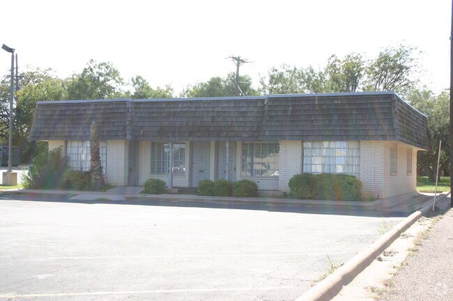
Property Record
222 Westwood Dr, Abilene, TX 79603


NEARBY LISTINGS FOR SALE OR LEASE
Property Detail
222 Westwood Dr
Abilene, TX
Westwood Plaza
30115
WESTWOOD PLAZA, BLOCK 3, LOT 2
Multipleuses
Taylor
AE
Texas
48441C0209F
2
2024
0.35 AC
2025
Westwood Richland
011300
Other Market Areas
1,648 SF
DEMOGRAPHICS near 222 Westwood Dr
1 Mile
3 Mile
5 Mile
2024 Total Population
11,263
68,005
104,299
2029 Population
11,521
70,099
107,318
Pop Growth 2024-2029
+ 2.29%
+ 3.08%
+ 2.89%
Average Age
37
36
36
2024 Total Households
4,326
26,041
40,235
HH Growth 2024-2029
+ 2.57%
+ 3.31%
+ 3.09%
Median Household Inc
$50,514
$46,127
$50,415
Avg Household Size
2.50
2.40
2.40
2024 Avg HH Vehicles
2.00
2.00
2.00
Median Home Value
$137,337
$115,933
$137,226
Median Year Built
1956
1958
1969
Nearby Places
Map Layers
Map Styles
 Street
 Aerial
- Restaurants
- Banks
- Shops
- Fitness
- Groceries
PUBLIC TRANSPORTATION
AIRPORT
Abilene Regional
DRIVE
WALK
Distance
Abilene Regional
15 min
7.7 mi
Freight Ports
Calhoun Port
DRIVE
WALK
Distance
Calhoun Port
438 min
376.8 mi
Nearby Properties
Address
Land Use
TOTAL SIZE
Lot Size
Zoning
Address
Land Use
TOTAL SIZE
Lot Size
Zoning
24.36 AC
Address
Land Use
TOTAL SIZE
Lot Size
Zoning
169,821 SF
3.59 AC
Address
Land Use
TOTAL SIZE
Lot Size
Zoning
600,001 SF
39.40 AC
Address
Land Use
TOTAL SIZE
Lot Size
Zoning
183,321 SF
11.67 AC
Address
Land Use
TOTAL SIZE
Lot Size
Zoning
141,777 SF
36.78 AC
Address
Land Use
TOTAL SIZE
Lot Size
Zoning
129,462 SF
69.58 AC
Address
Land Use
TOTAL SIZE
Lot Size
Zoning
162,480 SF
9.88 AC
Address
Land Use
TOTAL SIZE
Lot Size
Zoning
95,893 SF
15.89 AC
Address
Land Use
TOTAL SIZE
Lot Size
Zoning
144,349 SF
11.07 AC
Address
Land Use
TOTAL SIZE
Lot Size
Zoning
342,750 SF
34.54 AC
Address
Land Use
TOTAL SIZE
Lot Size
Zoning
176,378 SF
36.99 AC
Address
Land Use
TOTAL SIZE
Lot Size
Zoning
73,947 SF
9.89 AC
Address
Land Use
TOTAL SIZE
Lot Size
Zoning
71,515 SF
9.94 AC
Address
Land Use
TOTAL SIZE
Lot Size
Zoning
2.63 AC
Address
Land Use
TOTAL SIZE
Lot Size
Zoning
84,335 SF
4.68 AC
Address
Land Use
TOTAL SIZE
Lot Size
Zoning
52,028 SF
3.62 AC
Address
Land Use
TOTAL SIZE
Lot Size
Zoning
161,050 SF
12.18 AC
Address
Land Use
TOTAL SIZE
Lot Size
Zoning
62,823 SF
9.39 AC
Address
Land Use
TOTAL SIZE
Lot Size
Zoning
155,780 SF
18.80 AC
Address
Land Use
TOTAL SIZE
Lot Size
Zoning
121,816 SF
3.06 AC
Address
Land Use
TOTAL SIZE
Lot Size
Zoning
9.55 AC
Address
Land Use
TOTAL SIZE
Lot Size
Zoning
2.63 AC
Address
Land Use
TOTAL SIZE
Lot Size
Zoning
150,552 SF
9.72 AC
Address
Land Use
TOTAL SIZE
Lot Size
Zoning
42,509 SF
8.63 AC
Address
Land Use
TOTAL SIZE
Lot Size
Zoning
38,150 SF
3.52 AC
Address
Land Use
TOTAL SIZE
Lot Size
Zoning
54,844 SF
12.70 AC
Address
Land Use
TOTAL SIZE
Lot Size
Zoning
140,297 SF
7.99 AC
Address
Land Use
TOTAL SIZE
Lot Size
Zoning
143,931 SF
13.21 AC
Address
Land Use
TOTAL SIZE
Lot Size
Zoning
104,728 SF
17.56 AC
Address
Land Use
TOTAL SIZE
Lot Size
Zoning
473,106 SF
4.68 AC
The World's #1 Commercial Real Estate Marketplace
Connect with us
© 2026 CoStar Group
The information above has been obtained from sources believed reliable. While we do not doubt its accuracy we have not verified it and make no guarantee, warranty or representation about it. It is your responsibility to independently confirm its accuracy and completeness. Any projections, opinions, assumptions, or estimates used are for example only and do not represent the current or future performance of the property. The value of this transaction to you depends on tax and other factors which should be evaluated by your tax, financial, and legal advisors. You and your advisors should conduct a careful, independent investigation of the property to determine to your satisfaction the suitability of the property for your needs.