Property Record
2220 20Th Ave Nw, Altoona, IA 50009

NEARBY LISTINGS FOR SALE OR LEASE
-
-
View all Altoona listings for sale on LoopNet.com
Property Detail
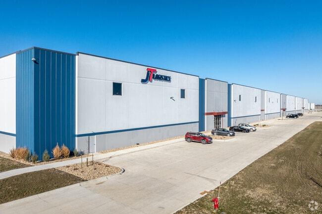
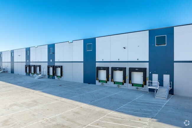
2220 20Th Ave Nw
Des Moines
I-80 Business Park Plat 2
Des Moines-West Des Moines, IA
PRT LOT 1 IN NE 1/4 NE 1/4 SEC 11-79-23 I-80 BUSINESS PARK PLAT 2
171/42311-226-005
Polk
Warehouse
Iowa
0
1
2025
10.08 AC
010702
Northeast
314,940 SF
DEMOGRAPHICS near 2220 20Th Ave Nw
1 Mile
3 Mile
5 Mile
2024 Total Population
2,702
27,273
54,482
2029 Population
3,005
29,008
57,466
Pop Growth 2024-2029
+ 11.21%
+ 6.36%
+ 5.48%
Average Age
36
37
38
2024 Total Households
985
10,122
20,515
HH Growth 2024-2029
+ 11.27%
+ 6.29%
+ 5.39%
Median Household Inc
$95,958
$84,777
$79,368
Avg Household Size
2.70
2.60
2.60
2024 Avg HH Vehicles
2.00
2.00
2.00
Median Home Value
$323,077
$244,674
$234,814
Median Year Built
2008
2000
1996
Nearby Places
Map Layers
Map Styles
 Street
 Aerial
- Restaurants
- Banks
- Shops
- Fitness
- Groceries
PUBLIC TRANSPORTATION
AIRPORT
Des Moines International
DRIVE
WALK
Distance
Des Moines International
35 min
17.4 mi
Freight Ports
Port Milwaukee
DRIVE
WALK
Distance
Port Milwaukee
407 min
365.2 mi
Nearby Properties
Address
Land Use
TOTAL SIZE
Lot Size
Zoning
Address
Land Use
TOTAL SIZE
Lot Size
Zoning
549,615 SF
149.20 AC
C6
Address
Land Use
TOTAL SIZE
Lot Size
Zoning
397,563 SF
18.25 AC
Address
Land Use
TOTAL SIZE
Lot Size
Zoning
325,160 SF
17.24 AC
Address
Land Use
TOTAL SIZE
Lot Size
Zoning
259,056 SF
16.31 AC
Address
Land Use
TOTAL SIZE
Lot Size
Zoning
302,604 SF
16.46 AC
Address
Land Use
TOTAL SIZE
Lot Size
Zoning
142,032 SF
10 AC
Address
Land Use
TOTAL SIZE
Lot Size
Zoning
195,500 SF
15.03 AC
Address
Land Use
TOTAL SIZE
Lot Size
Zoning
195,500 SF
8.09 AC
Address
Land Use
TOTAL SIZE
Lot Size
Zoning
167,308 SF
16.46 AC
Address
Land Use
TOTAL SIZE
Lot Size
Zoning
78,180 SF
7.31 AC
Address
Land Use
TOTAL SIZE
Lot Size
Zoning
135,824 SF
13.22 AC
Address
Land Use
TOTAL SIZE
Lot Size
Zoning
117,924 SF
4.76 AC
R-5
Address
Land Use
TOTAL SIZE
Lot Size
Zoning
49,145 SF
6.06 AC
Address
Land Use
TOTAL SIZE
Lot Size
Zoning
94,445 SF
10.88 AC
M-1
Address
Land Use
TOTAL SIZE
Lot Size
Zoning
134,400 SF
6.01 AC
M-1
Address
Land Use
TOTAL SIZE
Lot Size
Zoning
27,908 SF
14.43 AC
Address
Land Use
TOTAL SIZE
Lot Size
Zoning
96,991 SF
6.47 AC
Address
Land Use
TOTAL SIZE
Lot Size
Zoning
29,000 SF
6.36 AC
M-1
Address
Land Use
TOTAL SIZE
Lot Size
Zoning
34,960 SF
14.09 AC
Address
Land Use
TOTAL SIZE
Lot Size
Zoning
60,321 SF
3.29 AC
C-2
Address
Land Use
TOTAL SIZE
Lot Size
Zoning
5,402 SF
15.09 AC
Address
Land Use
TOTAL SIZE
Lot Size
Zoning
79,410 SF
4.31 AC
R-3
Address
Land Use
TOTAL SIZE
Lot Size
Zoning
51,350 SF
5.28 AC
C-4
Address
Land Use
TOTAL SIZE
Lot Size
Zoning
48,332 SF
1.61 AC
Address
Land Use
TOTAL SIZE
Lot Size
Zoning
34,122 SF
8.08 AC
M-1
Address
Land Use
TOTAL SIZE
Lot Size
Zoning
61,488 SF
3.66 AC
R-3
Address
Land Use
TOTAL SIZE
Lot Size
Zoning
58,443 SF
3.16 AC
C-2
Address
Land Use
TOTAL SIZE
Lot Size
Zoning
61,488 SF
4 AC
R-3
Address
Land Use
TOTAL SIZE
Lot Size
Zoning
61,770 SF
3.74 AC
R-5
The World's #1 Commercial Real Estate Marketplace
Connect with us
© 2026 CoStar Group
The information above has been obtained from sources believed reliable. While we do not doubt its accuracy we have not verified it and make no guarantee, warranty or representation about it. It is your responsibility to independently confirm its accuracy and completeness. Any projections, opinions, assumptions, or estimates used are for example only and do not represent the current or future performance of the property. The value of this transaction to you depends on tax and other factors which should be evaluated by your tax, financial, and legal advisors. You and your advisors should conduct a careful, independent investigation of the property to determine to your satisfaction the suitability of the property for your needs.