Property Record
2220 E 93Rd St, Cleveland, OH 44106

NEARBY LISTINGS FOR SALE OR LEASE
-
-
View all Cleveland listings for sale on LoopNet.com
Property Detail
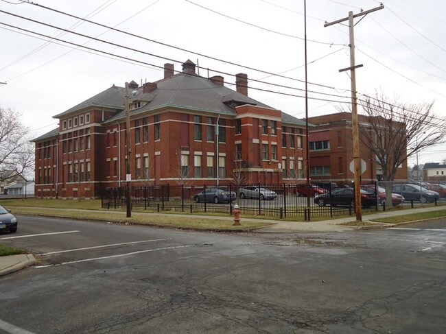
2220 E 93Rd St
Cleveland-Elyria, OH
Denison
005-25-038
13 DENISON S/L146TO 154 ALL 145&155 NP VAC ALLEY S OF WILLARD
Officebuilding
Cuyahoga
X
Ohio
39035C0176F
13
0
1.16 AC
2024
West
101700
Cleveland
66,670 SF
DEMOGRAPHICS near 2220 E 93Rd St
1 Mile
3 Mile
5 Mile
2024 Total Population
25,137
149,030
287,991
2029 Population
24,288
144,333
279,791
Pop Growth 2024-2029
(3.38%)
(3.15%)
(2.85%)
Average Age
36
38
39
2024 Total Households
10,240
68,688
133,298
HH Growth 2024-2029
(3.43%)
(3.17%)
(2.80%)
Median Household Inc
$31,553
$43,623
$49,628
Avg Household Size
2.30
2.10
2.00
2024 Avg HH Vehicles
1.00
1.00
1.00
Median Home Value
$82,313
$128,442
$142,427
Median Year Built
1946
1947
1948
Nearby Places
Map Layers
Map Styles
 Street
 Aerial
- Restaurants
- Banks
- Shops
- Fitness
- Groceries
PUBLIC TRANSPORTATION
TRANSIT/SUBWAY
West Boulevard - Cudell (Red Line - Greater Cleveland Regional Transit Authority Rapid Transit (The Rapid))
DRIVE
WALK
Distance
West Boulevard - Cudell (Red Line - Greater Cleveland Regional Transit Authority Rapid Transit (The Rapid))
4 min
18 min
0.9 mi
COMMUTER RAIL
Cleveland Lakefront Station (Blue Line - Greater Cleveland Regional Transit Authority Rapid Transit (The Rapid), Green Line - Greater Cleveland Regional Transit Authority Rapid Transit (The Rapid))
DRIVE
WALK
Distance
Cleveland Lakefront Station (Blue Line - Greater Cleveland Regional Transit Authority Rapid Transit (The Rapid), Green Line - Greater Cleveland Regional Transit Authority Rapid Transit (The Rapid))
15 min
5.4 mi
AIRPORT
Cleveland-Hopkins International
DRIVE
WALK
Distance
Cleveland-Hopkins International
20 min
8.7 mi
Nearby Properties
Address
Land Use
TOTAL SIZE
Lot Size
Zoning
Address
Land Use
TOTAL SIZE
Lot Size
Zoning
3,491,901 SF
34.32 AC
Address
Land Use
TOTAL SIZE
Lot Size
Zoning
5,100 SF
9.41 AC
GI
Address
Land Use
TOTAL SIZE
Lot Size
Zoning
3.23 AC
LLR
Address
Land Use
TOTAL SIZE
Lot Size
Zoning
70.02 AC
GI
Address
Land Use
TOTAL SIZE
Lot Size
Zoning
257,857 SF
8.03 AC
GR
Address
Land Use
TOTAL SIZE
Lot Size
Zoning
299,507 SF
2.14 AC
LR
Address
Land Use
TOTAL SIZE
Lot Size
Zoning
2.83 AC
LLR
Address
Land Use
TOTAL SIZE
Lot Size
Zoning
518,244 SF
21.80 AC
Address
Land Use
TOTAL SIZE
Lot Size
Zoning
300,000 SF
2.07 AC
Address
Land Use
TOTAL SIZE
Lot Size
Zoning
208,209 SF
12.10 AC
1F
Address
Land Use
TOTAL SIZE
Lot Size
Zoning
164,294 SF
13.81 AC
GI
Address
Land Use
TOTAL SIZE
Lot Size
Zoning
320,334 SF
4 AC
GR
Address
Land Use
TOTAL SIZE
Lot Size
Zoning
200,874 SF
3.30 AC
LR
Address
Land Use
TOTAL SIZE
Lot Size
Zoning
227,787 SF
3.40 AC
LR
Address
Land Use
TOTAL SIZE
Lot Size
Zoning
242,515 SF
1.01 AC
Address
Land Use
TOTAL SIZE
Lot Size
Zoning
340,593 SF
10.10 AC
G-1
Address
Land Use
TOTAL SIZE
Lot Size
Zoning
308,339 SF
9.78 AC
2F
Address
Land Use
TOTAL SIZE
Lot Size
Zoning
168,750 SF
18.55 AC
GI
Address
Land Use
TOTAL SIZE
Lot Size
Zoning
123,130 SF
21.88 AC
GI
Address
Land Use
TOTAL SIZE
Lot Size
Zoning
28,852 SF
8.17 AC
Address
Land Use
TOTAL SIZE
Lot Size
Zoning
3.96 AC
Address
Land Use
TOTAL SIZE
Lot Size
Zoning
361,287 SF
86.50 AC
2F
Address
Land Use
TOTAL SIZE
Lot Size
Zoning
258,852 SF
5.20 AC
MF2
Address
Land Use
TOTAL SIZE
Lot Size
Zoning
142,935 SF
1.02 AC
LR
Address
Land Use
TOTAL SIZE
Lot Size
Zoning
22,928 SF
2.17 AC
LR
Address
Land Use
TOTAL SIZE
Lot Size
Zoning
104,170 SF
2.70 AC
2F
Address
Land Use
TOTAL SIZE
Lot Size
Zoning
389,067 SF
12.05 AC
A-H
Address
Land Use
TOTAL SIZE
Lot Size
Zoning
372,786 SF
4.79 AC
MF3+
Address
Land Use
TOTAL SIZE
Lot Size
Zoning
145,936 SF
1.05 AC
2F
Address
Land Use
TOTAL SIZE
Lot Size
Zoning
155,896 SF
5.03 AC
The World's #1 Commercial Real Estate Marketplace
Connect with us
© 2026 CoStar Group
The information above has been obtained from sources believed reliable. While we do not doubt its accuracy we have not verified it and make no guarantee, warranty or representation about it. It is your responsibility to independently confirm its accuracy and completeness. Any projections, opinions, assumptions, or estimates used are for example only and do not represent the current or future performance of the property. The value of this transaction to you depends on tax and other factors which should be evaluated by your tax, financial, and legal advisors. You and your advisors should conduct a careful, independent investigation of the property to determine to your satisfaction the suitability of the property for your needs.