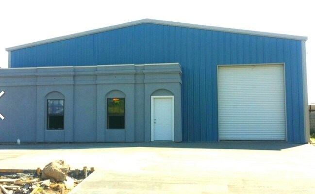
Property Record
2220 Houston St, Laredo, TX 78040

NEARBY LISTINGS FOR SALE OR LEASE
Property Detail
2220 Houston St
162463
Western -- Blocks 351 - 400
Commercialnec
ALL OF BLK 377 WD
X
Webb
48479C1195C
Texas
2024
1
2025
1.23 AC
000800
Other Market Areas
17,258 SF
Laredo, TX
DEMOGRAPHICS near 2220 Houston St
1 Mile
3 Mile
5 Mile
2024 Total Population
8,226
61,485
145,288
2029 Population
8,270
61,621
145,943
Pop Growth 2024-2029
+ 0.53%
+ 0.22%
+ 0.45%
Average Age
38
36
35
2024 Total Households
2,715
19,805
44,214
HH Growth 2024-2029
+ 0.66%
+ 0.26%
+ 0.50%
Median Household Inc
$21,236
$32,488
$41,180
Avg Household Size
2.90
3.00
3.20
2024 Avg HH Vehicles
1.00
2.00
2.00
Median Home Value
$72,396
$97,879
$131,696
Median Year Built
1962
1973
1986
Nearby Places
Map Layers
Map Styles
 Street
 Aerial
- Restaurants
- Banks
- Shops
- Fitness
- Groceries
PUBLIC TRANSPORTATION
AIRPORT
Laredo International
DRIVE
WALK
Distance
Laredo International
16 min
7.5 mi
Freight Ports
Port of Corpus Christi
DRIVE
WALK
Distance
Port of Corpus Christi
168 min
144.0 mi
SALE & LEASE HISTORY
LISTING DATE
SALE/LEASE

Sep 25, 2016
For Lease
Nearby Properties
Address
Land Use
TOTAL SIZE
Lot Size
Zoning
Address
Land Use
TOTAL SIZE
Lot Size
Zoning
1,019,636 SF
202.89 AC
B3
Address
Land Use
TOTAL SIZE
Lot Size
Zoning
668,900 SF
38.32 AC
B4
Address
Land Use
TOTAL SIZE
Lot Size
Zoning
497,463 SF
1.77 AC
R1
Address
Land Use
TOTAL SIZE
Lot Size
Zoning
224,926 SF
21.49 AC
R3
Address
Land Use
TOTAL SIZE
Lot Size
Zoning
689,547 SF
2.70 AC
B3
Address
Land Use
TOTAL SIZE
Lot Size
Zoning
144,491 SF
3.54 AC
CBD
Address
Land Use
TOTAL SIZE
Lot Size
Zoning
96,991 SF
1.59 AC
CBD
Address
Land Use
TOTAL SIZE
Lot Size
Zoning
192,176 SF
34.94 AC
Address
Land Use
TOTAL SIZE
Lot Size
Zoning
127,364 SF
1.60 AC
CBD
Address
Land Use
TOTAL SIZE
Lot Size
Zoning
157,376 SF
25.86 AC
B3
Address
Land Use
TOTAL SIZE
Lot Size
Zoning
25,104 SF
1.42 AC
CBD
Address
Land Use
TOTAL SIZE
Lot Size
Zoning
139,521 SF
18.13 AC
M1
Address
Land Use
TOTAL SIZE
Lot Size
Zoning
101,734 SF
1.63 AC
B3
Address
Land Use
TOTAL SIZE
Lot Size
Zoning
113,687 SF
5.58 AC
R3
Address
Land Use
TOTAL SIZE
Lot Size
Zoning
93,414 SF
8.57 AC
R1
Address
Land Use
TOTAL SIZE
Lot Size
Zoning
98,005 SF
0.67 AC
B3
Address
Land Use
TOTAL SIZE
Lot Size
Zoning
70,980 SF
1.44 AC
CBD
Address
Land Use
TOTAL SIZE
Lot Size
Zoning
97,580 SF
3.89 AC
B1
Address
Land Use
TOTAL SIZE
Lot Size
Zoning
94,056 SF
1.77 AC
Address
Land Use
TOTAL SIZE
Lot Size
Zoning
92,559 SF
5.70 AC
R1
Address
Land Use
TOTAL SIZE
Lot Size
Zoning
98,475 SF
1.59 AC
R3
Address
Land Use
TOTAL SIZE
Lot Size
Zoning
82,328 SF
5.12 AC
R3
Address
Land Use
TOTAL SIZE
Lot Size
Zoning
79,772 SF
1.77 AC
R3
Address
Land Use
TOTAL SIZE
Lot Size
Zoning
78,968 SF
3.51 AC
B1
Address
Land Use
TOTAL SIZE
Lot Size
Zoning
76,753 SF
0.89 AC
R3
Address
Land Use
TOTAL SIZE
Lot Size
Zoning
72,563 SF
2.13 AC
R1
Address
Land Use
TOTAL SIZE
Lot Size
Zoning
124,530 SF
8.19 AC
B4
Address
Land Use
TOTAL SIZE
Lot Size
Zoning
78,275 SF
3.36 AC
R3
Address
Land Use
TOTAL SIZE
Lot Size
Zoning
48,228 SF
1.41 AC
CBD
Address
Land Use
TOTAL SIZE
Lot Size
Zoning
140,295 SF
16.74 AC
B4
The World's #1 Commercial Real Estate Marketplace
Connect with us
© 2026 CoStar Group
The information above has been obtained from sources believed reliable. While we do not doubt its accuracy we have not verified it and make no guarantee, warranty or representation about it. It is your responsibility to independently confirm its accuracy and completeness. Any projections, opinions, assumptions, or estimates used are for example only and do not represent the current or future performance of the property. The value of this transaction to you depends on tax and other factors which should be evaluated by your tax, financial, and legal advisors. You and your advisors should conduct a careful, independent investigation of the property to determine to your satisfaction the suitability of the property for your needs.