Property Record
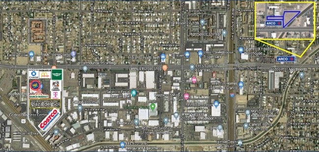
2220 W Indian School Rd, Phoenix, AZ 85015
This Property Is For Sale
NEARBY LISTINGS FOR SALE OR LEASE
-
-
-
-
No Photo
-
-
-
-
-
-
-
-
-
-
-
-
-
-
-
-
View all Phoenix listings for sale on LoopNet.com
Property Detail
2220 W Indian School Rd
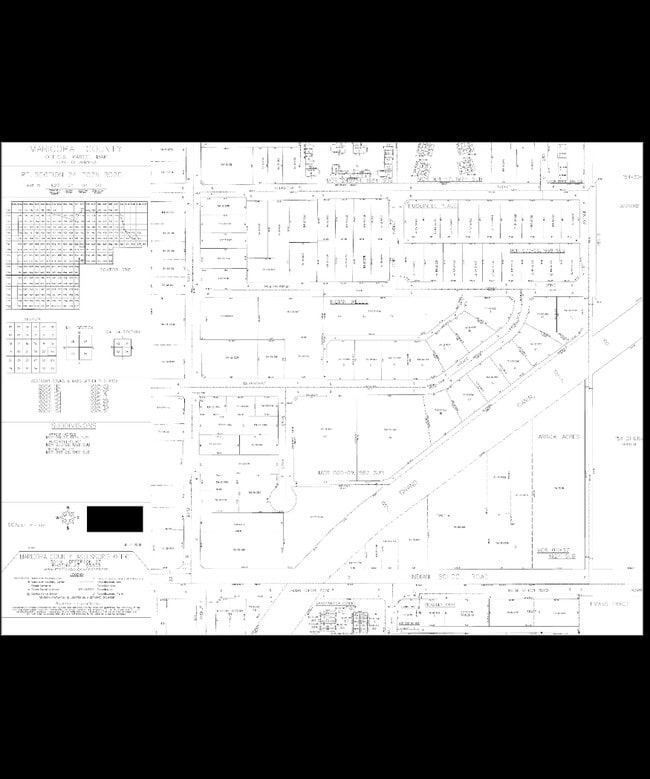
154-29-006A
THAT PT SW4 SE4 BEG 33F N & S 89D 39M E 258F FR S 4 COR SEC TH N PAR TO CEN LI SEC 24 299.22F TH S 89D 47M E 346.64F TO PT ON NWLY R/W OF GR CAN TH S 52D 56M W 109.83F TH S 48D 53M W 125.64F TH S 4 4D 00M W 206.39F TO PT OF INTERSECT SEC OF SD NWL Y
Commercialnec
Maricopa
A
Arizona
04013C2205L
1.06 AC
2025
Northwest Phoenix
2025
Phoenix
109002
Phoenix-Mesa-Scottsdale, AZ
DEMOGRAPHICS near 2220 W Indian School Rd
1 Mile
3 Mile
5 Mile
2024 Total Population
29,580
184,292
485,171
2029 Population
31,881
198,932
524,638
Pop Growth 2024-2029
+ 7.78%
+ 7.94%
+ 8.13%
Average Age
33
35
35
2024 Total Households
10,288
67,389
178,867
HH Growth 2024-2029
+ 7.81%
+ 8.53%
+ 8.64%
Median Household Inc
$44,721
$53,655
$53,822
Avg Household Size
2.80
2.50
2.50
2024 Avg HH Vehicles
1.00
2.00
2.00
Median Home Value
$284,871
$326,705
$323,029
Median Year Built
1970
1968
1970
Nearby Places
- Restaurants
- Banks
- Shops
- Fitness
- Groceries
PUBLIC TRANSPORTATION
AIRPORT
Phoenix Sky Harbor International
DRIVE
WALK
Distance
Phoenix Sky Harbor International
17 min
10.9 mi
Phoenix-Mesa Gateway
DRIVE
WALK
Distance
Phoenix-Mesa Gateway
50 min
37.7 mi
Freight Ports
Port of San Diego
DRIVE
WALK
Distance
Port of San Diego
396 min
355.2 mi
Nearby Properties
Address
Land Use
TOTAL SIZE
Lot Size
Zoning
Address
Land Use
TOTAL SIZE
Lot Size
Zoning
582,073 SF
1.45 AC
C-C
Address
Land Use
TOTAL SIZE
Lot Size
Zoning
1.85 AC
Address
Land Use
TOTAL SIZE
Lot Size
Zoning
455,443 SF
3.21 AC
C-C
Address
Land Use
TOTAL SIZE
Lot Size
Zoning
339,909 SF
3 AC
C-C
Address
Land Use
TOTAL SIZE
Lot Size
Zoning
437,102 SF
1.02 AC
C-2
Address
Land Use
TOTAL SIZE
Lot Size
Zoning
2,334,671 SF
32.63 AC
C-2
Address
Land Use
TOTAL SIZE
Lot Size
Zoning
191,120 SF
1.43 AC
C-C
Address
Land Use
TOTAL SIZE
Lot Size
Zoning
96,183 SF
11.04 AC
R-6
Address
Land Use
TOTAL SIZE
Lot Size
Zoning
913,637 SF
35.53 AC
M-H
Address
Land Use
TOTAL SIZE
Lot Size
Zoning
686,094 SF
5.09 AC
C-C
Address
Land Use
TOTAL SIZE
Lot Size
Zoning
69,542 SF
4.92 AC
I-P
Address
Land Use
TOTAL SIZE
Lot Size
Zoning
860,020 SF
5.89 AC
C2
Address
Land Use
TOTAL SIZE
Lot Size
Zoning
377,037 SF
35.46 AC
R1-6
Address
Land Use
TOTAL SIZE
Lot Size
Zoning
21,587 SF
3.66 AC
R-10
Address
Land Use
TOTAL SIZE
Lot Size
Zoning
956,022 SF
14.86 AC
Address
Land Use
TOTAL SIZE
Lot Size
Zoning
547,141 SF
18.52 AC
R-6
Address
Land Use
TOTAL SIZE
Lot Size
Zoning
184,363 SF
1.24 AC
WU
Address
Land Use
TOTAL SIZE
Lot Size
Zoning
496,222 SF
29.53 AC
C-R
Address
Land Use
TOTAL SIZE
Lot Size
Zoning
729,101 SF
4.31 AC
C-2
Address
Land Use
TOTAL SIZE
Lot Size
Zoning
42,631 SF
2.90 AC
A-2
Address
Land Use
TOTAL SIZE
Lot Size
Zoning
329,830 SF
12.18 AC
Address
Land Use
TOTAL SIZE
Lot Size
Zoning
32,600 SF
2.38 AC
R-5
Address
Land Use
TOTAL SIZE
Lot Size
Zoning
337,487 SF
39 AC
R-6
Address
Land Use
TOTAL SIZE
Lot Size
Zoning
423,681 SF
8.29 AC
Address
Land Use
TOTAL SIZE
Lot Size
Zoning
458,432 SF
3.80 AC
C-DT
Address
Land Use
TOTAL SIZE
Lot Size
Zoning
474,952 SF
13.68 AC
C-C
Address
Land Use
TOTAL SIZE
Lot Size
Zoning
1,175,686 SF
4.28 AC
C-C
Address
Land Use
TOTAL SIZE
Lot Size
Zoning
539,614 SF
2.03 AC
C-N
Address
Land Use
TOTAL SIZE
Lot Size
Zoning
560,729 SF
5.57 AC
DTCGTWY
Address
Land Use
TOTAL SIZE
Lot Size
Zoning
378,071 SF
1.52 AC
C-C
The World's #1 Commercial Real Estate Marketplace
Connect with us
© 2025 CoStar Group
The information above has been obtained from sources believed reliable. While we do not doubt its accuracy we have not verified it and make no guarantee, warranty or representation about it. It is your responsibility to independently confirm its accuracy and completeness. Any projections, opinions, assumptions, or estimates used are for example only and do not represent the current or future performance of the property. The value of this transaction to you depends on tax and other factors which should be evaluated by your tax, financial, and legal advisors. You and your advisors should conduct a careful, independent investigation of the property to determine to your satisfaction the suitability of the property for your needs.