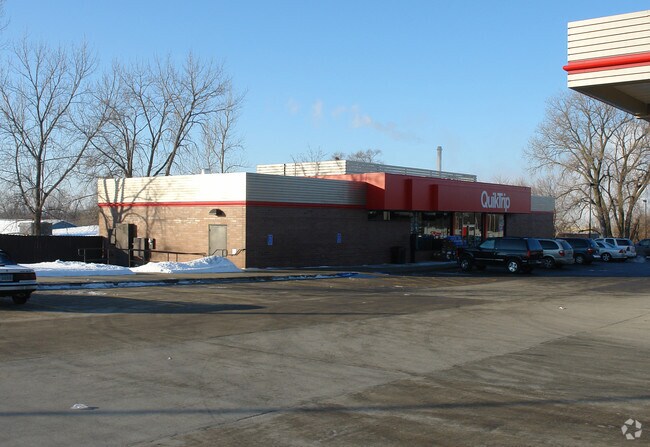
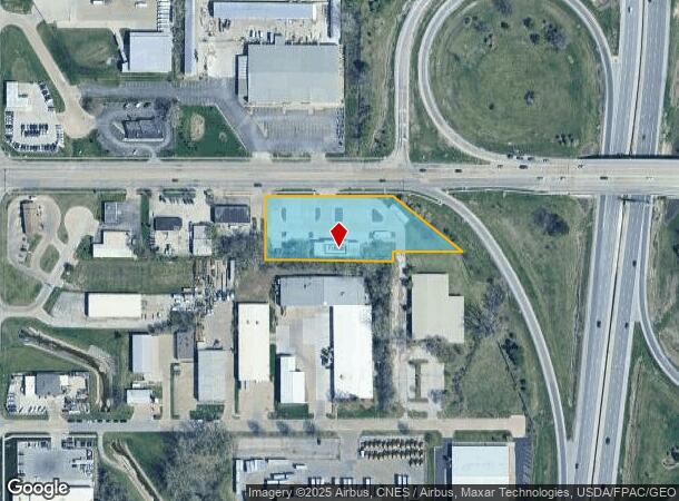
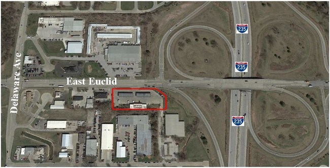
Property Record
2221 E Euclid Ave, Des Moines, IA 50317
NEARBY LISTINGS FOR SALE OR LEASE
Property Detail
2221 E Euclid Ave
Des Moines-West Des Moines, IA
Ovid Heights
060-07595009004
E 91F LT 8 & ALL LT 9 & SW OF LN BEG 185F E OF SW COR ON S LN THN NWLY TO NW COR LT 10 OVID HEIGHTS
Storebuilding
Polk
X
Iowa
19153C0215F
8
2024
1.62 AC
2025
Northeast
000300
Des Moines
4,356 SF
DEMOGRAPHICS near 2221 E Euclid Ave
1 Mile
3 Mile
5 Mile
2024 Total Population
6,055
65,577
152,507
2029 Population
6,256
68,062
159,252
Pop Growth 2024-2029
+ 3.32%
+ 3.79%
+ 4.42%
Average Age
40
38
37
2024 Total Households
2,392
25,023
62,039
HH Growth 2024-2029
+ 3.55%
+ 4.01%
+ 4.70%
Median Household Inc
$63,034
$53,867
$56,213
Avg Household Size
2.30
2.40
2.30
2024 Avg HH Vehicles
2.00
2.00
2.00
Median Home Value
$153,667
$134,555
$157,430
Median Year Built
1959
1954
1964
Nearby Places
Map Layers
Map Styles
 Street
 Aerial
- Restaurants
- Banks
- Shops
- Fitness
- Groceries
PUBLIC TRANSPORTATION
AIRPORT
Des Moines International
DRIVE
WALK
Distance
Des Moines International
22 min
10.9 mi
SALE & LEASE HISTORY
LISTING DATE
SALE/LEASE

Oct 04, 2019
For Sale
Nearby Properties
Address
Land Use
TOTAL SIZE
Lot Size
Zoning
Address
Land Use
TOTAL SIZE
Lot Size
Zoning
428,582 SF
6.87 AC
C-0
Address
Land Use
TOTAL SIZE
Lot Size
Zoning
481,030 SF
31.92 AC
PUD
Address
Land Use
TOTAL SIZE
Lot Size
Zoning
675,000 SF
65.27 AC
Address
Land Use
TOTAL SIZE
Lot Size
Zoning
600,000 SF
40.15 AC
Address
Land Use
TOTAL SIZE
Lot Size
Zoning
177,094 SF
24.60 AC
Address
Land Use
TOTAL SIZE
Lot Size
Zoning
402,849 SF
0.83 AC
C-3
Address
Land Use
TOTAL SIZE
Lot Size
Zoning
312,500 SF
38.14 AC
Address
Land Use
TOTAL SIZE
Lot Size
Zoning
320,429 SF
22.34 AC
R3
Address
Land Use
TOTAL SIZE
Lot Size
Zoning
529,161 SF
33.60 AC
HI
Address
Land Use
TOTAL SIZE
Lot Size
Zoning
126,935 SF
28.61 AC
Address
Land Use
TOTAL SIZE
Lot Size
Zoning
130,496 SF
39.96 AC
HI
Address
Land Use
TOTAL SIZE
Lot Size
Zoning
275,000 SF
16.17 AC
HI
Address
Land Use
TOTAL SIZE
Lot Size
Zoning
603,502 SF
33.03 AC
M-1
Address
Land Use
TOTAL SIZE
Lot Size
Zoning
1,838,971 SF
76.24 AC
HI
Address
Land Use
TOTAL SIZE
Lot Size
Zoning
90,325 SF
5.49 AC
PUD
Address
Land Use
TOTAL SIZE
Lot Size
Zoning
82,202 SF
9.48 AC
PUD
Address
Land Use
TOTAL SIZE
Lot Size
Zoning
170,872 SF
25 AC
Address
Land Use
TOTAL SIZE
Lot Size
Zoning
184,320 SF
9.68 AC
Address
Land Use
TOTAL SIZE
Lot Size
Zoning
162,240 SF
9.19 AC
Address
Land Use
TOTAL SIZE
Lot Size
Zoning
79,991 SF
4.55 AC
M-1
Address
Land Use
TOTAL SIZE
Lot Size
Zoning
1,890,511 SF
39.03 AC
M-2
Address
Land Use
TOTAL SIZE
Lot Size
Zoning
274,160 SF
19.99 AC
M-1
Address
Land Use
TOTAL SIZE
Lot Size
Zoning
181,492 SF
12.32 AC
M1
Address
Land Use
TOTAL SIZE
Lot Size
Zoning
79,823 SF
11.47 AC
M2
Address
Land Use
TOTAL SIZE
Lot Size
Zoning
198,500 SF
11.79 AC
M-1
Address
Land Use
TOTAL SIZE
Lot Size
Zoning
71,666 SF
18.40 AC
R1-80
Address
Land Use
TOTAL SIZE
Lot Size
Zoning
199,180 SF
9.64 AC
M-1
Address
Land Use
TOTAL SIZE
Lot Size
Zoning
83,885 SF
1.57 AC
PUD
Address
Land Use
TOTAL SIZE
Lot Size
Zoning
174,600 SF
1.21 AC
C-2
Address
Land Use
TOTAL SIZE
Lot Size
Zoning
548,576 SF
19.48 AC
LI
The World's #1 Commercial Real Estate Marketplace
Connect with us
© 2025 CoStar Group
The information above has been obtained from sources believed reliable. While we do not doubt its accuracy we have not verified it and make no guarantee, warranty or representation about it. It is your responsibility to independently confirm its accuracy and completeness. Any projections, opinions, assumptions, or estimates used are for example only and do not represent the current or future performance of the property. The value of this transaction to you depends on tax and other factors which should be evaluated by your tax, financial, and legal advisors. You and your advisors should conduct a careful, independent investigation of the property to determine to your satisfaction the suitability of the property for your needs.