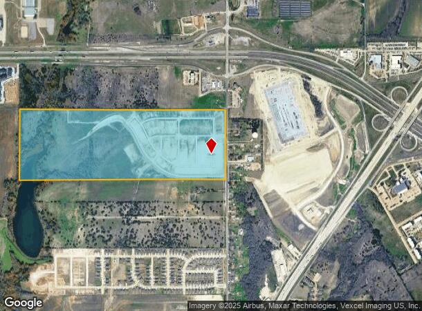
Property Record
2221 Ovilla Rd, Waxahachie, TX 75167

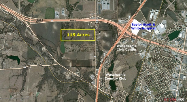
NEARBY LISTINGS FOR SALE OR LEASE
Property Detail
2221 Ovilla Rd
Dallas-Fort Worth-Arlington, TX
Wm C Tunnell
191627
1080 WM C TUNNELL 68.856 ACRES
Agriculturalland
Ellis
A
Texas
48139C0190G
2
2024
68.86 AC
2025
Ellis County
061100
Dallas/Ft Worth
DEMOGRAPHICS near 2221 Ovilla Rd
1 Mile
3 Mile
5 Mile
2024 Total Population
2,125
14,490
62,475
2029 Population
2,675
18,256
78,972
Pop Growth 2024-2029
+ 25.88%
+ 25.99%
+ 26.41%
Average Age
39
38
38
2024 Total Households
688
4,662
21,213
HH Growth 2024-2029
+ 26.31%
+ 26.32%
+ 26.64%
Median Household Inc
$124,608
$125,089
$109,104
Avg Household Size
3.10
3.10
2.90
2024 Avg HH Vehicles
3.00
3.00
2.00
Median Home Value
$367,770
$354,850
$307,017
Median Year Built
2004
2005
2004
Nearby Places
Map Layers
Map Styles
 Street
 Aerial
- Restaurants
- Banks
- Shops
- Fitness
- Groceries
PUBLIC TRANSPORTATION
AIRPORT
Dallas Love Field
DRIVE
WALK
Distance
Dallas Love Field
44 min
32.6 mi
Freight Ports
Port of Shreveport
DRIVE
WALK
Distance
Port of Shreveport
230 min
213.8 mi
SALE & LEASE HISTORY
LISTING DATE
SALE/LEASE

May 06, 2019
For Sale
Mar 27, 2017
For Sale
Nearby Properties
Address
Land Use
TOTAL SIZE
Lot Size
Zoning
Address
Land Use
TOTAL SIZE
Lot Size
Zoning
488,705 SF
43.76 AC
Address
Land Use
TOTAL SIZE
Lot Size
Zoning
413,618 SF
94.72 AC
Address
Land Use
TOTAL SIZE
Lot Size
Zoning
630,460 SF
71.82 AC
Address
Land Use
TOTAL SIZE
Lot Size
Zoning
643,064 SF
42.15 AC
Address
Land Use
TOTAL SIZE
Lot Size
Zoning
408,068 SF
7.42 AC
Address
Land Use
TOTAL SIZE
Lot Size
Zoning
259,166 SF
11.07 AC
Address
Land Use
TOTAL SIZE
Lot Size
Zoning
675,375 SF
59.26 AC
Address
Land Use
TOTAL SIZE
Lot Size
Zoning
193,837 SF
10.41 AC
Address
Land Use
TOTAL SIZE
Lot Size
Zoning
99,354 SF
62.87 AC
Address
Land Use
TOTAL SIZE
Lot Size
Zoning
258,147 SF
12.40 AC
Address
Land Use
TOTAL SIZE
Lot Size
Zoning
177,000 SF
20.25 AC
Address
Land Use
TOTAL SIZE
Lot Size
Zoning
708,800 SF
149.18 AC
Address
Land Use
TOTAL SIZE
Lot Size
Zoning
198,180 SF
11.48 AC
Address
Land Use
TOTAL SIZE
Lot Size
Zoning
1,123,347 SF
74.97 AC
Address
Land Use
TOTAL SIZE
Lot Size
Zoning
413,050 SF
54.30 AC
Address
Land Use
TOTAL SIZE
Lot Size
Zoning
134,530 SF
12.11 AC
Address
Land Use
TOTAL SIZE
Lot Size
Zoning
178,880 SF
5.51 AC
Address
Land Use
TOTAL SIZE
Lot Size
Zoning
150,886 SF
11.02 AC
Address
Land Use
TOTAL SIZE
Lot Size
Zoning
85,823 SF
56.24 AC
Address
Land Use
TOTAL SIZE
Lot Size
Zoning
118,782 SF
5.11 AC
Address
Land Use
TOTAL SIZE
Lot Size
Zoning
326,740 SF
23.01 AC
Address
Land Use
TOTAL SIZE
Lot Size
Zoning
352,350 SF
18.78 AC
Address
Land Use
TOTAL SIZE
Lot Size
Zoning
568,234 SF
65.79 AC
Address
Land Use
TOTAL SIZE
Lot Size
Zoning
886,858 SF
8.60 AC
Address
Land Use
TOTAL SIZE
Lot Size
Zoning
109,978 SF
28.14 AC
Address
Land Use
TOTAL SIZE
Lot Size
Zoning
278,000 SF
22.82 AC
Address
Land Use
TOTAL SIZE
Lot Size
Zoning
92,475 SF
12.38 AC
Address
Land Use
TOTAL SIZE
Lot Size
Zoning
326,130 SF
18.48 AC
Address
Land Use
TOTAL SIZE
Lot Size
Zoning
115,544 SF
6.70 AC
Address
Land Use
TOTAL SIZE
Lot Size
Zoning
120,587 SF
23.95 AC
The World's #1 Commercial Real Estate Marketplace
Connect with us
© 2025 CoStar Group
The information above has been obtained from sources believed reliable. While we do not doubt its accuracy we have not verified it and make no guarantee, warranty or representation about it. It is your responsibility to independently confirm its accuracy and completeness. Any projections, opinions, assumptions, or estimates used are for example only and do not represent the current or future performance of the property. The value of this transaction to you depends on tax and other factors which should be evaluated by your tax, financial, and legal advisors. You and your advisors should conduct a careful, independent investigation of the property to determine to your satisfaction the suitability of the property for your needs.