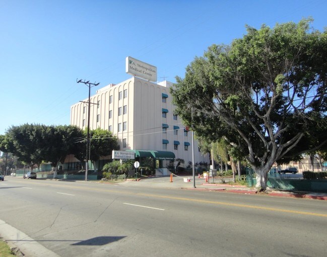
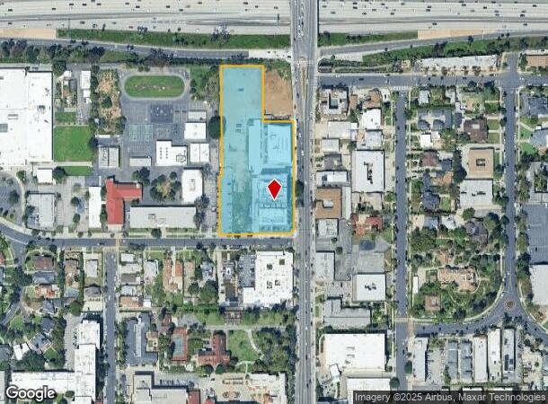
Property Record
2231 S Western Ave, Los Angeles, CA 90018
NEARBY LISTINGS FOR SALE OR LEASE
Property Detail
2231 S Western Ave
Los Angeles-Long Beach-Glendale, CA
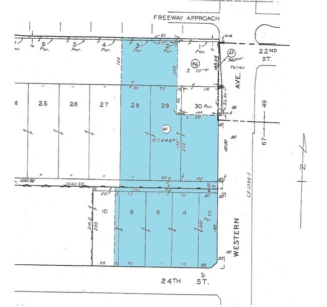
LAND DESC IN DOC471148, 20210712 M M B 8-61 AND M R 66-88
5058-009-051
Los Angeles
Retailwithmorethanonenonretailuse
California
2024
3.16 AC
2025
Koreatown
221401
Los Angeles
67,321 SF
DEMOGRAPHICS near 2231 S Western Ave
1 Mile
3 Mile
5 Mile
2024 Total Population
55,547
575,378
1,268,851
2029 Population
53,220
560,112
1,233,251
Pop Growth 2024-2029
(4.19%)
(2.65%)
(2.81%)
Average Age
39
38
38
2024 Total Households
17,787
214,308
486,668
HH Growth 2024-2029
(4.46%)
(2.52%)
(2.68%)
Median Household Inc
$47,755
$49,812
$57,149
Avg Household Size
2.90
2.50
2.40
2024 Avg HH Vehicles
2.00
1.00
1.00
Median Home Value
$819,573
$828,967
$863,590
Median Year Built
1948
1958
1957
Nearby Places
- Restaurants
- Banks
- Shops
- Fitness
- Groceries
PUBLIC TRANSPORTATION
COMMUTER RAIL
Los Angeles (Coast Starlight - Amtrak, Pacific Surfliner - Amtrak, Southwest Chief - Amtrak, Texas Eagle - Amtrak)
DRIVE
WALK
Distance
Los Angeles (Coast Starlight - Amtrak, Pacific Surfliner - Amtrak, Southwest Chief - Amtrak, Texas Eagle - Amtrak)
9 min
5.2 mi
Union Station (91 Line - Southern California Regional Rail Authority (Metrolink), Antelope Valley Line - Southern California Regional Rail Authority (Metrolink), Orange County Line - Southern California Regional Rail Authority (Metrolink), Riverside Line - Southern California Regional Rail Authority (Metrolink), San Bernardino Line - Southern California Regional Rail Authority (Metrolink), Ventura County Line - Southern California Regional Rail Authority (Metrolink))
DRIVE
WALK
Distance
Union Station (91 Line - Southern California Regional Rail Authority (Metrolink), Antelope Valley Line - Southern California Regional Rail Authority (Metrolink), Orange County Line - Southern California Regional Rail Authority (Metrolink), Riverside Line - Southern California Regional Rail Authority (Metrolink), San Bernardino Line - Southern California Regional Rail Authority (Metrolink), Ventura County Line - Southern California Regional Rail Authority (Metrolink))
11 min
5.5 mi
AIRPORT
Los Angeles International
DRIVE
WALK
Distance
Los Angeles International
20 min
11.4 mi
Bob Hope
DRIVE
WALK
Distance
Bob Hope
24 min
13.8 mi
Long Beach (Daugherty Field)
DRIVE
WALK
Distance
Long Beach (Daugherty Field)
31 min
23.3 mi
Freight Ports
Port of Long Beach
DRIVE
WALK
Distance
Port of Long Beach
33 min
25.2 mi
Nearby Properties
Address
Land Use
TOTAL SIZE
Lot Size
Zoning
Address
Land Use
TOTAL SIZE
Lot Size
Zoning
969,516 SF
14.75 AC
Address
Land Use
TOTAL SIZE
Lot Size
Zoning
108,464 SF
9.17 AC
LALASED
Address
Land Use
TOTAL SIZE
Lot Size
Zoning
969,264 SF
0.94 AC
LAC2
Address
Land Use
TOTAL SIZE
Lot Size
Zoning
200,811 SF
4.59 AC
LALASED
Address
Land Use
TOTAL SIZE
Lot Size
Zoning
1,178,786 SF
3.89 AC
LAC2
Address
Land Use
TOTAL SIZE
Lot Size
Zoning
764,804 SF
1.48 AC
Address
Land Use
TOTAL SIZE
Lot Size
Zoning
1,094,768 SF
0.73 AC
LAC2
Address
Land Use
TOTAL SIZE
Lot Size
Zoning
420,864 SF
63.07 AC
LAUSC-1A
Address
Land Use
TOTAL SIZE
Lot Size
Zoning
574,047 SF
1.70 AC
LAR5
Address
Land Use
TOTAL SIZE
Lot Size
Zoning
966,466 SF
3.99 AC
LAC2
Address
Land Use
TOTAL SIZE
Lot Size
Zoning
773,409 SF
1.39 AC
LAC4
Address
Land Use
TOTAL SIZE
Lot Size
Zoning
472,363 SF
3.24 AC
LAC4
Address
Land Use
TOTAL SIZE
Lot Size
Zoning
256,059 SF
Address
Land Use
TOTAL SIZE
Lot Size
Zoning
641,453 SF
2.93 AC
LAC4
Address
Land Use
TOTAL SIZE
Lot Size
Zoning
651,289 SF
3.79 AC
LACW
Address
Land Use
TOTAL SIZE
Lot Size
Zoning
1.28 AC
LAC2
Address
Land Use
TOTAL SIZE
Lot Size
Zoning
749,061 SF
2.39 AC
LAC2
Address
Land Use
TOTAL SIZE
Lot Size
Zoning
200,689 SF
5.79 AC
LAUSC-1A
Address
Land Use
TOTAL SIZE
Lot Size
Zoning
520,825 SF
2.13 AC
LAC2
Address
Land Use
TOTAL SIZE
Lot Size
Zoning
50,048 SF
1.16 AC
LAR5
Address
Land Use
TOTAL SIZE
Lot Size
Zoning
337,025 SF
14.59 AC
LAUSC-1A
Address
Land Use
TOTAL SIZE
Lot Size
Zoning
666,499 SF
10.63 AC
LAC2
Address
Land Use
TOTAL SIZE
Lot Size
Zoning
298,630 SF
4.64 AC
LAUSC-1B
Address
Land Use
TOTAL SIZE
Lot Size
Zoning
323,927 SF
0.85 AC
LALASED
Address
Land Use
TOTAL SIZE
Lot Size
Zoning
461,090 SF
0.47 AC
LAC2
Address
Land Use
TOTAL SIZE
Lot Size
Zoning
289,108 SF
0.57 AC
LAC2
Address
Land Use
TOTAL SIZE
Lot Size
Zoning
746,938 SF
0.98 AC
LAC4
Address
Land Use
TOTAL SIZE
Lot Size
Zoning
786,423 SF
11.74 AC
LAC2
Address
Land Use
TOTAL SIZE
Lot Size
Zoning
465,561 SF
0.93 AC
LAC2
Address
Land Use
TOTAL SIZE
Lot Size
Zoning
9.17 AC
LALASED
The World's #1 Commercial Real Estate Marketplace
Connect with us
© 2025 CoStar Group
The information above has been obtained from sources believed reliable. While we do not doubt its accuracy we have not verified it and make no guarantee, warranty or representation about it. It is your responsibility to independently confirm its accuracy and completeness. Any projections, opinions, assumptions, or estimates used are for example only and do not represent the current or future performance of the property. The value of this transaction to you depends on tax and other factors which should be evaluated by your tax, financial, and legal advisors. You and your advisors should conduct a careful, independent investigation of the property to determine to your satisfaction the suitability of the property for your needs.