Property Record
2222 N Highway 95A, Cantonment, FL 32533

Save to a Folder
{{folder.Name}}
{{folder.ListingIds.length}} Properties
{{folder.ListingIds.length}} Property
Create a New Folder
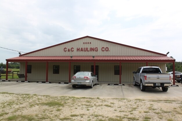
Property Detail
2222 N Highway 95A
35-2N-31-1401-000-000
N1/2 W OF L & N R/R & E OF E LI OF H/W #95A & S OF S R/W LI OF SR #184 OR 7615 P 127 LESS OR 1325 P 462 PENSACOLA ENGINEERING INC LESS MINERAL RIGHTS
Commercialnec
Escambia
HC/LI
Florida
B and X Area of moderate flood hazard, usually the area between the limits of the 100-year and 500-year floods.
13.27 AC
2024
Gonzalez/SW Santa Rosa
2025
Pensacola
003614
Pensacola-Ferry Pass-Brent, FL
6,580 SF
NEARBY LISTINGS FOR SALE OR LEASE
-
-
View all Cantonment listings for sale on LoopNet.com
DEMOGRAPHICS near 2222 N Highway 95A
1 mile
3 mile
5 mile
2025 Total Population
750
7,149
18,097
2030 Population
786
7,432
18,623
Pop Growth 2025-2030
+ 4.80%
+ 3.96%
+ 2.91%
Average Age
39
39
40
2025 Total Households
279
2,643
6,667
HH Growth 2025-2030
+ 4.66%
+ 3.97%
+ 2.94%
Median Household Inc
$77,778
$79,268
$83,970
Avg Household Size
2.70
2.60
2.60
2025 Avg HH Vehicles
2.00
2.00
2.00
Median Home Value
$325,000
$317,088
$313,911
Median Year Built
1994
1988
1990
Nearby Places
Map Layers
Map Styles
 Street
 Aerial
Layers
 Traffic
 Biking
Places
Listings with unknown addresses are not visible on the map
- Restaurants
- Banks
- Shops
- Fitness
- Groceries
PUBLIC TRANSPORTATION
AIRPORT
Pensacola International
Drive
Walk
Distance
Pensacola International
32 min
18.4 mi
Freight Ports
Port of Mobile
Drive
Walk
Distance
Port of Mobile
67 min
55.0 mi
Nearby Properties
Address
Land Use
TOTAL SIZE
Lot Size
Zoning
Address
Land Use
TOTAL SIZE
Lot Size
Zoning
1,631,990 SF
441.31 AC
IND
Address
Land Use
TOTAL SIZE
Lot Size
Zoning
206,625 SF
17.71 AC
HC/LI
Address
Land Use
TOTAL SIZE
Lot Size
Zoning
127,783 SF
23.74 AC
HC/LI
Address
Land Use
TOTAL SIZE
Lot Size
Zoning
73,195 SF
4.90 AC
COM
Address
Land Use
TOTAL SIZE
Lot Size
Zoning
117,000 SF
11.76 AC
HC/LI,IND
Address
Land Use
TOTAL SIZE
Lot Size
Zoning
70,742 SF
21.42 AC
PUB
Address
Land Use
TOTAL SIZE
Lot Size
Zoning
34,268 SF
29 AC
IND
Address
Land Use
TOTAL SIZE
Lot Size
Zoning
29,776 SF
8.25 AC
MDR
Address
Land Use
TOTAL SIZE
Lot Size
Zoning
29,047 SF
5.70 AC
MDR
Address
Land Use
TOTAL SIZE
Lot Size
Zoning
23,474 SF
2.41 AC
HC/LI
Address
Land Use
TOTAL SIZE
Lot Size
Zoning
28,117 SF
8.01 AC
MDR
Address
Land Use
TOTAL SIZE
Lot Size
Zoning
33,648 SF
2.74 AC
HC/LI
Address
Land Use
TOTAL SIZE
Lot Size
Zoning
46,575 SF
4.90 AC
HC/LI
Address
Land Use
TOTAL SIZE
Lot Size
Zoning
17,462 SF
29.77 AC
IND
Address
Land Use
TOTAL SIZE
Lot Size
Zoning
11,650 SF
81.09 AC
AGR
Address
Land Use
TOTAL SIZE
Lot Size
Zoning
17,581 SF
3.36 AC
HC/LI
Address
Land Use
TOTAL SIZE
Lot Size
Zoning
19,635 SF
9 AC
HC/LI
Address
Land Use
TOTAL SIZE
Lot Size
Zoning
533.21 AC
AGR
Address
Land Use
TOTAL SIZE
Lot Size
Zoning
17,400 SF
5.27 AC
IND
Address
Land Use
TOTAL SIZE
Lot Size
Zoning
19,888 SF
8.92 AC
RMU
Address
Land Use
TOTAL SIZE
Lot Size
Zoning
6,500 SF
7.49 AC
HC/LI
Address
Land Use
TOTAL SIZE
Lot Size
Zoning
15,000 SF
2.72 AC
HC/LI
Address
Land Use
TOTAL SIZE
Lot Size
Zoning
8,450 SF
27.60 AC
IND
Address
Land Use
TOTAL SIZE
Lot Size
Zoning
20,432 SF
1.37 AC
LDR
Address
Land Use
TOTAL SIZE
Lot Size
Zoning
9,459 SF
14.75 AC
RMU
Address
Land Use
TOTAL SIZE
Lot Size
Zoning
13,400 SF
17.87 AC
HC/LI
Address
Land Use
TOTAL SIZE
Lot Size
Zoning
8,016 SF
2.34 AC
HC/LI
Address
Land Use
TOTAL SIZE
Lot Size
Zoning
3,035 SF
0.62 AC
HC/LI
Address
Land Use
TOTAL SIZE
Lot Size
Zoning
233.61 AC
RMU
Address
Land Use
TOTAL SIZE
Lot Size
Zoning
6,161 SF
1.73 AC
HC/LI
The World's #1 Commercial Real Estate Marketplace
Connect with us
© 2026 CoStar Group
The information above has been obtained from sources believed reliable. While we do not doubt its accuracy we have not verified it and make no guarantee, warranty or representation about it. It is your responsibility to independently confirm its accuracy and completeness. Any projections, opinions, assumptions, or estimates used are for example only and do not represent the current or future performance of the property. The value of this transaction to you depends on tax and other factors which should be evaluated by your tax, financial, and legal advisors. You and your advisors should conduct a careful, independent investigation of the property to determine to your satisfaction the suitability of the property for your needs.