Property Record
2222 N Wayside Dr, Houston, TX 77020
NEARBY LISTINGS FOR SALE OR LEASE
Property Detail
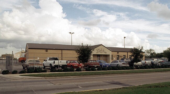
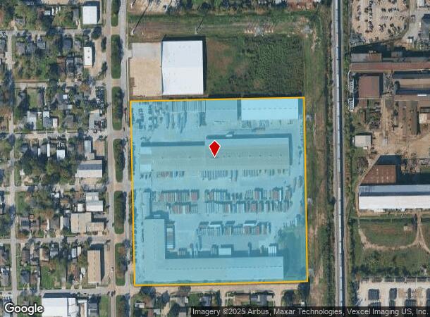
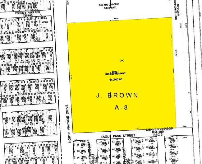
2222 N Wayside Dr
1309850010001
World Trade Distribution
Truckterminal
RES A BLK 1 WORLD TRADE DISTRIBUTION
X
Harris
48201C0695M
Texas
2024
17 AC
2025
Northeast Inner Loop
212400
Houston
189,018 SF
Houston-The Woodlands-Sugar Land, TX
DEMOGRAPHICS near 2222 N Wayside Dr
1 Mile
3 Mile
5 Mile
2024 Total Population
8,412
66,537
259,197
2029 Population
8,560
68,847
267,984
Pop Growth 2024-2029
+ 1.76%
+ 3.47%
+ 3.39%
Average Age
38
38
37
2024 Total Households
2,637
23,321
90,105
HH Growth 2024-2029
+ 1.74%
+ 3.50%
+ 3.66%
Median Household Inc
$39,833
$33,263
$40,341
Avg Household Size
3.10
2.80
2.70
2024 Avg HH Vehicles
2.00
2.00
2.00
Median Home Value
$121,202
$97,768
$144,931
Median Year Built
1953
1958
1961
Nearby Places
Map Layers
Map Styles
 Street
 Aerial
- Restaurants
- Banks
- Shops
- Fitness
- Groceries
PUBLIC TRANSPORTATION
COMMUTER RAIL
Houston (Sunset Limited - Amtrak)
DRIVE
WALK
Distance
Houston (Sunset Limited - Amtrak)
10 min
5.8 mi
AIRPORT
William P Hobby
DRIVE
WALK
Distance
William P Hobby
25 min
12.7 mi
George Bush Intcntl/Houston
DRIVE
WALK
Distance
George Bush Intcntl/Houston
26 min
19.1 mi
Freight Ports
Port of Houston
DRIVE
WALK
Distance
Port of Houston
12 min
6.0 mi
Nearby Properties
Address
Land Use
TOTAL SIZE
Lot Size
Zoning
Address
Land Use
TOTAL SIZE
Lot Size
Zoning
100.26 AC
Address
Land Use
TOTAL SIZE
Lot Size
Zoning
12,206,592 SF
212.18 AC
Address
Land Use
TOTAL SIZE
Lot Size
Zoning
1,392,720 SF
83.75 AC
Address
Land Use
TOTAL SIZE
Lot Size
Zoning
793,077 SF
49.76 AC
Address
Land Use
TOTAL SIZE
Lot Size
Zoning
663,147 SF
40.63 AC
Address
Land Use
TOTAL SIZE
Lot Size
Zoning
Address
Land Use
TOTAL SIZE
Lot Size
Zoning
343,265 SF
41.52 AC
Address
Land Use
TOTAL SIZE
Lot Size
Zoning
438,196 SF
89.88 AC
Address
Land Use
TOTAL SIZE
Lot Size
Zoning
Address
Land Use
TOTAL SIZE
Lot Size
Zoning
240,968 SF
12.45 AC
Address
Land Use
TOTAL SIZE
Lot Size
Zoning
190,512 SF
8.81 AC
Address
Land Use
TOTAL SIZE
Lot Size
Zoning
225,393 SF
20.59 AC
Address
Land Use
TOTAL SIZE
Lot Size
Zoning
433,639 SF
19.89 AC
Address
Land Use
TOTAL SIZE
Lot Size
Zoning
264,866 SF
10.46 AC
Address
Land Use
TOTAL SIZE
Lot Size
Zoning
163,807 SF
8.58 AC
Address
Land Use
TOTAL SIZE
Lot Size
Zoning
175,172 SF
8.81 AC
Address
Land Use
TOTAL SIZE
Lot Size
Zoning
304,925 SF
10.91 AC
Address
Land Use
TOTAL SIZE
Lot Size
Zoning
265,232 SF
13.31 AC
Address
Land Use
TOTAL SIZE
Lot Size
Zoning
250,929 SF
13.17 AC
Address
Land Use
TOTAL SIZE
Lot Size
Zoning
76,842 SF
49.76 AC
Address
Land Use
TOTAL SIZE
Lot Size
Zoning
149,052 SF
7.48 AC
Address
Land Use
TOTAL SIZE
Lot Size
Zoning
210,220 SF
15.38 AC
Address
Land Use
TOTAL SIZE
Lot Size
Zoning
254,904 SF
9.27 AC
Address
Land Use
TOTAL SIZE
Lot Size
Zoning
229,465 SF
9.80 AC
Address
Land Use
TOTAL SIZE
Lot Size
Zoning
Address
Land Use
TOTAL SIZE
Lot Size
Zoning
346,320 SF
12.55 AC
Address
Land Use
TOTAL SIZE
Lot Size
Zoning
223,514 SF
9.23 AC
Address
Land Use
TOTAL SIZE
Lot Size
Zoning
177,720 SF
14.96 AC
Address
Land Use
TOTAL SIZE
Lot Size
Zoning
323,250 SF
14.20 AC
Address
Land Use
TOTAL SIZE
Lot Size
Zoning
199,340 SF
13.27 AC
The World's #1 Commercial Real Estate Marketplace
Connect with us
© 2025 CoStar Group
The information above has been obtained from sources believed reliable. While we do not doubt its accuracy we have not verified it and make no guarantee, warranty or representation about it. It is your responsibility to independently confirm its accuracy and completeness. Any projections, opinions, assumptions, or estimates used are for example only and do not represent the current or future performance of the property. The value of this transaction to you depends on tax and other factors which should be evaluated by your tax, financial, and legal advisors. You and your advisors should conduct a careful, independent investigation of the property to determine to your satisfaction the suitability of the property for your needs.