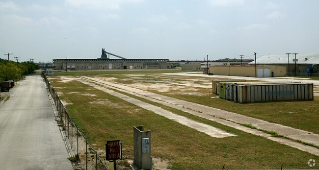
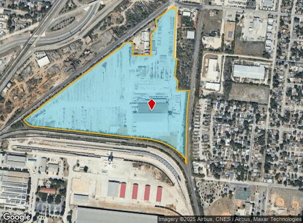
Property Record
2222 W Malone Ave, San Antonio, TX 78225
NEARBY LISTINGS FOR SALE OR LEASE
Property Detail
2222 W Malone Ave
San Antonio-New Braunfels, TX
Tindall Corporation Subd
17319-001-0010
NCB 17319 BLK 1 LOT 1 & NCB A62 P-121 (0.09), P-133 (0.246) & P-133A (.0636) (TINDALL CORPORATION SUBD) PER PLAT 9595/65-71
Lightindustrial
Bexar
X
Texas
48029C0395G
1
2024
47.96 AC
2025
South
160400
San Antonio
231,592 SF
DEMOGRAPHICS near 2222 W Malone Ave
1 Mile
3 Mile
5 Mile
2024 Total Population
9,151
112,153
310,494
2029 Population
9,730
118,730
329,768
Pop Growth 2024-2029
+ 6.33%
+ 5.86%
+ 6.21%
Average Age
38
37
37
2024 Total Households
3,095
37,060
101,877
HH Growth 2024-2029
+ 6.69%
+ 6.08%
+ 6.66%
Median Household Inc
$35,849
$37,116
$38,478
Avg Household Size
2.90
2.90
2.80
2024 Avg HH Vehicles
2.00
2.00
2.00
Median Home Value
$87,487
$88,307
$110,920
Median Year Built
1953
1957
1961
Nearby Places
Map Layers
Map Styles
 Street
 Aerial
- Restaurants
- Banks
- Shops
- Fitness
- Groceries
PUBLIC TRANSPORTATION
COMMUTER RAIL
San Antonio Amtrak Station (Sunset Limited - Amtrak, Texas Eagle - Amtrak)
DRIVE
WALK
Distance
San Antonio Amtrak Station (Sunset Limited - Amtrak, Texas Eagle - Amtrak)
14 min
6.0 mi
AIRPORT
San Antonio International
DRIVE
WALK
Distance
San Antonio International
22 min
12.7 mi
Freight Ports
Calhoun Port
DRIVE
WALK
Distance
Calhoun Port
187 min
150.6 mi
Nearby Properties
Address
Land Use
TOTAL SIZE
Lot Size
Zoning
Address
Land Use
TOTAL SIZE
Lot Size
Zoning
180,980 SF
1,373.90 AC
Address
Land Use
TOTAL SIZE
Lot Size
Zoning
548,048 SF
27.53 AC
Address
Land Use
TOTAL SIZE
Lot Size
Zoning
176,336 SF
18.74 AC
Address
Land Use
TOTAL SIZE
Lot Size
Zoning
442,263 SF
37.97 AC
Address
Land Use
TOTAL SIZE
Lot Size
Zoning
447,169 SF
46.74 AC
Address
Land Use
TOTAL SIZE
Lot Size
Zoning
352,890 SF
19.97 AC
Address
Land Use
TOTAL SIZE
Lot Size
Zoning
245,371 SF
20.50 AC
Address
Land Use
TOTAL SIZE
Lot Size
Zoning
63,850 SF
33.42 AC
Address
Land Use
TOTAL SIZE
Lot Size
Zoning
306,922 SF
32.07 AC
Address
Land Use
TOTAL SIZE
Lot Size
Zoning
218,003 SF
12.33 AC
Address
Land Use
TOTAL SIZE
Lot Size
Zoning
Address
Land Use
TOTAL SIZE
Lot Size
Zoning
251,400 SF
10.62 AC
Address
Land Use
TOTAL SIZE
Lot Size
Zoning
45,363 SF
4.29 AC
Address
Land Use
TOTAL SIZE
Lot Size
Zoning
143,067 SF
11.69 AC
Address
Land Use
TOTAL SIZE
Lot Size
Zoning
56,875 SF
10.04 AC
Address
Land Use
TOTAL SIZE
Lot Size
Zoning
166,270 SF
13.95 AC
Address
Land Use
TOTAL SIZE
Lot Size
Zoning
141,606 SF
13.74 AC
Address
Land Use
TOTAL SIZE
Lot Size
Zoning
360,000 SF
0.01 AC
Address
Land Use
TOTAL SIZE
Lot Size
Zoning
109,591 SF
5.65 AC
Address
Land Use
TOTAL SIZE
Lot Size
Zoning
197,650 SF
20.69 AC
Address
Land Use
TOTAL SIZE
Lot Size
Zoning
47.74 AC
Address
Land Use
TOTAL SIZE
Lot Size
Zoning
48,688 SF
7.77 AC
Address
Land Use
TOTAL SIZE
Lot Size
Zoning
196,328 SF
7.83 AC
Address
Land Use
TOTAL SIZE
Lot Size
Zoning
258,170 SF
17.89 AC
Address
Land Use
TOTAL SIZE
Lot Size
Zoning
34,344 SF
9.79 AC
Address
Land Use
TOTAL SIZE
Lot Size
Zoning
275,840 SF
10.06 AC
Address
Land Use
TOTAL SIZE
Lot Size
Zoning
72,868 SF
14.79 AC
Address
Land Use
TOTAL SIZE
Lot Size
Zoning
51,960 SF
8 AC
Address
Land Use
TOTAL SIZE
Lot Size
Zoning
86,352 SF
5.05 AC
The World's #1 Commercial Real Estate Marketplace
Connect with us
© 2026 CoStar Group
The information above has been obtained from sources believed reliable. While we do not doubt its accuracy we have not verified it and make no guarantee, warranty or representation about it. It is your responsibility to independently confirm its accuracy and completeness. Any projections, opinions, assumptions, or estimates used are for example only and do not represent the current or future performance of the property. The value of this transaction to you depends on tax and other factors which should be evaluated by your tax, financial, and legal advisors. You and your advisors should conduct a careful, independent investigation of the property to determine to your satisfaction the suitability of the property for your needs.