Property Record
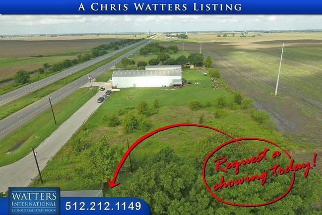
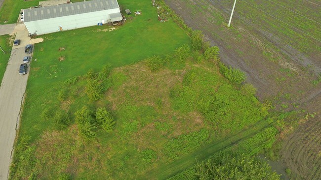
22225 Us Highway 79, Taylor, TX 76574

Property Detail
22225 Us Highway 79
Austin-Round Rock-San Marcos, TX
AW0493 AW0493 - PACE, H. SUR., ACRES 52.867
R006661
WILLIAMSON
Vacantlandnec
Texas
B and X Area of moderate flood hazard, usually the area between the limits of the 100-year and 500-year floods.
1
2024
52.87 AC
2025
Georgetown
020900
Austin
7,200 SF
NEARBY LISTINGS FOR SALE OR LEASE
DEMOGRAPHICS near 22225 Us Highway 79
1 mile
3 mile
5 mile
2025 Total Population
62
1,692
17,153
2030 Population
69
1,908
19,550
Pop Growth 2025-2030
+ 11.29%
+ 12.77%
+ 13.97%
Average Age
43
41
40
2025 Total Households
23
632
6,398
HH Growth 2025-2030
+ 13.04%
+ 13.29%
+ 14.46%
Median Household Inc
$124,999
$83,950
$68,963
Avg Household Size
2.50
2.70
2.60
2025 Avg HH Vehicles
3.00
2.00
2.00
Median Home Value
$466,666
$343,125
$339,341
Median Year Built
1988
1986
1981
Nearby Places
Map Layers
Map Styles
 Street
 Aerial
Layers
 Traffic
 Biking
Places
Listings with unknown addresses are not visible on the map
- Restaurants
- Banks
- Shops
- Fitness
- Groceries
PUBLIC TRANSPORTATION
COMMUTER RAIL
Taylor Amtrak (Texas Eagle - Amtrak)
Drive
Walk
Distance
Taylor Amtrak (Texas Eagle - Amtrak)
6 min
4.1 mi
Freight Ports
Port of Houston
Drive
Walk
Distance
Port of Houston
203 min
166.6 mi
SALE & LEASE HISTORY
LISTING DATE
SALE/LEASE

Jan 26, 2022
For Sale
Aug 24, 2017
For Sale
Nearby Properties
Address
Land Use
TOTAL SIZE
Lot Size
Zoning
Address
Land Use
TOTAL SIZE
Lot Size
Zoning
128,023 SF
13.78 AC
2-M1
Address
Land Use
TOTAL SIZE
Lot Size
Zoning
110,004 SF
27.79 AC
2-M1
Address
Land Use
TOTAL SIZE
Lot Size
Zoning
59,275 SF
3.65 AC
Address
Land Use
TOTAL SIZE
Lot Size
Zoning
Address
Land Use
TOTAL SIZE
Lot Size
Zoning
80,000 SF
3.73 AC
Address
Land Use
TOTAL SIZE
Lot Size
Zoning
Address
Land Use
TOTAL SIZE
Lot Size
Zoning
119,400 SF
14.03 AC
2-M1
Address
Land Use
TOTAL SIZE
Lot Size
Zoning
38,691 SF
5.11 AC
Address
Land Use
TOTAL SIZE
Lot Size
Zoning
33,300 SF
5.71 AC
Address
Land Use
TOTAL SIZE
Lot Size
Zoning
33,200 SF
8.72 AC
Address
Land Use
TOTAL SIZE
Lot Size
Zoning
21.31 AC
Address
Land Use
TOTAL SIZE
Lot Size
Zoning
21.90 AC
Address
Land Use
TOTAL SIZE
Lot Size
Zoning
106,131 SF
6.77 AC
2-M1
Address
Land Use
TOTAL SIZE
Lot Size
Zoning
15,410 SF
5 AC
Address
Land Use
TOTAL SIZE
Lot Size
Zoning
13,120 SF
3.98 AC
Address
Land Use
TOTAL SIZE
Lot Size
Zoning
3,072 SF
6.61 AC
Address
Land Use
TOTAL SIZE
Lot Size
Zoning
3,960 SF
4.65 AC
Address
Land Use
TOTAL SIZE
Lot Size
Zoning
10,560 SF
1.15 AC
Address
Land Use
TOTAL SIZE
Lot Size
Zoning
75,000 SF
2 AC
2-M1
Address
Land Use
TOTAL SIZE
Lot Size
Zoning
8,000 SF
4 AC
3-B1
Address
Land Use
TOTAL SIZE
Lot Size
Zoning
5,000 SF
0.68 AC
Address
Land Use
TOTAL SIZE
Lot Size
Zoning
14,196 SF
3.46 AC
Address
Land Use
TOTAL SIZE
Lot Size
Zoning
1,000 SF
10.09 AC
Address
Land Use
TOTAL SIZE
Lot Size
Zoning
13.82 AC
Address
Land Use
TOTAL SIZE
Lot Size
Zoning
11,243 SF
0.84 AC
Address
Land Use
TOTAL SIZE
Lot Size
Zoning
13,192 SF
4 AC
Address
Land Use
TOTAL SIZE
Lot Size
Zoning
9,226 SF
13.48 AC
Address
Land Use
TOTAL SIZE
Lot Size
Zoning
13,200 SF
0.61 AC
Address
Land Use
TOTAL SIZE
Lot Size
Zoning
440 SF
4.16 AC
The World's #1 Commercial Real Estate Marketplace
Connect with us
© 2026 CoStar Group
The information above has been obtained from sources believed reliable. While we do not doubt its accuracy we have not verified it and make no guarantee, warranty or representation about it. It is your responsibility to independently confirm its accuracy and completeness. Any projections, opinions, assumptions, or estimates used are for example only and do not represent the current or future performance of the property. The value of this transaction to you depends on tax and other factors which should be evaluated by your tax, financial, and legal advisors. You and your advisors should conduct a careful, independent investigation of the property to determine to your satisfaction the suitability of the property for your needs.