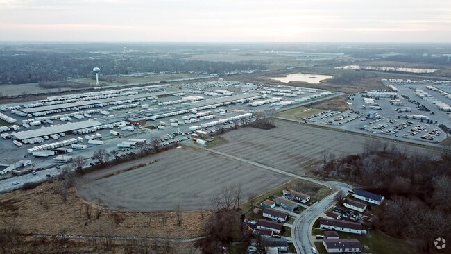
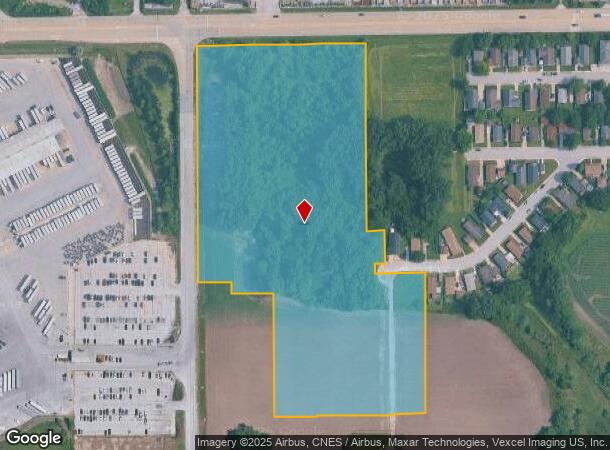
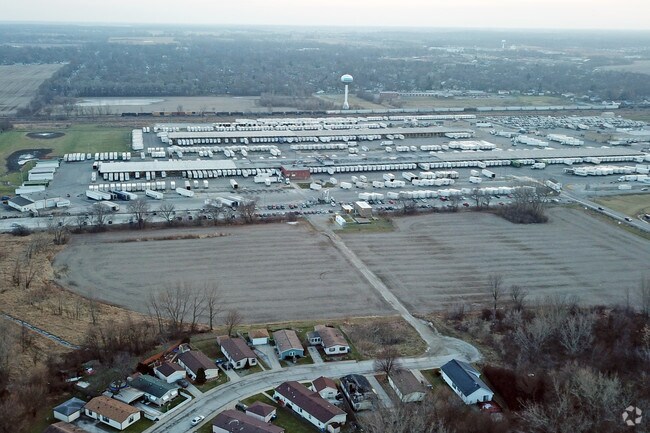
Property Record
2225 Rush St, Lynwood, IL 60411
NEARBY LISTINGS FOR SALE OR LEASE
Property Detail
2225 Rush St
32-24-400-136-0000
Cook
Agriculturalland
Illinois
X
11.99 AC
17031C0764J
Far South
2023
Chicago
2024
Chicago-Naperville-Elgin, IL-IN-WI
828503
DEMOGRAPHICS near 2225 Rush St
1 Mile
3 Mile
5 Mile
2024 Total Population
4,602
36,397
144,850
2029 Population
4,561
35,944
142,969
Pop Growth 2024-2029
(0.89%)
(1.24%)
(1.30%)
Average Age
37
40
41
2024 Total Households
1,554
13,165
53,868
HH Growth 2024-2029
(1.22%)
(1.50%)
(1.50%)
Median Household Inc
$44,344
$61,389
$70,373
Avg Household Size
2.80
2.70
2.60
2024 Avg HH Vehicles
2.00
2.00
2.00
Median Home Value
$73,434
$160,106
$188,521
Median Year Built
1979
1978
1973
Nearby Places
- Restaurants
- Banks
- Shops
- Fitness
- Groceries
PUBLIC TRANSPORTATION
COMMUTER RAIL
Dyer Amtrak (Cardinal - Amtrak)
DRIVE
WALK
Distance
Dyer Amtrak (Cardinal - Amtrak)
10 min
4.6 mi
Flossmoor Station (Metra Electric Line - Northeast Illinois Regional Commuter Railroad (Metra))
DRIVE
WALK
Distance
Flossmoor Station (Metra Electric Line - Northeast Illinois Regional Commuter Railroad (Metra))
17 min
7.9 mi
AIRPORT
Chicago Midway International
DRIVE
WALK
Distance
Chicago Midway International
43 min
28.1 mi
Freight Ports
Port Milwaukee
DRIVE
WALK
Distance
Port Milwaukee
145 min
114.4 mi
SALE & LEASE HISTORY
LISTING DATE
SALE/LEASE

Feb 12, 2019
For Sale
Nearby Properties
Address
Land Use
TOTAL SIZE
Lot Size
Zoning
Address
Land Use
TOTAL SIZE
Lot Size
Zoning
552,813 SF
26.48 AC
Address
Land Use
TOTAL SIZE
Lot Size
Zoning
81,622 SF
9.20 AC
Address
Land Use
TOTAL SIZE
Lot Size
Zoning
138,332 SF
7.08 AC
Address
Land Use
TOTAL SIZE
Lot Size
Zoning
66,240 SF
0.45 AC
Address
Land Use
TOTAL SIZE
Lot Size
Zoning
8.27 AC
Address
Land Use
TOTAL SIZE
Lot Size
Zoning
21,566 SF
25.76 AC
Address
Land Use
TOTAL SIZE
Lot Size
Zoning
16,971 SF
28.05 AC
R33
Address
Land Use
TOTAL SIZE
Lot Size
Zoning
52,195 SF
12.99 AC
Address
Land Use
TOTAL SIZE
Lot Size
Zoning
83,639 SF
5.31 AC
Address
Land Use
TOTAL SIZE
Lot Size
Zoning
42,728 SF
3.22 AC
Address
Land Use
TOTAL SIZE
Lot Size
Zoning
4,763 SF
0.64 AC
Address
Land Use
TOTAL SIZE
Lot Size
Zoning
Address
Land Use
TOTAL SIZE
Lot Size
Zoning
72,404 SF
3.38 AC
Address
Land Use
TOTAL SIZE
Lot Size
Zoning
13,360 SF
2.03 AC
Address
Land Use
TOTAL SIZE
Lot Size
Zoning
304,256 SF
21.50 AC
Address
Land Use
TOTAL SIZE
Lot Size
Zoning
2,845,012 SF
133.73 AC
Address
Land Use
TOTAL SIZE
Lot Size
Zoning
18,610 SF
0.45 AC
R33
Address
Land Use
TOTAL SIZE
Lot Size
Zoning
44,274 SF
3 AC
Address
Land Use
TOTAL SIZE
Lot Size
Zoning
33,834 SF
3.06 AC
Address
Land Use
TOTAL SIZE
Lot Size
Zoning
9,525 SF
3.97 AC
Address
Land Use
TOTAL SIZE
Lot Size
Zoning
64,295 SF
2.23 AC
Address
Land Use
TOTAL SIZE
Lot Size
Zoning
4,752 SF
2.33 AC
R33
Address
Land Use
TOTAL SIZE
Lot Size
Zoning
22,250 SF
6.23 AC
Address
Land Use
TOTAL SIZE
Lot Size
Zoning
26.61 AC
Address
Land Use
TOTAL SIZE
Lot Size
Zoning
42,000 SF
3.34 AC
Address
Land Use
TOTAL SIZE
Lot Size
Zoning
10,091 SF
1.86 AC
Address
Land Use
TOTAL SIZE
Lot Size
Zoning
42,264 SF
5.79 AC
Address
Land Use
TOTAL SIZE
Lot Size
Zoning
11,947 SF
1.50 AC
Address
Land Use
TOTAL SIZE
Lot Size
Zoning
37,016 SF
1.11 AC
Address
Land Use
TOTAL SIZE
Lot Size
Zoning
47,773 SF
6.50 AC
The World's #1 Commercial Real Estate Marketplace
Connect with us
© 2025 CoStar Group
The information above has been obtained from sources believed reliable. While we do not doubt its accuracy we have not verified it and make no guarantee, warranty or representation about it. It is your responsibility to independently confirm its accuracy and completeness. Any projections, opinions, assumptions, or estimates used are for example only and do not represent the current or future performance of the property. The value of this transaction to you depends on tax and other factors which should be evaluated by your tax, financial, and legal advisors. You and your advisors should conduct a careful, independent investigation of the property to determine to your satisfaction the suitability of the property for your needs.