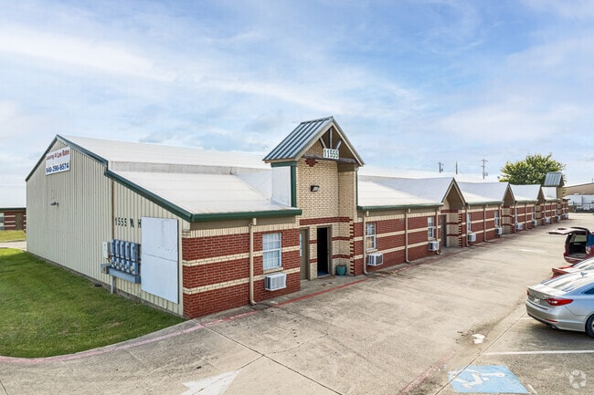
Property Record
2225 W Nail Rd, Krum, TX 76249

Property Detail
2225 W Nail Rd
Dallas-Fort Worth-Arlington, TX
SPRING HILL ESTATES BLK E LOT 1
R194555
DENTON
Commercialacreage
Texas
B and X Area of moderate flood hazard, usually the area between the limits of the 100-year and 500-year floods.
1
2024
2.98 AC
2025
Denton
020405
Dallas/Ft Worth
NEARBY LISTINGS FOR SALE OR LEASE
DEMOGRAPHICS near 2225 W Nail Rd
1 mile
3 mile
5 mile
2024 Total Population
288
7,644
21,348
2029 Population
333
8,592
24,423
Pop Growth 2024-2029
+ 15.63%
+ 12.40%
+ 14.40%
Average Age
40
39
39
2024 Total Households
94
2,579
7,588
HH Growth 2024-2029
+ 15.96%
+ 12.56%
+ 14.77%
Median Household Inc
$121,428
$113,723
$97,369
Avg Household Size
3.00
3.00
2.80
2024 Avg HH Vehicles
3.00
2.00
2.00
Median Home Value
$572,581
$383,202
$393,749
Median Year Built
2002
2003
2004
Nearby Places
Map Layers
Map Styles
 Street
 Aerial
Transit
 Traffic
 Biking
Places
Listings with unknown addresses are not visible on the map
- Restaurants
- Banks
- Shops
- Fitness
- Groceries
PUBLIC TRANSPORTATION
COMMUTER RAIL
Downtown Denton Transit Center (A-train - Denton County Transportation Authority)
Drive
Walk
Distance
Downtown Denton Transit Center (A-train - Denton County Transportation Authority)
12 min
8.1 mi
AIRPORT
Dallas-Fort Worth International
Drive
Walk
Distance
Dallas-Fort Worth International
40 min
33.3 mi
Freight Ports
Port of Shreveport
Drive
Walk
Distance
Port of Shreveport
259 min
239.8 mi
SALE & LEASE HISTORY
LISTING DATE
SALE/LEASE

Sep 29, 2020
For Lease
Mar 23, 2018
For Lease
Nearby Properties
Address
Land Use
TOTAL SIZE
Lot Size
Zoning
Address
Land Use
TOTAL SIZE
Lot Size
Zoning
238,200 SF
85.31 AC
Address
Land Use
TOTAL SIZE
Lot Size
Zoning
167,850 SF
48.14 AC
Address
Land Use
TOTAL SIZE
Lot Size
Zoning
141,468 SF
24.72 AC
Address
Land Use
TOTAL SIZE
Lot Size
Zoning
164,211 SF
11.95 AC
Address
Land Use
TOTAL SIZE
Lot Size
Zoning
126,126 SF
9.45 AC
Address
Land Use
TOTAL SIZE
Lot Size
Zoning
86,702 SF
15.16 AC
Address
Land Use
TOTAL SIZE
Lot Size
Zoning
200,794 SF
37.89 AC
Address
Land Use
TOTAL SIZE
Lot Size
Zoning
337,607 SF
27.76 AC
Address
Land Use
TOTAL SIZE
Lot Size
Zoning
53,384 SF
19.62 AC
Address
Land Use
TOTAL SIZE
Lot Size
Zoning
14,220 SF
14.47 AC
Address
Land Use
TOTAL SIZE
Lot Size
Zoning
13,152 SF
15 AC
Address
Land Use
TOTAL SIZE
Lot Size
Zoning
110.88 AC
Address
Land Use
TOTAL SIZE
Lot Size
Zoning
76,600 SF
4.96 AC
Address
Land Use
TOTAL SIZE
Lot Size
Zoning
18,690 SF
9.33 AC
Address
Land Use
TOTAL SIZE
Lot Size
Zoning
21,000 SF
20.42 AC
Address
Land Use
TOTAL SIZE
Lot Size
Zoning
51,840 SF
5.93 AC
Address
Land Use
TOTAL SIZE
Lot Size
Zoning
99,000 SF
5.90 AC
Address
Land Use
TOTAL SIZE
Lot Size
Zoning
43,680 SF
4.24 AC
Address
Land Use
TOTAL SIZE
Lot Size
Zoning
40,320 SF
4.39 AC
Address
Land Use
TOTAL SIZE
Lot Size
Zoning
9,750 SF
5.45 AC
Address
Land Use
TOTAL SIZE
Lot Size
Zoning
75,729 SF
4.40 AC
Address
Land Use
TOTAL SIZE
Lot Size
Zoning
75,480 SF
6.07 AC
Address
Land Use
TOTAL SIZE
Lot Size
Zoning
73,500 SF
4.05 AC
Address
Land Use
TOTAL SIZE
Lot Size
Zoning
14.53 AC
Address
Land Use
TOTAL SIZE
Lot Size
Zoning
32,800 SF
5.93 AC
Address
Land Use
TOTAL SIZE
Lot Size
Zoning
15,867 SF
4.77 AC
Address
Land Use
TOTAL SIZE
Lot Size
Zoning
1,360 SF
12.82 AC
Address
Land Use
TOTAL SIZE
Lot Size
Zoning
6.95 AC
Address
Land Use
TOTAL SIZE
Lot Size
Zoning
141.65 AC
Address
Land Use
TOTAL SIZE
Lot Size
Zoning
13,120 SF
3.64 AC
The World's #1 Commercial Real Estate Marketplace
Connect with us
© 2026 CoStar Group
The information above has been obtained from sources believed reliable. While we do not doubt its accuracy we have not verified it and make no guarantee, warranty or representation about it. It is your responsibility to independently confirm its accuracy and completeness. Any projections, opinions, assumptions, or estimates used are for example only and do not represent the current or future performance of the property. The value of this transaction to you depends on tax and other factors which should be evaluated by your tax, financial, and legal advisors. You and your advisors should conduct a careful, independent investigation of the property to determine to your satisfaction the suitability of the property for your needs.